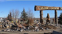
Chetwynd is a small town of 2,500 (2016) in the Peace Country and Northern Rockies region of British Columbia. It acts as the gateway to the Peace River Country. Chetwynd has dozens of chainsaw carvings displayed throughout town as public art. It is home to a Northern Lights College campus. Nearby, there are four provincial parks, two lakes, and several recreational trails.
Understand
edit
Chetwynd is a district municipality in the foothills of the Rocky Mountains in northeastern British Columbia. Situated on an ancient floodplain, it is the first town eastbound travellers encounter after emerging from the Rockies along Highway 97. The town developed during the construction of infrastructure through the Rocky Mountains in the 1950s, and was used as a transshipment point during the construction of hydroelectric dams in the 1960s and 1970s and the new town of Tumbler Ridge in the early 1980s. The town's population has increased little if at all since the 1980s but is significantly younger than the provincial average.
Once known as Little Prairie, the community adopted its current name in honour of provincial politician Ralph L.T. Chetwynd, just prior to its incorporation in 1962. The 64-km² (25 sq mi) municipality consists of the town, a community forest, and four exclave properties.
- Chetwynd Visitor Centre, 5400 North Access Road (north side of Hwy 97 along the frontage road), ☏ +1 250-788-1943, tourist@gochetwynd.com.
Get in
editBy car
editHighways 29 and 97 intersect in Chetwynd; the John Hart Highway portion of Highway 97 runs east-west through town, connecting Dawson Creek 102 km (63 mi) east and Prince George 304 km (189 mi) south. Highway 29 (Don Philips Way) runs north-south through Chetwynd, connecting to Hudson's Hope 60 km (37 mi) north and Tumbler Ridge 89 km (55 mi) southeast.
By bus
edit- BC Bus North, ☏ +1-844-564-7494. Twice per week bus service between Prince George and Fort St. John with stops in Mackenzie, Chetwynd, Dawson Creek, and Taylor. Fare is $48.
Get around
editSee
edit- Chainsaw Carvings. A public art program, started in 1987, showcases over 120 chainsaw carvings spread throughout town with a downtown monument that declares Chetwynd the "Chainsaw Sculpture Capital of the World". The town's first annual chainsaw carving contest was held in June 2005.
- 1 Little Prairie Heritage Museum, 5633 Westgate Road, ☏ +1 250-788-1943. Located in one of the town's oldest buildings (a converted post office dating to 1949) displays artifacts and re-creations of the town's frontier times, and nostalgia pieces from the construction of infrastructure through the Rocky Mountains.
Nearby
edit- 2 W.A.C. Bennett Dam Visitor Centre (from the intersection with Highway 97 in Chetwynd, drive north on Highway 29 for 65 km, then turn at left in the town of Hudson's Hope at Canyon Dr, then follow Canyon Dr for 19 km, where you will see the dam), ☏ +1 250-783-5048, bennett@bchydro.com. operates mid-May to early September: 10AM-5PM. Go on a tour of this dam including the turbine room. The W.A.C. Bennett Dam is one of the world's largest earth-fill structures. Adult $8, child or senior $7.
Do
editChetwynd has a large indoor rodeo facility, an outdoor speed skating oval, and a general recreation complex with an ice arena, wave pool, six-lane curling rink, two baseball diamonds, and a skateboard park. It has a rock climbing wall, indoor walking track and fitness centre. For outdoor recreation, a community forest on Mount Baldy provides residents with trails for walking, hiking, cycling, and cross-country skiing.
- 1 Powder King Mountain Resort, Mile 122 John Hart Hwy (Hwy 97) (110 km W of Chetwynd on Hwy 97), toll-free: +1-866-POW-KING (769-5464), powderhound@powderking.com. Located in the Pine Pass area of the Northern Rockies of British Columbia’s Northeastern Interior. It is the only year-round destination alpine resort in North America found alongside a major route (Highway 97). Ranked #3 in all of North America, the area boasts the best snow quality of all Canadian ski hills.
- Gwillim Lake Provincial Park. Located about 30 minutes drive away, roughly half way between Chetwynd and Tumbler Ridge, see listing under Tumbler Ridge.
Learn
edit- 1 North Lights College (NLC) - Chetwynd campus, 5132 50 Street, ☏ +1 250-788-2248, toll-free: +1-866-463-6652. Publicly funded college.
Buy
edit- 1 51st St NW. Shopping in Chetwynd is somewhat concentrated along this street and streets running off it.
Groceries
edit- 2 Gerry's Freshmart, 5008 50th Ave NW, ☏ +1 250-788-8899.
- 3 IGA, 5001 50 Ave, ☏ +1 250-788-2422.
Goods
edit- 4 Field's, 5044 49th Ave, ☏ +1 250-788-3056. House and home, footwear, and fashion,
Eat
edit- 1 Dragon Palace, 5317 South Access Road, ☏ +1 250-788-3700. Daily 10AM-10PM.
- 2 The Riverhouse, 5224 53rd Street (at Pine Cone Motor Inn), ☏ +1 250-788-1038. Daily 6:30AM-2PM, 5-10:30PM.
- 3 New Tokyo Sushi Japanese Restaurant, 4800 N Access Rd, ☏ +1 250-788-8890.
Drink
edit- 1 Links Pub & Grill, 4613 47th Avenue NE, ☏ +1 250-788-9594, info@linkspubandgrill.ca. Su-Th 11AM-midnight, F Sa 11AM-1AM.
Sleep
edit- 1 Days Inn, 4401 53rd Ave, ☏ +1-250-788-3344, toll-free: +1-800-329-7466. Check-in: 3PM, check-out: 11AM.
- 2 Lakeview Inns & Suites, 4820 North Access Road, ☏ +1 250-788-3000, toll-free: +1-877-355-3500, chetwynd@lakeviewhotels.com. Check-in: 3PM, check-out: 11AM.
- 3 Peace River Inn & Suites, 5100 50th St, ☏ +1 250-556-6000, info@prinn.ca.
- 4 Pine Cone Motor Inn, 5224 53rd St, ☏ +1 250-788-3311.
- 5 Pomeroy Inn & Suites, 5200 North Access Road, ☏ +1 250-788-4800, toll-free: +1-866-424-4800, gm@pomeroychetwynd.com.
- 6 Stagecoach Inn, 5413 South Access Road, ☏ +1 250-788-9666, toll-free: +1-800-663-2744, stagecoachinn@hotmail.com.
Connect
editCope
edit- 2 Chetwynd Hospital and Health Centre, 5500 Hospital Rd, ☏ +1 250-788-2236. Has an emergency department.
Go next
editContinue to the Alaska Highway in Dawson Creek.
| Routes through Chetwynd |
| Fort St. John ← Hudson's Hope ← | N |
→ Tumbler Ridge → END |
| Kamloops / Hope ← Prince George ← | W |
→ Dawson Creek → Whitehorse |

