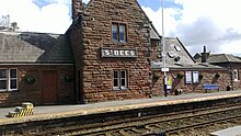
The Coast To Coast Walk (properly "A Coast To Coast Walk") is a 190-mile long-distance walking trail in England which crosses the North of England from St Bees in Cumbria on the West coast to Robin Hood's Bay in North Yorkshire on the East coast.
Understand
editThe walk (known as the 'C2C') was created in 1972 by Alfred Wainwright, when, in response to the creation of the Pennine Way, he set about devising the best walk he could imagine in England. It has never been adopted as an official National Trail, though a campaign has begun, but is hugely popular, and once came second (after the Milford Track) in a poll among travel writers conducted by Country Walking magazine to find the finest walk in the world.
Along its route the walk passes through three National Parks: The Lake District, the Yorkshire Dales, and the North York Moors. The creator suggested walking from West to East in order to enjoy the best possible views, and to have any prevailing weather at your back rather than in your face.
The original guidebook was written in Wainwright's characteristic style of hand-written text and hand-drawn maps, in the same manner as his seminal Pictorial Guides to the Lakeland Fells.
Prepare
edit
The walk typically takes people two weeks to complete, longer if you adopt Wainwright's 'stop and stare' approach. You'll want a copy of the guidebook, maps, and suitable outdoor gear. The walk crosses through the mountains of the Lake District but generally keeps to the passes, apart from the occasional option to cross summits.
Walkers may split the walk in various ways to suit the distance they want to walk in a day, though the availability of accommodation may limit this. The author suggested breaking the walk into twelve days, which makes about 16 miles a day. Some find this a little too much for comfort and choose to have the odd rest day or a couple of short days, or even to take other transport as substitution for a day or two.
Get in
edit
To St Bees.
By train
St Bees has a station on the Cumbrian Coast rail line. From the West Coast Main Line, change at Carlisle or Lancaster off the west Coast main line, or at Barrow-in-Furness. There are, as of 2013, 21 stopping passenger trains a day. The station is on the Main Street in the centre of the village, where there are three pubs within 5 minutes' walking. It is a 20-minute walk to the official start of the Coast to Coast walk at the main beach.
By car
Leave the M6 at junction 40 (Penrith) and head west along the A66 to Cockermouth, then south along the A5086 to Egremont. St Bees is a couple of miles to the west and will be signposted.
Walk
edit
The walk starts at the seawall at the main beach in St Bees; there is a monument to mark this with an interpretation board. The scenery throughout is beautiful, but also varied, since you pass through a number of different types of landscapes. The start is a coastal walk, with cliffs, seabirds, and a lighthouse. Soon after heading inland you pass through the Lake District, designated a UNESCO World Heritage Site in 2017, which has a fantastic variety of landscapes. The northern part of the Yorkshire Dales is limestone country, then the Vale of Mowbray is lower-level terrain. The North York Moors are peaty moorlands, and finally you reach the sea once more at Robin Hood's Bay among the highest cliffs in England.
Eat
editFor some of days of the walk, there will be no pubs or cafés during the majority of the length of the day's walk; avail yourself of a packed lunch if staying in accommodation if the option is available.
Drink
editThe Falling Foss tea garden has tea and a playground for children. There are many cafés and public houses along the route, others very close by, that provide non-alcoholic refreshments, hot drinks and the usual range of beers.
Sleep
editYour main options are Bed & Breakfast (with occasional youth hostel options) or camping (including a Mongolian yurt at one point). Many accommodation guides for the walk have been produced over the years. Doreen Whitehead's guide to accommodation on the 'C2C' is legendary with walkers.
Cope
editAn option to lighten the load is a daily baggage transfer service, such as pack horse or Sherpa Van[dead link], who will take your luggage to the next day's finish point for around £10 per bag.
Stay safe
editYour main risks are keeping on track and route finding in low cloud, especially in the Lake District. The walk passes close to Seathwaite which has the highest recorded annual rainfall in England so if (when) it rains, having the right waterproofs and walking gear is important.
Go next
editThere are several other long distance walks in the United Kingdom.
- The Pennine Way is a 268-mile walk in northern England.
- Southern Upland Way is a 212-mile coast to coast walk in southern Scotland.
- The Great Glen Way is a 73-mile walking and cycling route from coast to coast in northern Scotland.
