Diving Mayor Island


This article is intended to provide the already qualified Scuba diver with information which will help to plan dives in the waters of Mayor Island, off the east coast of the Coromandel Peninsula, Bay of Plenty, North Island of New Zealand, whether as a local resident or a visitor. Information is provided without prejudice, and is not guaranteed accurate or complete. Use it at your own risk.
Understand
editThe island is called Tuhua in the Māori language, after the black obsidian (volcanic glass) of the same name found on the island, which they prized as a material for cutting tools.
Captain James Cook named it Mayor Island when he sighted it on November 3, 1769, in recognition of the Lord Mayor's Day to be held in London a few days later.
Mayor Island is a wildlife refuge. There are a few holiday houses in Opo Bay (South East Bay) on the south coast, where there is a secure anchorage unless the wind is from the south east.
General topography
editMayor Island is a dormant shield volcano off the Bay of Plenty coast of New Zealand's North Island. It is 35 km (22 mi) north of Tauranga and has an area of 13 km² (5 sq mi). The island has a mostly precipitous coastline, and maximum height of 355 m (1,165 ft) above sea level.
The island is thought to have risen from the sea about 7000 years ago, and the most recent lava flows have been dated at between 500 and 1,000 years old.
Climate, weather and sea conditions
editWeather reports for coastal weather region Plenty are broadcast on VHF. The nearest weather stations are Slipper Island and White Island.
Water temperature may be as low as 14°C
Marine ecology
editThe waters within 800 m of the north shoreline are a marine reserve.
Equipment
editRegular recreational diving equipment is adequate for most dives in this region.
Dive sites
editCrater Bay
edit

- Understand: — An open bay under a high cliff, with sand bottom and good anchorage. Bands of black obsidian can be seen glittering in the strata of the cliff face, and shards are scattered on the bottom.
- Position: — S37.28588° E176.27328° About halfway along the east side of the island. The crater is just over the cliffs.
- Depth: — Fairly shallow.
- Topography: — Shoreline reef starts about 3.5m deep. Medium to low profile rocky reef mostly of boulders with occasional outcrops.
- Marine life and features: — Mostly quite heavy growth of wide range of turf seaweeds. Not much fish life and not much mobile invertebrate diversity.
- Conditions: — Good anchorage on sand bottom at about 8m depth.
Archway Island
edit- Understand: — The next bay north of Crater Bay, characterised by a small inshore islet with a natural arch through it, and an underwater ridge running seaward from the islet. Reasonable anchorage on rocky reef, but fairly deep, at about 20m. Some risk of anchor fouling due to bottom structure.
- Position: — S37.27681° E176.27820°
- Depth: — depth increases rapidly to over 20m within a short distance from the shore.
- Topography: — Short arch tunnel through small volcanic rock islet right up near shoreline cliffs. Archway about 7m deep. similar width and height above water. Gulley inshore about 9m with narrow sand bottom. Gully offshore considerably deeper.
- Marine life and features:— Fairly barren rock surface in archway. Also fairly barren in gulley but some kelp and small amounts of other seaweeds. Much more lush reef cover further out on the seaward face.
- Conditions: — Very well protected from westerly winds and swell, and moderately protected from northerly and southerly winds and swell, but very exposed to anything from the east.
Tuhua Reef
edit- Understand: — Large offshore reef to the south east of Mayor Island. It is not in a marine reserve, and there are usually a large number of lobster pots with their associated floats over the shallower areas. This is a mixed blessing, as they help to identify the reef, help to keep station, but are a serious risk of fouling the propellers.
- Position: — S37.30528° E176.28799°
- Depth: — 6 to 60m
- Topography: — Large reef with depths from 6m down to over 60m on the outside edges. Large shallow area above 10m, with deep and shallow gullies
- Marine life and features: — Very heavy and healthy kelp cover. Large numbers of fish on a good day. Moderate variety of invertebrates present but you have to go looking for them in the gullies.
- Conditions: — This is an open water reef, exposed to the wind from all directions, but moderately protected from swell from the west and north west.
Ruakikeno Point
edit- Understand: — A small point and south east facing bay just to the east of South East Bay anchorage.
- Position: — S37.30475° E176.26796°
- Depth: — at least 12m deep.
- Topography: — Rocky reef, probably volcanic sediments. Moderate profile ridges and gullies. Rock fairly porous and weathered with odd holes and crevices
- Marine life and features: — Heavy kelp cover except on walls and in shallows.
- Conditions: — Exposed to wind and waves from the south and east, protected from north easterly to south westerly wind and swell.
Two Fathom Reef
edit- Understand: — Offshore reef, but not very far offshore, so it is partly protected by the island from wind, and waves.
- Position: — S37.25845° E176.26906°
- Depth: — 3 to 40m.
- Topography: — Large flattish topped rocky reef with some deep gullies and steep sections. Some parts moderately sloped with fairly high profile.
- Marine life and features: — Marine reserve. Heavy kelp forest in healthy condition. Moderate fish diversity. Large shoals of koheru, blue mao mao, trevally and kingfish may be seen above the top of reef, demoiselles a little deeper.
- Conditions: — Very well sheltered from wind and swell from the south west to south east, but quite exposed to the north. Anchorage on rocky reef with some risk of fouling. Check the anchor at the start of a dive.

North Rock
edit- Understand: — A small islet just off the north shore of Mayor Island.
- Position: — S37.26558° E176.27007°
- Depth: — up to about 18m.
- Topography: — Fairly steep sides to the islet, with relatively flat reef between the rock and the main island.
- Marine life and features: — Marine reserve. Heavy kelp in good condition. Moderate variety of fish but not much in mobile invertebrates.
- Conditions: — Anchorage in the channel is fairly secure in depths of around 18m, but on quite rugged reef, so there is a risk of fouling the anchor. Check during the dive. Sheltered from wind and swell from the south but exposed to the north.
- Hazards: — Fairly strong currents may flow between the islet and the main island, which can make it difficult to swim back to a moored boat. These currents can develop quite quickly and may be tidal.
- Equipment: — A drift line is worth considering when diving from a boat anchored in the channel.
Motuneka Rock
edit- Understand: —
- Position: — S37.26878° E176.24698°
- Depth: — 8 to 25m
- Topography: — High profile boulders and bedrock at base of cliff with lots of gaps, holes, overhangs, gullies and pinnacles.
- Marine life and features: — Marine reserve. Kelp below about 6m and dense growths of other seaweeds above. Not much in mobile invertebrates but fair number of Kina.
- Conditions: — Surge can be very strong in the inshore gullies and over the tops of large boulders. Exposed to wind and swell from the north, but well protected from weather from the south.
Opoupoto Bay
edit- Understand: — A small bay under the cliffs at the western end of the marine reserve.
- Position: — S37.27266° E176.24120°
- Depth: — 10 to 25m
- Topography: — The reef to the south east of the bay starts at about 9m, with sand bottom sloping gradually down to the north to at least 12m. Sand bottom from 12m to 9.5m then boulder field of large and small boulders and some bedrock. Low ridges perpendicular to shoreline.
- Marine life and features: — Marine reserve. Moderate density kelp on top of most rocks but also other weeds and some areas relatively barren. Fair numbers of fish may be present over the reef.
- Conditions: — Exposed to wind and waves from the north, but very well protected from anything from the south.
- Hazards: — Surge may be very strong in the shallows
Respect
edit- No fishing, collecting or disturbing of marine life is permitted in the reserve. This includes feeding of fish.
- It is an offense to litter or discharge untreated sewage in the reserve.
- Anchoring should be done with due consideration for potential damage to the benthic ecology.
- Divers should ensure that their equipment is secured so that items do not dangle and impact on the reefs.
- Divers should control their buoyancy and maneuver with care to avoid kicking and otherwise coming into unnecessary contact with the reefs, particularly in confined spaces.
Get help
editEmergency services
- . Police.
- . Ambulance service
- . Sea rescue
- . Recompression chamber
- . DAN hotline
Get service
editThere are no diving services available on the island.
Do
editGet around
editAccess to the island and dive sites is by boat. On the island you can walk. There are no vehicles.
Stay safe
edit- Hazards: — stromg surge at shallow inshore sites, and tidal currents may make it difficult to return to the boat
- Skills: — No special skills recommended
- Equipment: — No special equipment recommended
See
edit- Marine life and features: —
 Mixed shoal of trevally and blue mao mao in the MPA
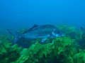 Large blue moki over kelp forest in the MPA
 Bluefish in the MPA
 Marblefish in the MPA
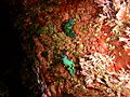 Elysia sacoglossans in the MPA
 Gem nudibranch in the MPA


