The dive site Cleeve's Tunnel is an inshore rocky reef in the Clifton area on the Cape Peninsula, near Cape Town in the Western Cape province of South Africa.
Understand
edit
The site is notable for the relatively long and fairly tight swim-through tunnel under a large pinnacle.
Position
editName
editCleeve's Tunnel is named for the diver who either discovered the tunnel or at least made its position known.
Depth
editMaximum depth is about 20 m. and the top of the pinnacle is about 3 m. Average depth is likely to be about 12 m, and the tunnel bottom is from 15 m at the north entry to 17 m at the south entry, and maybe a metre or so shallower in the middle.
Visibility
editVisibility may exceed 20 m after an upwelling, but will usually be less.
Topography
edit
Cleeve's Tunnel is a low and relatively narrow space under a huge boulder pinnacle that stands on an even larger bedrock base at a depth of between 15 and 18 m. The local bottom is at about 20 m, and the peak of the pinnacle at slightly less than 3 m depth. The reef breaks in moderate to rough weather, and probably at low tide in anything less than very low swell.
The pinnacle comprises several large rocks and there are undercuts where it stands on the base rock, some of which are quite large overhangs, and as mentioned, in the middle of the formation, the main tunnel extends through from north to south, and is large enough to allow somewhat constricted passage to an average sized diver with backmount cylinder.
A map showing the approximate layout of this pinnacle and the position of the entrances to the tunnel is shown. The tunnel is fairly wide to the north, but has low headroom: a diver with a 15 litre cylinder is likely to touch the top or bottom several times during a transit. The tunnel's southern entrance is at about 17 m depth, and the northern entrance at about 15 m. The length is about 35 m, and the axis of the tunnel is about 040°magnetic. If visibility is good, light can be seen through the tunnel from the south entry from two places, to the east of the opening and to the west.
The pinnacle is very shallow on top, where it rises to within 3 m of the surface. It is fairly large, and is about 45 m north to south, and 90 m east to west at a depth of 15 m. On the south side there is a tall narrow rock a couple of metres away from the main reef, and the southern entry to the tunnel is under the overhang to the west of this rock. This overhang is about 6 to 8 m wide, and there is a visible tunnel through on both east and west sides. The west side is known to be sufficient space for an average sized male diver with a 203mm diameter cylinder (steel 15 litre or 12 litre dumpy or aluminium 12 litre) on a backplate and wing harness. The east side is not known to have clearance, and looks tighter from outside. The diver who reported the tunnel also described a dog-leg, which was not found during the survey. this may indicate another route through.
At the east side of the pinnacle, another tunnel has been found, also at a depth of about 17 m. It is roughly parallel to the main tunnel, but is formed by the triangular space between two large boulders lying on the base rock. This tunnel has not yet been transited, and the clearance is unknown. The north entry is unknown, and the position on the map is a guess. The south entry is not obvious, as it is down a crevice a couple of metres, but once there, light can be seen at the far end. The tunnel looks large enough for a diver, and appears higher than the width, and almost straight.
Geology: Pre-Cambrian granite of the Peninsula pluton
Conditions
editThe site is exposed to westerly winds and seas so should be dived when the westerly components of the swell are low and short period, particularly if you are considering a transit of the tunnel as this could be excessively exciting in a strong surge.The site should be good in flat seas during or soon after south easterly winds. The site is well protected from south easterly winds, but if they become too strong the water may become unpleasantly choppy and the ride home will be wet and bumpy.
The site is usually at it's best in summer but there are also occasional opportunities in autumn.
This is an area which sometimes has upwellings of cold clear water following strong south easterly winds. these will usually be followed by a plankton bloom which will reduce the visibility without raising the temperature.
Get in
editThis site is normally a boat dive from Oceana Power Boat Club slipway. The distance is about 8.2 km
See
editMarine life
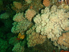
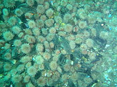
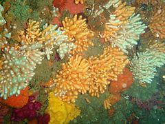
editHeavy red bait growth on top, with some kelp. Sides covered with assorted sponges, black mussels, nippled sea fans, multicoloured sea fans, noble corals, sea urchins, west coast rock lobster, solitary and colonial fanworms, arborescent bryozoans and hydroids, starfish, anemones, soft corals and colonial ascidians. Shoals of Hottentot seabream may be seen.
- Marine life typical of the shallower parts of the reef at Cleeve's Tunnel
- The outlier to the east has heavy growth of Cauliflower soft corals
- Much of the low angle rock face is colonised by sea urchins
- Some parts of the south eastern wall of the pinnacle are densely covered by nippled sea fans
- Lace false coral
Features
editThe main feature of this site is the tunnel which gives it its name.
Photography
editThere are many subjects for macro photography, and if the visibility is good, wide angle could produce interesting results inside the tunnel.
Suggested Routes
editThe obvious route is the tunnel, but that is a do it at your own risk route, and the ends are easy to find, so go there, assess the conditions and make your own decision about how to go about it.
The rest of the reef is pleasantly colourful and does not have any particular routes at this point. A possibility is to start at the south entry to the tunnel, look into and through it, taking into account the surge conditions and visibility on the day, then work your way around the base and sides of the pinnacle until you get to the north entry, where you can take another look under the overhangs before making your way up to the top of the pinnacle for a safety stop with a view. Just be careful if the surge is strong. Surface downwind/downcurrent from the peak for a safer pickup.
Stay safe
editHazards
editThere are two significant site hazards. Firstly the pinnacle extends to within 3 m of the surface, and will break if there is much of a swell running. Generally if there is a break, the tunnel will be particularly unsafe due to surge currents which could wedge a diver between the floor and ceiling of the tunnel, and there are many places where this is possible. The break is also a hazard to the dive boat, and if the swell is in sets, it may look safe until suddenly a large set comes though and breaks. This would not be a good time for a boat to be over the pinnacle peak.
The other hazard is the tunnel. It is low headroom and slopes gradually from the highest parts towards the sides, so the majority of the section has places too low for a diver to fit through, and most of these are gradual reductions in clearance, so it is quite possible to be swept along by surge and wedged in tightly between the roof and floor. This is not a place for inexperienced divers. The tunnel is about 35 m long, and the tightest constrictions are about in the middle, quite a difficult place to assist a person who is trapped. The south entry is more constricted than the north side overhang, so it may be advisable to make first transit attempts from the south, as once past the midway point the rest of the way north is relatively clear.
Skills
editDivers should not attempt the tunnel transit unless they are suitably skilled. If you get it wrong, you were not suitably skilled.
Equipment
editLarge divers should consider low profile rigs if they wish to do the tunnel transit. Sidemounts would probably allow all but the largest to get through, but any transit is entirely at the diver's own risk.
Nearby
editBack to the Alphabetical list of sites, or list of dive sites in the Clifton area
Other regional dive sites:
- Dive sites of the Cape Peninsula west coast
- Dive sites of the Cape Peninsula east coast
- Dive sites of False Bay offshore and approaches
- Dive sites of False Bay east coast
- Fresh water dive sites of the Cape Town Metropolitan Area


