Diving the Cape Peninsula and False Bay/Finlay's Point

The dive site Finlay's Point or Jenga Reef is an inshore rocky reef in the Castle Rocks restricted zone on the False Bay coast of the Cape Peninsula, near Cape Town in the Western Cape province of South Africa.
Understand
edit

The site is sometimes used as an alternative when conditions are found to be unsuitable on the planned site further south on the peninsula, as visibility here has been considerably better on those occasions. There is more extensive reef in this area than previously anticipated. This has been shown on the SA Council for Geoscience's sidescan sonar surveys of the area done in 2010/1011. This area is inside the Castle Rocks restricted zone of the Table Mountain Marine Protected Area, it is likely that there will be fairly abundant fish life on the reefs.
Position
edit- S34°14.926' E018°28.653' 1 Finlay's Point The last group of big boulders on the coastline to the north of and before Partridge Point.
- S34°14.865' E018°28.600' 2 Finlay's Point Swimthroughs A group of three large exposed rocks 140m north of the point
This site is in a Marine Protected Area (2004). A permit is required. The site is entirely inside the Castle Rocks Restricted Zone.
Name
edit"Finlay's Point" is the name for this area shown on maps and charts of the Cape Peninsula. The origin of the name Jenga reef is unknown. The name itself probably derives from the game of balancing blocks, but it is not clear how this applies to the reef, unless it was given to a section of jumbled boulders.
Depth
editMaximum depth of 15 m is quite far out, however 10 m is fairly close inshore.
Visibility
editVisibility is usually very similar to the rest of the surrounding area, but there have been occasions where there has been significantly better visibility at Findlays Point than at partridge Point, with a visible border between the good and bad regions. This probably results from wind influence on local water movement, as Findlay's Point is a bit more protected from wind than Smitswinkel Bay, and Partridge Point is at the north border of Smitswinkel Bay.
Topography
editFinlay's Point — There is a shallow sandy patch to south of the big boulders. The bottom is mostly low to moderate profile rocky bedrock reef and boulders of assorted sizes, some pretty big, in chaotic arrangement. Directly off the big rocks of the point is an area of big boulders and relatively rugged reef, with small patches of sand.
Finlay's Point swimthroughs — To the north of the point is a group of 3 big boulders which extend above the water near the shore entry point. There are a few large and very colourful swinthroughs under these boulders, with maximum depth of about 6 to 8 m.
North of the 3-rock group the bottom is largely low granite boulders with gaps filled with wave-rounded rubble and pebbles. Offshore of this there are sand patches between the rocks, which tend to be bigger.
Finlay's Pinnacle — About 200 m south east of the point there is a huge outcrop rising from about 15 m on the reef to 6 m from the surface. The surrounding reef is mostly relatively low profile, but extensive. Bottom depth is about 18 m in this area
Alan's Pinnacle — Another pinnacle has been reported from further offshore, more or less in line with Seal Rock and Miller's Point, and roughly south east of Finlay's Point. This has not been surveyed yet, and the exact position is uncertain.
Geology: Granite of the Pre-Cambrian Peninsula pluton, with occasional boulders of the Table Mountain sandstones, interspersed with sand patches.
Conditions
editThe site is exposed to south easterly winds and swell and moderately protected from short period south west swell. It is well sheltered from westerly winds.
The site is usually at it's best in winter when the swell is low, but there are also occasional opportunities in autumn and spring.
Get in
editAccess to this site is normally by boat. The site is 3.3 km from Miller's Point slipway, and ?? km from Simon's Town jetty. There is a good anchorage close inshore to the south of the big rocks on sand bottom in about 5 m depth.
The site is close inshore, but the road is a long way up the rather steep mountainside. Parking is at the roadside on a gravel lay-bye visible to top of centre in the aerial photo. There is a "path" down to the water, which has been used in dry weather. It is long and steep, and there is not much to hold on to in some places, while in other places it goes through the bush, and there is too much to hold on to — it holds on to you. Fortunately the bush is not thorny and is more an annoyance than a hazard, but it does make the climb back up more tiring than it would otherwise be. There is a fairly well sheltered entry and exit point just inshore of and to the north of a group of three large boulders arcing out from near the shoreline to the north of the point proper. At the bottom of the dirt path, turn left (north) and within a few metres you will find yourself at the top of a granite ridge sloping down to the north-east. This leads down to the entry point, which is a north-east facing gulley with short heavy kelp and a heavy growth of mussels and limpets. It is an easy climb from the ridge end down to the rocks at the bottom, where you can fit mask and fins and enter at the gully. This may not be safe in a large swell, so check it out first. This entry point is very close to the swimthroughs.
The top of the path is at S34°14.893' E018°28.522'.
 The view from the top of the path to Finlay's Point
 The ridge leading to the entry area
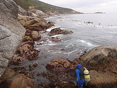 Diver preparing to enter the water at Finlay's Point


See
editMarine life
editKelp forests on the inshore rocks, and a wide variety of invertebrates living on the rocks.
The swimthroughs to the north under the 3-rock group are very colourful, with a wide range of bryozoans, sponges, colonial ascidians, anemones and other encrusting sea life. Outside the swimthroughs where there is more light, there is a lot of seaweed.
Fish life is variable, you may see large shoals of Fransmadam or Hottentot, and there are usually some Roman, Janbruin, Blacktail and other reef fish around. Bank steenbras have been seen at the pinnacle.
There are fair numbers of gorgonian sea fans on the deeper reefs, and, as usual, the shallower areas are densely covered in red-bait.
 These echinoderms are typical of False Bay reef cover
 A sponge on the reef
 Reef cover of a different sort
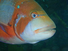 Roman
Roman Cape knifejaw
 Two tone fingerfin


Features
edit- Colourful shallow swimthroughs
- Inshore anchorage on sand
- Massive granite pinnacle
Photography
editGood site for small invertebrates, and probably also for reef fish..
Suggested Routes
edit- Anchor over the sandy patch in the lee of the big rocks. Dive at the boat, out to seaward among the rocks and boulders to 14m depth, work your way north a bit, then back inshore to north side of big rocks, then round to south at 3 to 5 m and surface over sandy patch.
- For a shore dive, swim out to the big rocks at the point, and on your way back spend some time in the swimthroughs under the 3-rock group.
- Put down a shotline at the pinnacle and dive around it, starting deep at about 18m and working your way back up to the top for the safety stop, where you have some reef to look at while you degas.
Stay safe
editHazards
editThere are no recorded site specific hazards. The path to the road may be even more slippery when wet, as the ground is largely weathered granite saprolith, and contains clay.
Skills
editNo special skills required. The site is suitable for novices. Some fitness and agility is recommended for shore entry.
Equipment
editNo special equipment required.
Nearby
edit
- 1 Graeme's Spot and The Jambles
- 2 Finlay's Pinnacle
- 3 Carnaby Street Pinnacle
- 4 Finlay's Deep
- 5 Atlantis Reef
- 6 Sherwood Forest
- 7 Partridge Point - Big Rock
Back to the Alphabetical list of sites, or list of dive sites in the Finlay's Point to Partridge Point area
Other regional dive sites:
- Dive sites of Table Bay and approaches,
- Dive sites of the Cape Peninsula west coast
- Dive sites of False Bay offshore and approaches
- Dive sites of False Bay east coast
- Fresh water dive sites of the Cape Town Metropolitan Area