Diving the MV ''Katsu Maru''

The dive site M.V. Katsu Maru is a recent wreck in the Hout Bay area on the Atlantic seaboard of the Cape Peninsula, near Cape Town in the Western Cape province of South Africa.
Understand
edit

Position
edit- 1 Bow of the Katsu Maru: S34°03.917’ E018°20.957’
- 2 MFV Katsu Maru wreck: S34°03.910’ E018°20.942’ — (roughly midships on the hull)
- 3 Stern of the Katsu Maru: S34°03.904’ E018°20.928’
In the middle of the mouth of Hout Bay, About parallel to and 30 m to the west of the wreck of the M.V. Aster
This site is in a Marine Protected Area (2004). A permit is required.
Name
editOn the evening of 8th July 1978, the Japanese trawler Katsu Maru #25 was sailing in thick fog 22 nm West of Slangkop Lighthouse, when it was in collision with the 18,600 ton Norwegian tanker Team Pollux . The Katsu Maru was holed on the port side near the stern and the engine room was flooded. Immediately after the collision, Team Pollux launched a lifeboat which picked up the 21 man crew of the fishing vessel.
The salvage tug Agulhas was dispatched from Cape Town and towed the Katsu Maru #25 towards Hout Bay. As the tow entered the bay, the Katsu Maru started to sink but was towed to the beach and sank in a few metres of water.
Over the next few weeks, the Katsu Maru #25 was surveyed and it was found that the cost of repairs exceeded the insurance value of the hull. It was then decided to tow the vessel 35 nm offshore and sink it in deep water.
On 7th Aug 1978, the Katsu Maru was towed off the beach by the Agulhas, but while leaving the bay the tow parted and the stern of the vessel sank to the seabed. After bobbing around for 2 days, the bow sank on the 9th August 1978.
Depth
editMaximum depth about 28 m meters in the scour at the bow and stern. The highest point of the wreck is at about 21.3 m depth.
Visibility
editVisibility will vary from pretty murky at about 2 m to really good at over 20 m. Good visibility is more likely after a strong south easterly wind, which may cause a local upwelling of clear bottom water from the open ocean nearby. The good visibility usually only lasts a few days, after which plankton bloom may reduce it again, particularly towards the surface.
Topography
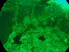
editThe hull is about 40 m long, and roughly 9 or 10 m beam, part of which is buried in the sand. The wreck lies on its starboard side heeled at slightly more than 90°, imbedded in the flat sand bottom at about 27 m depth. The bow points towards approximately magnetic south east. There is moderate scouring at bow and stern, usually to about 29 m maximum, depending on the tide. The superstructure deck appears to be buried almost to halfway, and the funnel is only just above the surface of the sand.
The hull is basically intact with a few holes rusted through, and still looks much like when it was afloat, but will probably deteriorate quite rapidly as the plating is getting very thin in places, and holes are appearing in the bottom and sides. The starboard side of the stern has wasted to about level with the flat surface of the sand, so if you go down the scour pit you will end up under or inside the hull. The stern deck areas are a bit cluttered with debris. There is an external bar keel about 150 mm deep along the length of the hull.
Interior:
There are a few places where access to the interior is reasonably practicable, though risk must be assessed by each diver on site as it will vary depending on skill and conditions.
The stern of the hull is accessible from the bottom of the aft scour pit, where the hull has rusted away. The interior in this area is a large compartment divided up by several structural components, including a small flat just below the deck (horizontal partial deck structure) The space is rather crowded by obstructions, but some movement is possible, though it may not be possible to turn around in some areas. The compartment appears to be connected through to other compartments further forward, but the space is very tight.
The side of the hull roughly level with the aft end of the superstructure has a large dent and the hull plating is torn, This hole is large enough to get into part of the machinery spaces, but the interior is very cramped and it does not look safe to go very far.
The wheelhouse is easily accessible by the door in the side of the superstructure, and the interior is reasonably clear, but the rest of the superstructure can be seen from there to be full of obstructions and snags, and there does not look like there are any alternative exits.
The main hold is easily accessible from the large hatch forward of the wheelhouse. this space is fairly large, and reasonably clear, and has numerous smaller openings to the outside, including holes in the bottom plating in the scour pit. The interior of the hold is reasonably clear and stable, but if a swell is running, the surge may cause strong flow through the holes, which could be dangerous.
The superstructure just forward of the main hatch has a door on the after bulkhead, which gives easy access to s fairly large and clear compartment with another access through a deck hatch leading to the outside near the level of the sand, The compartment is heavily silted. There is a fairly large and clear hatch leading into the hull in this compartment, but the space in the hull is fairly small, and there does not appear to be anything in it worth looking at.
The rest of the vessel is not easily accessible, if it is possible at all.
The wreck of the MV Aster lies to the north east of the Katsu Maru, at a distance of about 30 m.
Geology: Flat sand bottom.
Conditions
editThe site is exposed to south westerly swells, which can cause a strong surge. The site is usually at its best in summer but there are also occasional opportunities in autumn and winter.
This is an area which sometimes has upwellings, caused by strong south easterly winds, resulting in cold clear water, which may develop a plankton bloom over a few days, which will reduce the visibility again.
Keep a lookout for times when the south west swell is low and short period, and there is not too much south easterly wind forecast.
Get in
editAccess is only reasonably practicable by boat. The site is about a 2.2 km ride from the harbour slipway. The wreck is in the harbour approaches, and there may be significant boat traffic.
See
editMarine life
editThe wreck is heavily encrusted with common feather stars and sponges, with an exceptional display of Sunburst soft corals and some colonial ascidians and hydroids, and conger eels have been reported from the interior.
Encrusting invertebrates on the wreck include a yellow soft coral, white colonial ascidian, white tubular sponges, Multicolour sea fans, an orange encrusting sponge, beige fan sponges, Palmate sea fans, white nippled sea fans, brown encrusting sponge, Pustular tritons, orange feather duster worms, ribbed mussels, salmon pink encrusting sponge, arborescent bryozoans, stripe-mouthed squirts, brown trumpet sponges, Strawberry anemones, Striped anemone and Purple soft coral.
There are also 3-spot swimming crabs in sand and some large West coast rock lobster on the wreck.
 Feather stars and sunburst soft coral
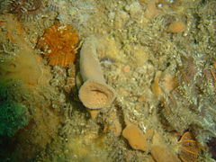 Brown tubular sponge
 Unusual white cup corals
 Palmate sea fan
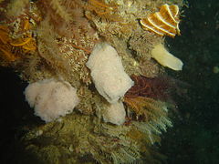 Small sponges
 Strawberry anemones
 Sunburst soft coral
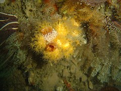 Yellow soft corals on a sea squirt
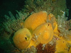 Yellow sponges


Features
editRecent wreck in fairly intact condition. The hull is said to provide challenging penetrations. The foredeck still has a large winch, and there are four gas cylinders on a rack.
 Gas cylinders at the aft end of the superstructure
 The midships port side of the superstructure
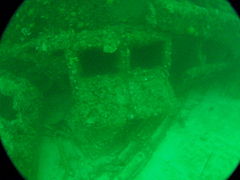 Engine room skylight forward of the funnel
 Foredeck of the Katsu Maru
 Wheelhouse side and front


Photography
editMacro and/or wide angle equipment recommended.
Routes
editMake your way to the nearest end of the wreck. move to the west side to the deck and superstructure and work your way along the wreck to the other end. There are a number of openings that you can look into, and in most cases a light will make a big difference in what you will see, as the hull is very dark inside.
From stern to bow the points of interest include: The quarterdeck, a group of high pressure gas cylinders near the funnel, a skylight for the engine room, a deep dent in the port side of the hull structure, a door into the superstructure on the port side, a door and window into the wheelhouse on the port side, a hatchway into the hold, a door into the forward superstructure and a hatchway to the same compartment, and a winch on the forecastle deck near the bow. The deck has more interesting details than the bottom. The sternpost is intact, with the stern gland for the propeller shaft clearly visible, but the rudder is missing.
Stay safe
editHazards
editCold water, occasional fog, boat traffic. Possible entrapment if the wreck is penetrated. Some of the structure may be unstable. Strong surge if the swell is large or the period long.
Skills
editNo special skills required unless penetration is intended. It is necessary to be qualified for 30m dives.
Equipment
editA light will restore colour and allow you to look into the wreck. Reel and DSMB are worth carrying in case it is necessary to surface away from the shotline. A dry-suit is recommended as the water is cold, Nitrox is recommended to extend no-decompression time. If you carry a compass, be aware that the mass of steel of the hulls distorts the local magnetic field, and directions will not be accurate within a few metres of the wreck.
Nearby
edit
Back to the Alphabetical list of sites, or list of dive sites in the Hout Bay area
Other regional dive sites:
- Dive sites of Table Bay and approaches
- Dive sites of the Cape Peninsula east coast
- Dive sites of False Bay offshore and approaches
- Dive sites of False Bay east coast
- Fresh water dive sites of the Cape Town Metropolitan Area