The dive site Moddergat is an offshore rocky reef in the Gordon's Bay area of False Bay, near Cape Town in the Western Cape province of South Africa.
Understand
editThis is a dive site which is close to the slipway at Harbour Island, and deep enough that the visibility at the bottom may be significantly better than in the shallower water of the shoreline dive sites of Gordon's Bay. It was known as a good fishing spot for many years, though the big fish are now more of a memory. It is similar to the dive site at Drop Zone which is about 6 km further west.
Position
edit- S34°09.150 E018°49.650 1 Moddergat:– Nominal position. This does not appear to be critical as the reef is quite large and quite flat.
This site is not in a Marine Protected Area. A permit is not required.
Name
editThe origin of the name is not clear. Moddergat means mudhole in Afrikaans, but there is no mud and it does not seem to be a hole, as the reef is higher than the surrounding sand bottom. There is a Moddergat river discharging into False Bay, but it is in Macassar, not near the dive site.
Depth
editMaximum depth is about 16 m at the sand edge to the north. It may be deeper to the south. The top of the reed is about 13 m. (Average depth is likely to be about 14 m.)
Visibility
editVisibility on the east side of False Bay is generally worse than on the Cape Peninsula, but Moddergat is just far enough offshore to be unaffected by most rain runoff and just deep enough to be relatively unaffected by swell, particularly as it is quite a large area without much silt. On the other hand, it will not have the advantage of upwelling clear water in an offshore wind and is exposed to the wind from all directions. Plankton blooms may reduce visibility in the upper layers while visibility at depth remains relatively good, though fairly dark. This can only be determined by diving. Visibility has been recorded up to about 10m, but will usually be less.
Topography
editModerate and low profile rocky reef with fairly high rugosity on the decimetre scale. The ridges and gullies are generally small and broken up. There are few, if any, landmarks of note.
Geology: Hard, resistant, sedimentary rock, possibly of the Precambrian Tygerberg formation. Strike and dip not obvious.
Conditions
editThe site is exposed to wind and chop from all directions, and swell from the south-west, so should be dived in low swell and light wind. The site is reasonably protected from south easterly swell, but if strong south easterly winds develop then the ride back to Gordon's Bay will be wet and bumpy, but fortunately not very long.
As of 2017, there is no preferred season for diving this site, local weather and ocean swell conditions will have the most influence. Avoid big southerly or south westerly swell.
Get in
editBoat access only, The site is a considerable distance offshore, and while it would be possible to find it with compass bearings, a GPS will be far more reliable.
The site is about 2.9 km from Harbour Island slipway, or 3.3 km from Gordon's Bay Old Harbour.
See
editMarine life
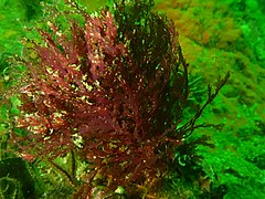
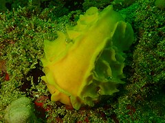
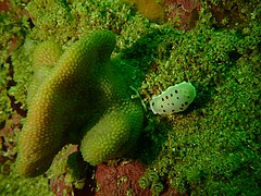
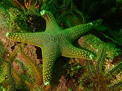
editThere is a fairly diverse invertebrate reef cover, with moderate densities of feather stars and brittlestars, but very few sea cucumbers. Moderate numbers of gorgonian sea fans, and quite a large number of small sponges. Small shoals of reef fish such as Hottentot and Panga, Redfingers, gobies, klipfish and small shysharks. Quite a few species of nudibranchs have been observed and photographed here. The site was known as a fishing spot by boat anglers, but has probably been fished out. The general area is rumoured to be in the cruising range of White sharks, but there don't appear to be any confirmed sightings by divers.
- Plocamium sp. red seaweed at Moddergat
- Small sponge at Moddergat
- Heathers' nudibranch Goniobranchus heatherae
- Small Puffadder shy shark Haploblepharus edwardsii
- Small perlemoen Haliotis midae
- Gasflame nudibranch Bonisa nakaza
- Grey starfish Callopatiria formosa
- Fiery nudibranch Okenia amoenula and egg ribbons
- Cape dorid Hypselodoris capensis
- Scribbled nudibrabch Doriopsilla miniata
Photography
editMacro equipment is most likely to get good results, as there are no spectacular features, and the visibility is likely to be limited. Artificial lighting recommended.
Suggested routes
editThe site is large, and no one area is greatly different from the others. Explore if it suits you, but there is no particular reason to go very far from the shotline.
Stay safe
editHazards
editGreat white sharks are said to cruise in the area, and some divers and skippers advise against decompression stops. This is not a big problem as an hour on air will generally not put you into deco. The choice not to do a safety stop is more a personal issue, depending on how you feel at the time. If the south-easterly wind comes up strongly during the dive it may be difficult for the boat crew to spot divers at the surface, and impossible to follow bubbles.
Skills
editNo special skills required. The site is shallow enough for entry level divers.
Equipment
editA DSMB will help the boat to find you while and after surfacing, specially if the wind comes up during the dive.
Nearby
editOther offshore dive sites of False Bay:
- 1 Choirboys Reef
- 2 Seal Island
- 3 Drop Zone
- 4 East Shoal
- 5 Sterretjies Reef
- 6 York Shoal
- 7 SAS Fleur
- 8 Offshore Barges – North Barge
- 9 Steenbras Deep - South Pinnacles
- 10 Blue Flame Pinnacles
- 11 SATS General Botha
- 12 Off-Whittle Ridge
- 13 SAS Bloemfontein
- 14 Whittle Rock
- 15 Bruce's Mark
- 16 Deep South Whittle Reef
- 17 SS Lusitania
- 18 Rocky Bank
Back to the Alphabetical list of sites, or list of reef dive sites in the northern False Bay offshore area
Other regional dive sites:
- Dive sites of Table Bay and approaches,
- Dive sites of the Cape Peninsula west coast
- Dive sites of the Cape Peninsula east coast
- Dive sites of False Bay east coast
- Fresh water dive sites of the Cape Town Metropolitan Area


