Diving the SS ''Umhlali''

The dive site SS Umhlali is an inshore rocky reef with historical wreck in the South Peninsula area on the Atlantic Seaboard of the Cape Peninsula, near Cape Town in the Western Cape province of South Africa.
Understand
editPosition
editName
editThe "SS Umhlali" is the name of the ship wrecked at this site. The SS Umhlali was a British registered steel cargo and passenger ship of 3380 gross registered tons, built at the Laing yard in Deptford in 1904 and wrecked on Albatross Rock on 15 September 1909. The ship was 106,1 long, 13,2 m beam and had a triple expansion steam engine.
Depth
editMaximum depth is about 8 or 9 m. and the top of the top of the reef is about 6 m.
Topography
editThe site is a moderate to low profile sandstone reef with widely scattered wreckage of a steel ship. The wreckage is heavily encrusted with corallines and other marine growth common in the area and most of the wreckage is very low and not easy to identify.
Geology: Ordovician sandstone of the Peninsula formation. It appears to be a hard rock, quite resistant to erosion, and the bedrock has quite a large number of boulders wedged into gaps, with smaller boulders and pebbles in the interstices. There is very little sand, and where it is present, it is possible that it covers specimens of the vessel's cargo which was washed into a crevice and settled there in the protected zone. Strike can not be determined on site, and dip is very flat.
Conditions
editThe site is exposed to swell and wind waves from the south west and north west, so should be dived in very low swell, and is often good in south easterly winds as long as they are not too strong. The site is reasonably protected from light south-easters, but if the swell picks up or the wind swings westerly then the conditions will rapidly become undiveable. The site is usually at it's best in spring summer and early autumn, but there are also occasional opportunities in winter. This is an area which sometimes has upwellings, caused by the south east wind, resulting in good visibility and cold water.
Get in
editThe site is only accessible by boat, as there are no roads providing reasonable shore access. It is 11.2 km from the slipway at the old crayfish factory north of Scarborough (Soetwater), about 17.1 km from the launch site at Kommetjie and 27.5 km from Hout Bay harbour slipway.
See
editMarine life
editThe reef is covered by a moderately dense kelp forest of both Sea bamboo and split fan kelp. The understorey in some places is bushy coralline algae, and the most exposed areas are generally covered by encrusting corallines. There are also large areas of low algal turfs of other kinds. The wreckage and crevices of the reef provide shelter for large numbers of West coast rock lobster, occasional rock crabs, scattered arborescent bryozoans, and some small sponges and colonial ascidians. Some of the relatively exposed surfaces have a dense and strongly adherent growth of larger solitary sea squirts, but these are significantly smaller than the usual red bait pods. These squirts provide a substrate for small seaweeds.
 West coast rock lobster and the brown arborescent bryozoan are very common at this site
 Kelp forests grow all over the site
 Heavy epiphyte growth on a kelp stipe


Features
editWreckage of a ship, and occasionally items of the cargo, which included small arms ammunition, large cartridges loaded with cordite, and mineral water bottles which were sealed with a captive glass ball
 Heavy cast iron bracket
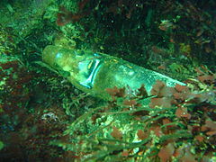 Old bottle with captive glass ball seal
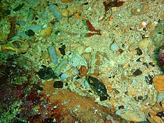 Lead bullets and shot in a crevice under the wreckage
 In places where the encrustation has been worn off the structure is more easily recognised


Photography
editThis is an area where there is not much to photograph unless you are a seaweed enthusiast, and even then, macro will usually give the best results, or if visibility is good and surge low, natural light wide angle shots.
Suggested Routes
editThe site is in dense kelp and usually in strong surge. There are no routes known, and your best bet is to move around at random and see what you can find. Look closely, as almost everything is tricky to recognise. the wreckage is astonishingly well camouflaged by the growth.
Stay safe
editHazards
editDense kelp may make surface swims difficult, particularly if you are low on air and have no snorkel. Keep enough gas to swim back to the boat underwater if it is anchored. Some of the wreckage has rusted to sharp points and edges. These could be dangerous in a strong surge if you are not careful.
Skills
editNo special skills required. The site is also suitable for snorkelling as it is mostly about 7 m deep.
Equipment
editNo special equipment recommended.
Nearby
edit
Back to the Alphabetical list of sites, or list of dive sites in the Atlantic South Peninsula area
Other regional dive sites:
- Dive sites of Table Bay and approaches
- Dive sites of the Cape Peninsula east coast
- Dive sites of False Bay offshore and approaches
- Dive sites of False Bay east coast
- Fresh water dive sites of the Cape Town Metropolitan Area