Diving at Sea Point Ridge Pinnacles

The dive site Sea Point Ridge Pinnacles is an offshore rocky reef in the Atlantic seaboard of the Cape Peninsula, near Cape Town in the Western Cape province of South Africa.
Understand
edit
The site is conveniently close to the slipway at Oceana Power Boat Club in Granger Bay, and is shallow enough for advanced recreational divers. It may be the closest granite offshore pinnacle to the slipway. The area is fairly well protected from south easterly winds.
Position
editName
editThe name "Sea Point Ridge Pinnacles" is a simple geographic description. The nearest landmark on the shore is Sea Point (after which the suburb on the mountainside is also named), and a low ridge extends out along the seabed in a north westerly direction. There is one high spot marked on the chart at the pinnacles.
Depth
editMaximum depth is about 27 m, and the top of the outer pinnacle is about 17 m. (Average depth is likely to be about 24 m.
Visibility
editVisibility will vary depending on the season and recent weather conditions. In summer after a strong south easterly wind and upwelling, it may be as good as 20 m. Visibility may also vary significantly with depth. After an upwelling and algal bloom, surface visibility may be as low as 2 to 3 m, while below the thermocline it may open up to more than 15 m, though it may be fairly dark.
Topography
editThe bottom in this area is low flat rock reef. The pinnacles are the only interruption of note in a large area, and they rise up from the bedrock at about 25 m almost vertically to about 18 m, and are fairly flat topped.
Geology: Pre-cambrian granite of the Peninsula pluton. The pinnacles may be quite near to the contact zone between the Peninsula pluton and the older Tygerberg formation, which is exposed at the shoreline just north of Sea Point.
Conditions
editThe site is exposed to wind and waves from the north west to the south west, so should be dived when the westerly swells are low, and is often good after strong south easterly winds, which reduce the swell and may bring clear, cold, nutrient rich water to the surface. The site is reasonably protected from south easterly winds, and very well protected from south easterly swell, but if a cold front moves in then conditions will deteriorate rapidly.
The site is usually at it's best in summer but there are also occasional opportunities at other times of the year.
This is an area which sometimes has upwellings, caused by the south-easterly winds, resulting in clear cold water, which will usually develop a plankton bloom over the next few days which will reduce surface visibility significantly. This site is deep enough that visibility at depth may differ significantly from at the surface.
Get in
editThis site is only accessible by boat, as it is nearly 2 km offshore. It is about 6.6 km from the Oceana Power Boat Club slipway at Granger Bay.
There are day charter boats which can take a diver to any of the dive sites in the region, but most operators only work from a limited number of launch sites, which limits the dive sites they visit. Visits to a dive site also depend on the weather and are generally not predictable or bookable more than two to four days in advance. See the listing for Cape Peninsula and False Bay boat dive charters and the associated services directory for contact details.
See
editMarine life
editThe tops of the pinnacles have sparse Laminaria kelp forests, and the upper parts of the sides were heavily encrusted with small black mussel in November 2011. Lower down there are sea urchins, strawberry anemones and scattered sponges and colonial ascidians.
 Black mussels and anemones on the pinnacle walls
 Tubeworms
 Urchins and brittle stars
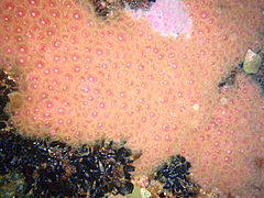 Two colour morphs of strawberry anemone
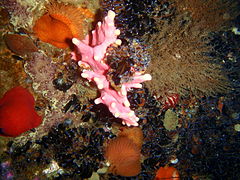 Assorted reef life at the pinnacle
 Grey fan hydroid


Features
editThe main feature of the site is the pair of pinnacles on a relatively level base.
Photography
editIf the water is clear all the way down, wide angle natural light photos should turn out well, but you are more likely to be successful with macro equipment.
Suggested Routes
editThe site is small, and can be visited on a single dive. Start at the main pinnacle, which is where the shot should be, and swim around it. Make an excursion across the bottom to see if you can find anything interesting, and return to the shotline for ascent, or use a DSMB to mark your position.
Stay safe
editHazards
editThere are no known site-specific hazards. The shipping lanes are to seaward of the site, and only small craft are likely to pass nearby.
Skills
editNo special skills required, the site is too deep for open water divers, and buoyancy control should be good enough to surface without a visible reference
Equipment
editThe water is usually cold. A thick wet suit or a dry suit is recommended. Nitrox can significantly extend no-stop dive time if you are warm enough, and a DSMB is useful if you have to surface away from the shotline.
Nearby
edit
- 1 MV Gemsbok
- 2 Highfields
- 3 SS SA Seafarer
- 4 SS Cape Matapan
- 5 RMS Athens
- 6 Three Anchor Bay
- 7 Two Oceans Aquarium
- 8 Bantry Bay
- 9 North Lion’s Paw Main Reef
- 10 South Lion’s Paw
- 11 Clifton Rocks
- 12 Cleeve's Tunnel
- 13 Bakoven Rock
- 14 Dreadlocks Reef
Back to the Alphabetical list of sites, or list of dive sites in the Sea Point area
Other regional dive sites:
- Dive sites of the Cape Peninsula west coast
- Dive sites of the Cape Peninsula east coast
- Dive sites of False Bay offshore and approaches
- Dive sites of False Bay east coast
- Fresh water dive sites of the Cape Town Metropolitan Area