File:Africa independence dates.PNG

Size of this preview: 564 × 600 pixels. Other resolutions: 226 × 240 pixels | 451 × 480 pixels | 752 × 800 pixels.
Original file (752 × 800 pixels, file size: 42 KB, MIME type: image/png)
This is a file from the Wikimedia Commons and may be used by other projects. Information from its description page there is shown below.
Commons is a freely licensed media file repository. |

|
File:Africa independence dates.svg is a vector version of this file. It should be used in place of this PNG file when not inferior.
File:Africa independence dates.PNG → File:Africa independence dates.svg
For more information, see Help:SVG. |
 |
Summary
Español: Fechas de independencia de los países africanos.
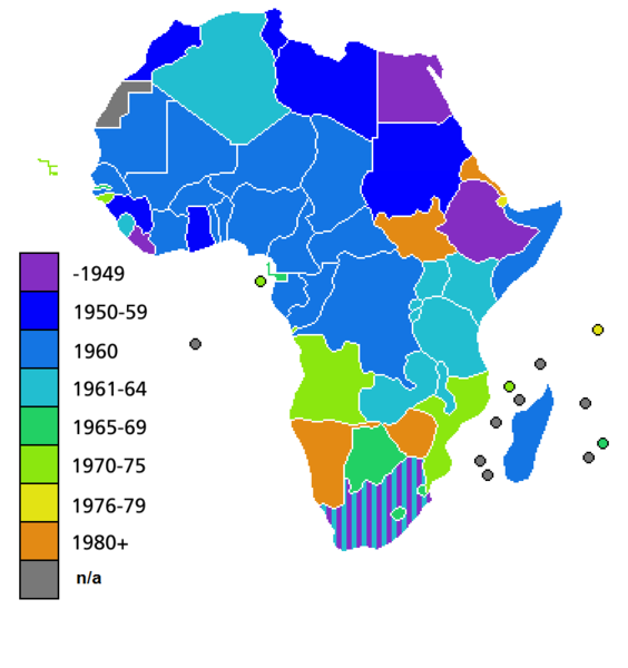
Countries of Africa, with date of independence
Licensing

|
Permission is granted to copy, distribute and/or modify this document under the terms of the GNU Free Documentation License, Version 1.2 or any later version published by the Free Software Foundation; with no Invariant Sections, no Front-Cover Texts, and no Back-Cover Texts. A copy of the license is included in the section entitled GNU Free Documentation License. |
| This file is licensed under the Creative Commons Attribution-Share Alike 3.0 Unported license. | ||
| ||
| This licensing tag was added to this file as part of the GFDL licensing update. |
File history
Click on a date/time to view the file as it appeared at that time.
| Date/Time | Thumbnail | Dimensions | User | Comment | |
|---|---|---|---|---|---|
| current | 04:25, 9 July 2011 | | 752 × 800 (42 KB) | Hoshie | added South Sudan to the map |
| 02:34, 19 June 2011 |  | 752 × 800 (42 KB) | Muso | Reverted to version as of 10:09, 22 April 2011 | |
| 02:19, 19 June 2011 |  | 752 × 800 (14 KB) | Muso | Zimbabwe got his independence in 1965, therefore correct its color from orange green | |
| 10:09, 22 April 2011 |  | 752 × 800 (42 KB) | Hoshie | added the French departements of Mayotte and Reunion and the Ilies Eparses distict of the TAAF; CIA maps was used as a source. A version w/ Southern Sudan is ready for July. | |
| 03:00, 11 April 2011 |  | 752 × 800 (42 KB) | Hoshie | added Cabinda (Angola) to the map; a version with Southern Sudan is ready once they declare independence in July. | |
| 18:16, 6 April 2010 |  | 752 × 800 (38 KB) | Lemonade100 | De Jure Independance of Zimbawe and South Africa (changed from de facto), St Helena and dependancies added. | |
| 01:35, 23 March 2008 |  | 752 × 690 (36 KB) | Serg!o | UN considers Sahara as a colony - ONU considera Sahara como colonia | |
| 11:44, 22 March 2006 |  | 752 × 690 (36 KB) | Roke~commonswiki | Countries of Africa, with date of independence Category: Maps of Africa Category: History of Africa |
File usage
There are no pages that use this file.
Global file usage
The following other wikis use this file:
- Usage on bn.wikipedia.org
- Usage on el.wikivoyage.org
- Usage on en.wikipedia.org
- Usage on hi.wikipedia.org