File:Agfr map.jpg

Size of this preview: 450 × 600 pixels. Other resolutions: 180 × 240 pixels | 550 × 733 pixels.
Original file (550 × 733 pixels, file size: 85 KB, MIME type: image/jpeg)
This is a file from the Wikimedia Commons and may be used by other projects. Information from its description page there is shown below.
Commons is a freely licensed media file repository. |
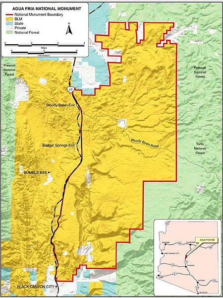
| Description | map of Agua Fria National Monument, in the the Sonoran Desert, Arizona. | |||
| Source | official website: http://www.blm.gov/az/aguafria/pmesa.htm | |||
| Author | BLM map | |||
| Permission (Reusing this file) |
|
File history
Click on a date/time to view the file as it appeared at that time.
| Date/Time | Thumbnail | Dimensions | User | Comment | |
|---|---|---|---|---|---|
| current | 16:01, 19 March 2007 | | 550 × 733 (85 KB) | H-stt | {{Information |Description= map of Agua Fria National Monument, Arizona |Source= official website http://www.blm.gov/az/aguafria/pmesa.htm |Date= |Author= BLM map |Permission= {{PD-USGov-BLM}} |other_versions= }} Category:Agua Fria National Monument |
File usage
The following page uses this file:
Global file usage
The following other wikis use this file:
- Usage on de.wikipedia.org