File:Anne Beadell Highway 0116.svg

Size of this PNG preview of this SVG file: 800 × 350 pixels. Other resolutions: 320 × 140 pixels | 640 × 280 pixels | 1,024 × 448 pixels | 1,280 × 560 pixels | 2,560 × 1,120 pixels | 1,072 × 469 pixels.
Original file (SVG file, nominally 1,072 × 469 pixels, file size: 77 KB)
This is a file from the Wikimedia Commons and may be used by other projects. Information from its description page there is shown below.
Commons is a freely licensed media file repository. |
Summary
This vector image was created with Inkscape .
| Description |
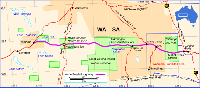
English: Map of the Anne Beadell Highway in Australia. The original section built by Len Beadell was from Mabel Creek Station to the Lake Yeo area. |
| Date | |
| Source | Own work |
| Author | Summerdrought |
Licensing
I, the copyright holder of this work, hereby publish it under the following license:
This file is licensed under the Creative Commons Attribution-Share Alike 4.0 International license.
- You are free:
- to share – to copy, distribute and transmit the work
- to remix – to adapt the work
- Under the following conditions:
- attribution – You must give appropriate credit, provide a link to the license, and indicate if changes were made. You may do so in any reasonable manner, but not in any way that suggests the licensor endorses you or your use.
- share alike – If you remix, transform, or build upon the material, you must distribute your contributions under the same or compatible license as the original.
File history
Click on a date/time to view the file as it appeared at that time.
| Date/Time | Thumbnail | Dimensions | User | Comment | |
|---|---|---|---|---|---|
| current | 22:20, 22 January 2017 | | 1,072 × 469 (77 KB) | Summerdrought | Map details and roads as at 1972. Added Gunbarrel Highway, removed Ilkurlka, removed road through Ilkurlka and north-east of Warburton. |
| 20:29, 23 February 2016 |  | 1,072 × 469 (50 KB) | Summerdrought | fix alignment of GCR | |
| 21:41, 31 January 2016 |  | 1,072 × 469 (49 KB) | Summerdrought | road section laverton to yamarna altered to red from purple | |
| 21:23, 31 January 2016 |  | 1,072 × 469 (49 KB) | Summerdrought | add lakes (throssell & yeo) magnifiy a road | |
| 15:56, 30 January 2016 |  | 1,072 × 469 (38 KB) | Perhelion | fix lake (self-inflicted) // Editing SVG source code using User:Rillke/SVGedit.js; upload handled by User:Rillke/MwJSBot.js | |
| 15:48, 30 January 2016 |  | 1,072 × 469 (38 KB) | Perhelion | semi text → path again | |
| 15:23, 30 January 2016 |  | 1,072 × 469 (34 KB) | Perhelion | ups* fix height | |
| 15:17, 30 January 2016 |  | 700 × 306 (34 KB) | Perhelion | fix bug phab:T32033 (rotated text the real text) | |
| 01:08, 30 January 2016 |  | 1,073 × 469 (55 KB) | Perhelion | fixed bug phab:T117530 on request | |
| 02:29, 28 January 2016 |  | 1,072 × 469 (162 KB) | Summerdrought | removed xml error |
File usage
The following page uses this file:
Global file usage
The following other wikis use this file:
- Usage on de.wikipedia.org
- Usage on de.wikivoyage.org
- Usage on en.wikipedia.org
- Usage on www.wikidata.org