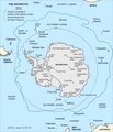
File:Antarctic-Convergence-Map.TIF

Size of this PNG preview of this TIF file: 514 × 600 pixels. Other resolutions: 206 × 240 pixels | 411 × 480 pixels | 658 × 768 pixels | 878 × 1,024 pixels | 2,373 × 2,768 pixels.
Original file (2,373 × 2,768 pixels, file size: 898 KB, MIME type: image/tiff)
File history
Click on a date/time to view the file as it appeared at that time.
| Date/Time | Thumbnail | Dimensions | User | Comment | |
|---|---|---|---|---|---|
| current | 09:20, 27 November 2022 |  | 2,373 × 2,768 (898 KB) | Apcbg | style |
| 19:03, 26 November 2022 |  | 2,373 × 2,768 (898 KB) | Apcbg | typo fixed | |
| 10:30, 13 August 2014 |  | 2,373 × 2,768 (980 KB) | Apcbg | Alexander Island | |
| 12:16, 12 August 2014 |  | 2,373 × 2,768 (978 KB) | Apcbg | {{Information |Description=Map of the Antarctic Convergence. |Source=Ivanov, L. and N. Ivanova. Antarctic: Nature, History, Utilization, Geographic Names and Bulgarian Participation. Sofia: Manfred Wörner Foundation, 2014. p. 9 (in Bulgarian) ISBN 97... |
File usage
The following page uses this file:
Global file usage
The following other wikis use this file:
- Usage on bg.wikipedia.org
- Usage on de.wikipedia.org
- Usage on en.wikipedia.org
- Usage on es.wikipedia.org
- Usage on eu.wikipedia.org
- Usage on fa.wikipedia.org
- Usage on id.wikipedia.org
- Usage on ko.wikipedia.org
- Usage on lb.wikipedia.org
- Usage on lt.wikipedia.org
- Usage on mk.wikipedia.org
- Usage on ru.wikipedia.org
- Usage on uk.wikipedia.org
- Usage on www.wikidata.org

