File:Bukoba View.JPG

Size of this preview: 800 × 533 pixels. Other resolutions: 320 × 213 pixels | 640 × 427 pixels | 1,024 × 683 pixels | 1,280 × 853 pixels | 1,536 × 1,024 pixels.
Original file (1,536 × 1,024 pixels, file size: 579 KB, MIME type: image/jpeg)
This is a file from the Wikimedia Commons and may be used by other projects. Information from its description page there is shown below.
Commons is a freely licensed media file repository. |
Summary
| Camera location | | View this and other nearby images on: OpenStreetMap |
|---|
Licensing
| |
This work has been released into the public domain by its author, AnderssDK, at the English Wikipedia project. This applies worldwide. In case this is not legally possible: |
Original upload log
The original description page was here. All following user names refer to en.wikipedia.
Transferred from en.wikipedia; transferred to Commons by User:QuiteUnusual using CommonsHelper.
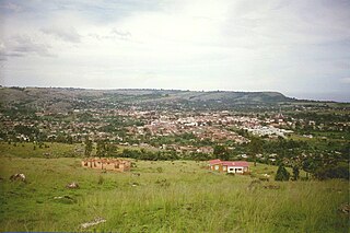
- 2008-01-22 08:52 AnderssDK 1536×1024× (592811 bytes) {{Information |Description=View of Bukoba |Source=self-made |Date=27.nov 2002 |Location=Bukoba |Author=Anders S |Permission= |other_versions= }}
File history
Click on a date/time to view the file as it appeared at that time.
| Date/Time | Thumbnail | Dimensions | User | Comment | |
|---|---|---|---|---|---|
| current | 21:22, 5 January 2009 | | 1,536 × 1,024 (579 KB) | MarcGarver | {{Information |Description={{en|View of Bukoba}} |Source=Transferred from [http://en.wikipedia.org en.wikipedia]; transferred to Commons by User:QuiteUnusual using [http://tools.wikimedia.de/~magnus/commonshelper.php CommonsHelper].<br/> (Original tex |
File usage
The following page uses this file:
Global file usage
The following other wikis use this file:
- Usage on azb.wikipedia.org
- Usage on be.wikipedia.org
- Usage on bg.wikipedia.org
- Usage on de.wikipedia.org
- Usage on en.wikipedia.org
- Usage on es.wikipedia.org
- Usage on et.wikipedia.org
- Usage on fa.wikipedia.org
- Usage on fi.wikipedia.org
- Usage on fr.wikipedia.org
- Usage on gag.wikipedia.org
- Usage on hr.wikipedia.org
- Usage on hy.wikipedia.org
- Usage on it.wikipedia.org
- Usage on it.wikivoyage.org
- Usage on ja.wikipedia.org
- Usage on ko.wikipedia.org
- Usage on lt.wikipedia.org
- Usage on mt.wikipedia.org
- Usage on nl.wikipedia.org
- Usage on pl.wikipedia.org
- Usage on pt.wikipedia.org
- Usage on ro.wikipedia.org
- Usage on ru.wikipedia.org
- Usage on ru.wikivoyage.org
- Usage on sv.wikipedia.org
- Usage on sw.wikipedia.org
- Usage on tr.wikipedia.org
- Usage on uk.wikipedia.org
- Usage on ur.wikipedia.org
- Usage on vi.wikipedia.org
- Usage on zu.wikipedia.org