File:Carte Métro de Paris.jpg
Size of this preview: 786 × 600 pixels. Other resolutions: 315 × 240 pixels | 629 × 480 pixels | 1,007 × 768 pixels | 1,280 × 976 pixels | 2,560 × 1,953 pixels | 3,765 × 2,872 pixels.
Original file (3,765 × 2,872 pixels, file size: 2.19 MB, MIME type: image/jpeg)
This is a file from the Wikimedia Commons and may be used by other projects. Information from its description page there is shown below.
Commons is a freely licensed media file repository. |

|
This file requires updating. Please see the talk page for more information. In doing so, you could add a timestamp to the file.
|
Summary
| Description |
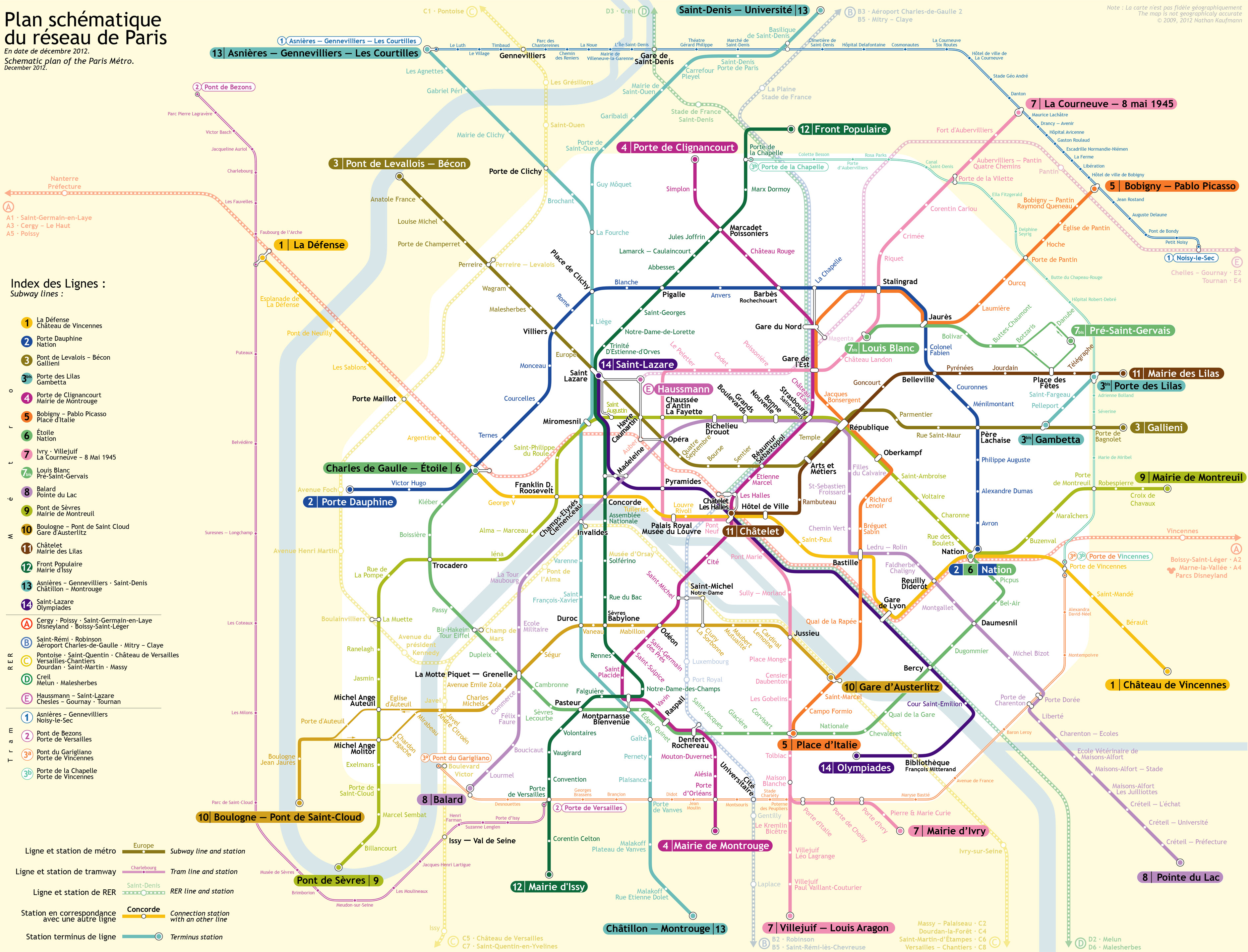
English: Network map of the Paris Métro
Français : Plan du métro de Paris |
| Source | Own work |
| Author | Rigil |
| Other versions | Network maps of the Paris Metro |
Licensing
I, the copyright holder of this work, hereby publish it under the following licenses:

|
Permission is granted to copy, distribute and/or modify this document under the terms of the GNU Free Documentation License, Version 1.2 or any later version published by the Free Software Foundation; with no Invariant Sections, no Front-Cover Texts, and no Back-Cover Texts. A copy of the license is included in the section entitled GNU Free Documentation License. |
This file is licensed under the Creative Commons Attribution 3.0 Unported license.
- You are free:
- to share – to copy, distribute and transmit the work
- to remix – to adapt the work
- Under the following conditions:
- attribution – You must give appropriate credit, provide a link to the license, and indicate if changes were made. You may do so in any reasonable manner, but not in any way that suggests the licensor endorses you or your use.
You may select the license of your choice.
File history
Click on a date/time to view the file as it appeared at that time.
| Date/Time | Thumbnail | Dimensions | User | Comment | |
|---|---|---|---|---|---|
| current | 20:58, 25 July 2013 | | 3,765 × 2,872 (2.19 MB) | Rigil~commonswiki | T3a |
| 10:09, 20 August 2012 |  | 3,765 × 2,872 (4.77 MB) | Rigil~commonswiki | Mise à jour | |
| 11:00, 26 October 2010 |  | 3,765 × 2,760 (3.01 MB) | Rigil~commonswiki | Taille x0.5 | |
| 10:56, 26 October 2010 |  | 7,530 × 5,519 (10.99 MB) | Rigil~commonswiki | Amélioration de la lisibilité (autour du secteur Saint-Lazare). Petites modifications par anticipation aux futures cartes avec les extensions des lignes 4,8 et 12 prévues. | |
| 20:10, 22 December 2009 |  | 3,765 × 2,760 (1.68 MB) | Rigil~commonswiki | Corrections de coquilles. Amélioration de la lisibilité. | |
| 14:22, 25 November 2009 |  | 3,765 × 2,760 (2.02 MB) | Rigil~commonswiki | Améliorations générales / Lisibilité. | |
| 17:34, 7 November 2009 |  | 7,530 × 5,259 (10.74 MB) | Rigil~commonswiki | {{Information |Description={{en|1=Network map of the Paris Métro}} {{fr|1=Plan du métro de Paris}} |Source={{own}} |Author=Rigil |Date= |Permission= |other_versions= }} Category:Paris |
File usage
The following page uses this file:
Global file usage
The following other wikis use this file:
- Usage on af.wikipedia.org
- Usage on an.wikipedia.org
- Usage on ar.wikipedia.org
- Usage on az.wikipedia.org
- Usage on be-tarask.wikipedia.org
- Usage on be.wikipedia.org
- Usage on bg.wikipedia.org
- Usage on bn.wikipedia.org
- Usage on ca.wikipedia.org
- Usage on da.wikipedia.org
- Usage on de.wikipedia.org
- Usage on de.wikivoyage.org
- Usage on en.wikipedia.org
- Usage on eo.wikipedia.org
- Usage on es.wikipedia.org
- Usage on es.wikivoyage.org
- Usage on eu.wikipedia.org
- Usage on fa.wikipedia.org
- Usage on fr.wikipedia.org
- Usage on fr.wikivoyage.org
- Usage on gan.wikipedia.org
- Usage on ga.wikipedia.org
- Usage on gl.wikipedia.org
- Usage on he.wikipedia.org
- Usage on hr.wikipedia.org
- Usage on hu.wikipedia.org
- Usage on hy.wikipedia.org
- Usage on id.wikipedia.org
- Usage on it.wikipedia.org
- Usage on it.wikivoyage.org
- Usage on ka.wikipedia.org
- Usage on ku.wikipedia.org
- Usage on la.wikipedia.org
- Usage on lmo.wikipedia.org
View more global usage of this file.