File:Central City map.png

Size of this preview: 340 × 598 pixels. Other resolutions: 136 × 240 pixels | 272 × 480 pixels | 436 × 768 pixels | 582 × 1,024 pixels | 1,709 × 3,008 pixels.
Original file (1,709 × 3,008 pixels, file size: 1.63 MB, MIME type: image/png)
This is a file from the Wikimedia Commons and may be used by other projects. Information from its description page there is shown below.
Commons is a freely licensed media file repository. |
Summary
| Description |
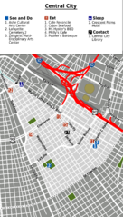
English: Central City map. English version, New Orleans. |
| Date | |
| Source | Central City_map.svg |
| Author | Peter Fitzgerald, OpenStreetMap [1] |

|
File:Central City map.svg is a vector version of this file. It should be used in place of this PNG file when not inferior.
File:Central City map.png → File:Central City map.svg
For more information, see Help:SVG. |
 |
Licensing
This file is licensed under the Creative Commons Attribution-Share Alike 2.0 Generic license.
- You are free:
- to share – to copy, distribute and transmit the work
- to remix – to adapt the work
- Under the following conditions:
- attribution – You must give appropriate credit, provide a link to the license, and indicate if changes were made. You may do so in any reasonable manner, but not in any way that suggests the licensor endorses you or your use.
- share alike – If you remix, transform, or build upon the material, you must distribute your contributions under the same or compatible license as the original.
Original upload log
| This file was imported from Wikivoyage WTS. |
The original description page was here. All following user names refer to wts.wikivoyage-old.
- 2011-06-10 04:26 (WT-shared) Peterfitzgerald archive copy at the Wayback Machine 1709×3008 (1708323 bytes) == Summary == {{Imagecredit|credit=Peter Fitzgerald, OpenStreetMap [http://www.openstreetmap.org/]|captureDate=9 June 2011|location=New Orle (Import from wikitravel.org/shared)
File history
Click on a date/time to view the file as it appeared at that time.
| Date/Time | Thumbnail | Dimensions | User | Comment | |
|---|---|---|---|---|---|
| current | 23:07, 17 November 2012 | | 1,709 × 3,008 (1.63 MB) | MGA73bot2 | {{BotMoveToCommons|wts.oldwikivoyage|year={{subst:CURRENTYEAR}}|month={{subst:CURRENTMONTHNAME}}|day={{subst:CURRENTDAY}}}} == {{int:filedesc}} == {{Information |description=Central City map. English version, New Orleans * Map of: New Orleans¤ |date=9... |
File usage
The following page uses this file: