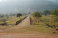
File:Champassak.- Panorama of Vat Phou (3).jpg

Original file (3,824 × 2,869 pixels, file size: 2.91 MB, MIME type: image/jpeg)
This is a file from the Wikimedia Commons and may be used by other projects. Information from its description page there is shown below.
Commons is a freely licensed media file repository. |
Summary
| DescriptionChampassak.- Panorama of Vat Phou (3).jpg |
English: Alley lined with twisted Plumeria (Frangipani) tree trunk overgrowing the ruins of the crooked, steep stone stairs, covered of moss, of Wat Phou Khmer temple, nouned world heritage by UNESCO, Champasak, Laos. To the east of the sanctuary, halfway up the mountain, extends the roadway of the temple bordered by two large excavated reservoirs (barays).
Français : Allée bordée de troncs d'arbres Plumeria (frangipanier) tordus et penchés, recouvrant les ruines de l'escalier difforme et escarpé, couvert de mousse, du temple Khmer Wat Phou, classé au patrimoine mondial de l'UNESCO, à Champassak, au Laos. A l'est du sanctuaire, à mi-hauteur de la montagne, s'étend la chaussée du temple bordée par deux grands réservoirs excavés (barays ). |
||||||||||||||||||||
| Date | |||||||||||||||||||||
| Source | Own work | ||||||||||||||||||||
| Author |
creator QS:P170,Q97949455 |
||||||||||||||||||||
| Permission (Reusing this file) |
|
||||||||||||||||||||
| Other versions |
   |
||||||||||||||||||||
| Camera location | 14° 50′ 53.75″ N, 105° 49′ 03.36″ E | View this and other nearby images on: OpenStreetMap |
|---|
Licensing

|
Permission is granted to copy, distribute and/or modify this document under the terms of the GNU Free Documentation License, Version 1.2 or any later version published by the Free Software Foundation; with no Invariant Sections, no Front-Cover Texts, and no Back-Cover Texts. A copy of the license is included in the section entitled GNU Free Documentation License.http://www.gnu.org/copyleft/fdl.htmlGFDLGNU Free Documentation Licensetruetrue |
- You are free:
- to share – to copy, distribute and transmit the work
- to remix – to adapt the work
- Under the following conditions:
- attribution – You must give appropriate credit, provide a link to the license, and indicate if changes were made. You may do so in any reasonable manner, but not in any way that suggests the licensor endorses you or your use.
- share alike – If you remix, transform, or build upon the material, you must distribute your contributions under the same or compatible license as the original.

|
This image has been assessed using the Quality image guidelines and is considered a Quality image.
العربية ∙ جازايرية ∙ беларуская ∙ беларуская (тарашкевіца) ∙ български ∙ বাংলা ∙ català ∙ čeština ∙ Cymraeg ∙ Deutsch ∙ Schweizer Hochdeutsch ∙ Zazaki ∙ Ελληνικά ∙ English ∙ Esperanto ∙ español ∙ eesti ∙ euskara ∙ فارسی ∙ suomi ∙ français ∙ galego ∙ עברית ∙ हिन्दी ∙ hrvatski ∙ magyar ∙ հայերեն ∙ Bahasa Indonesia ∙ italiano ∙ 日本語 ∙ Jawa ∙ ქართული ∙ 한국어 ∙ kurdî ∙ Lëtzebuergesch ∙ lietuvių ∙ македонски ∙ മലയാളം ∙ मराठी ∙ Bahasa Melayu ∙ Nederlands ∙ Norfuk / Pitkern ∙ polski ∙ português ∙ português do Brasil ∙ rumantsch ∙ română ∙ русский ∙ sicilianu ∙ slovenčina ∙ slovenščina ∙ shqip ∙ српски / srpski ∙ svenska ∙ தமிழ் ∙ తెలుగు ∙ ไทย ∙ Tagalog ∙ Türkçe ∙ toki pona ∙ українська ∙ vèneto ∙ Tiếng Việt ∙ 中文 ∙ 中文(简体) ∙ 中文(繁體) ∙ +/− |
Captions
Items portrayed in this file
depicts
some value
14°50'53.750"N, 105°49'3.360"E
24 January 2014
image/jpeg
a52aa81adbf8176a7384816491713a8b289be2ee
3,048,786 byte
2,869 pixel
3,824 pixel
0.004 second
55 millimetre
200
File history
Click on a date/time to view the file as it appeared at that time.
| Date/Time | Thumbnail | Dimensions | User | Comment | |
|---|---|---|---|---|---|
| current | 16:16, 28 December 2014 |  | 3,824 × 2,869 (2.91 MB) | Pierre André Leclercq |
File usage
The following page uses this file:
Metadata
This file contains additional information, probably added from the digital camera or scanner used to create or digitize it.
If the file has been modified from its original state, some details may not fully reflect the modified file.
| Camera manufacturer | SONY |
|---|---|
| Camera model | NEX-F3 |
| Exposure time | 1/250 sec (0.004) |
| F Number | f/9 |
| ISO speed rating | 200 |
| Date and time of data generation | 05:34, 24 January 2014 |
| Lens focal length | 55 mm |
| Orientation | Normal |
| Horizontal resolution | 350 dpi |
| Vertical resolution | 350 dpi |
| Software used | GIMP 2.8.10 |
| File change date and time | 17:09, 28 December 2014 |
| Y and C positioning | Co-sited |
| Exposure Program | Normal program |
| Exif version | 2.3 |
| Date and time of digitizing | 05:34, 24 January 2014 |
| Meaning of each component |
|
| Image compression mode | 3 |
| APEX brightness | 8.56796875 |
| APEX exposure bias | 0 |
| Maximum land aperture | 4.96875 APEX (f/5.6) |
| Metering mode | Pattern |
| Light source | Unknown |
| Flash | Flash did not fire, auto mode |
| Supported Flashpix version | 1 |
| Color space | sRGB |
| File source | Digital still camera |
| Scene type | A directly photographed image |
| Custom image processing | Normal process |
| Exposure mode | Auto exposure |
| White balance | Auto white balance |
| Digital zoom ratio | 1 |
| Focal length in 35 mm film | 82 mm |
| Scene capture type | Standard |
| Contrast | Normal |
| Saturation | Normal |
| Sharpness | Normal |


