File:Cy-map.png

No higher resolution available.
Cy-map.png (629 × 319 pixels, file size: 12 KB, MIME type: image/png)
This is a file from the Wikimedia Commons and may be used by other projects. Information from its description page there is shown below.
Commons is a freely licensed media file repository. |

|
This map image could be re-created using vector graphics as an SVG file. This has several advantages; see Commons:Media for cleanup for more information. If an SVG form of this image is available, please upload it and afterwards replace this template with
{{vector version available|new image name}}.
It is recommended to name the SVG file “Cy-map.svg”—then the template Vector version available (or Vva) does not need the new image name parameter. |
Summary
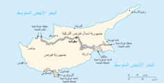
| Description | Cyprus map from CIA World Factbook, converted from original GIF format |
| Date | |
| Source | CIA World Factbook: Cyprus. Archived from the original on 3 June 2003. |
| Author | United States Central Intelligence Agency |
| Other versions |
|
Licensing
This image is in the public domain because it contains materials that originally came from the United States Central Intelligence Agency's World Factbook.
|
 |
Derivative works
-
 Cy-map-ger.png
Deutsch

-
 Arabic

File history
Click on a date/time to view the file as it appeared at that time.
| Date/Time | Thumbnail | Dimensions | User | Comment | |
|---|---|---|---|---|---|
| current | 20:30, 27 November 2004 | | 629 × 319 (12 KB) | Kneiphof | CIA Cyprus map |
File usage
The following page uses this file:
Global file usage
The following other wikis use this file:
- Usage on azb.wikipedia.org
- Usage on be.wikipedia.org
- Usage on ca.wikipedia.org
- Usage on ckb.wikipedia.org
- Usage on cs.wikinews.org
- Usage on de.wikipedia.org
- Usage on dsb.wikipedia.org
- Usage on en.wikipedia.org
- Cyprus
- Turkish invasion of Cyprus
- Greek junta
- Portal:Cyprus
- Greek New Zealanders
- United Nations Security Council Resolution 370
- United Nations Security Council Resolution 383
- United Nations Security Council Resolution 391
- United Nations Security Council Resolution 401
- United Nations Security Council Resolution 410
- United Nations Security Council Resolution 422
- United Nations Security Council Resolution 430
- United Nations Security Council Resolution 440
- United Nations Security Council Resolution 443
- Category:Populated places in Cyprus
- Talk:Grand Lodge of Cyprus
- Usage on eo.wikipedia.org
- Usage on fa.wikipedia.org
- Usage on fr.wikipedia.org
- Résolution 370 du Conseil de sécurité des Nations unies
- Résolution 383 du Conseil de sécurité des Nations unies
- Résolution 391 du Conseil de sécurité des Nations unies
- Résolution 401 du Conseil de sécurité des Nations unies
- Résolution 410 du Conseil de sécurité des Nations unies
- Résolution 422 du Conseil de sécurité des Nations unies
- Résolution 430 du Conseil de sécurité des Nations unies
View more global usage of this file.