File:Drumshanbo Lock on the Lough Allen Canal - geograph.org.uk - 798104.jpg
No higher resolution available.
Drumshanbo_Lock_on_the_Lough_Allen_Canal_-_geograph.org.uk_-_798104.jpg (640 × 480 pixels, file size: 76 KB, MIME type: image/jpeg)
This is a file from the Wikimedia Commons and may be used by other projects. Information from its description page there is shown below.
Commons is a freely licensed media file repository. |
Summary
| Description |
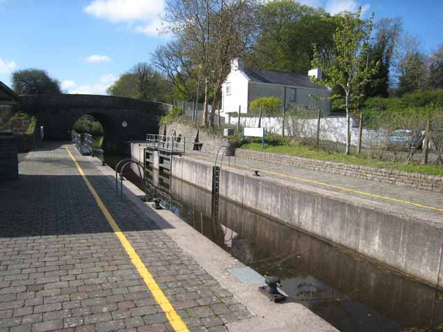
English: Drumshanbo Lock on the Lough Allen Canal The Lough Allen Canal was constructed 1818-1822 to carry commercial traffic from Lough Allen through to the Shannon at Battle Bridge near Leitrim village - primarily coal from the mines at Arigna (the River Shannon is too shallow immediately south of the Lough). Commercial traffic ceased in 1930 but the Canal was reopened for pleasure craft in 1970 and connects Lough Allen to the extensive Shannon Waterway system. http://www.waymarking.com/waymarks/WM3DA8 |
| Date | |
| Source | From geograph.org.uk |
| Author | Oliver Dixon |
| Attribution (required by the license) | Oliver Dixon / Drumshanbo Lock on the Lough Allen Canal / |
| Camera location | | View this and other nearby images on: OpenStreetMap |
|---|
_heading:180.00&language=en)
| Object location | | View this and other nearby images on: OpenStreetMap |
|---|
_heading:180.00&language=en)
Licensing

|
This image was taken from the Geograph project collection. See this photograph's page on the Geograph website for the photographer's contact details. The copyright on this image is owned by Oliver Dixon and is licensed for reuse under the Creative Commons Attribution-ShareAlike 2.0 license.
|
This file is licensed under the Creative Commons Attribution-Share Alike 2.0 Generic license.
Attribution: Oliver Dixon
- You are free:
- to share – to copy, distribute and transmit the work
- to remix – to adapt the work
- Under the following conditions:
- attribution – You must give appropriate credit, provide a link to the license, and indicate if changes were made. You may do so in any reasonable manner, but not in any way that suggests the licensor endorses you or your use.
- share alike – If you remix, transform, or build upon the material, you must distribute your contributions under the same or compatible license as the original.
File history
Click on a date/time to view the file as it appeared at that time.
| Date/Time | Thumbnail | Dimensions | User | Comment | |
|---|---|---|---|---|---|
| current | 04:38, 20 February 2011 | | 640 × 480 (76 KB) | GeographBot | == {{int:filedesc}} == {{Information |description={{en|1=Drumshanbo Lock on the Lough Allen Canal The Lough Allen Canal was constructed 1818-1822 to carry commercial traffic from Lough Allen through to the Shannon at Battle Bridge near Leitrim village - p |
File usage
The following page uses this file: