File:Helsinki tram map.png

Size of this preview: 600 × 600 pixels. Other resolutions: 240 × 240 pixels | 480 × 480 pixels | 768 × 768 pixels | 1,200 × 1,200 pixels.
Original file (1,200 × 1,200 pixels, file size: 98 KB, MIME type: image/png)
This is a file from the Wikimedia Commons and may be used by other projects. Information from its description page there is shown below.
Commons is a freely licensed media file repository. |
Summary
| Description |
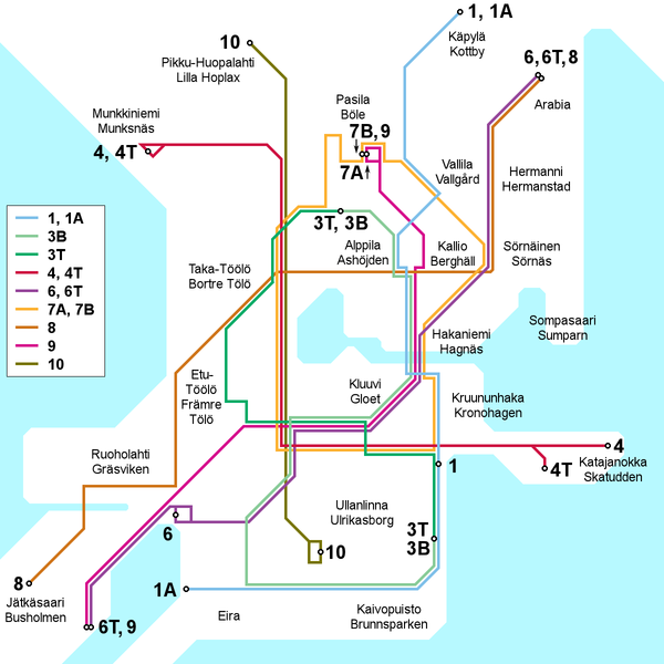
English: Map of the Helsinki tram network, current as of 30 March 2009. Place names in Finnish and Swedish. This file is being kept up to date (or at least attempted to) by Kjet.
Suomi: Kartta Helsingin raitiotieverkosta 30. maaliskuuta 2009 tilanteen mukaan. Paikannimet suomeksi ja ruotsiksi. Kjet pitää (tai ainakin yrittää pitää) tämän tiedoston ajantasalla.
Svenska: Kartan över Helsingfors spårvägslinjer, aktuell av 30 mars 2009. Namn på finska och svenska. Denna filet är uppdaterad av Kjet. |
| Date | |
| Source | Own work |
| Author | Kjet |

|
This transport map image could be re-created using vector graphics as an SVG file. This has several advantages; see Commons:Media for cleanup for more information. If an SVG form of this image is available, please upload it and afterwards replace this template with
{{vector version available|new image name}}.
It is recommended to name the SVG file “Helsinki tram map.svg”—then the template Vector version available (or Vva) does not need the new image name parameter. |
Licensing
I, the copyright holder of this work, hereby publish it under the following license:
This file is licensed under the Creative Commons Attribution 3.0 Unported license.
- You are free:
- to share – to copy, distribute and transmit the work
- to remix – to adapt the work
- Under the following conditions:
- attribution – You must give appropriate credit, provide a link to the license, and indicate if changes were made. You may do so in any reasonable manner, but not in any way that suggests the licensor endorses you or your use.
File history
Click on a date/time to view the file as it appeared at that time.
| Date/Time | Thumbnail | Dimensions | User | Comment | |
|---|---|---|---|---|---|
| current | 14:40, 3 February 2013 | | 1,200 × 1,200 (98 KB) | Kjet | Updated with the autumn 2012 extension of line 9 and the new line 6T opened in January 2013. |
| 21:00, 11 July 2012 |  | 1,200 × 1,200 (96 KB) | Kjet | Updated with the changed route of line 8 from 2012-01-01. Apologies for the delay. | |
| 09:22, 13 January 2010 |  | 1,200 × 1,200 (96 KB) | Kjet | Corrected the accidentally reversed directions for lines 7A and 7B. | |
| 19:51, 29 March 2009 |  | 1,200 × 1,200 (96 KB) | Kjet | {{Information |Description={{en|1=Map of the Helsinki tram network, current as of 30 March 2009. Place names in Finnish and Swedish. This file is being kept up to date (or at least attempted to) by Kjet.}} {{fi|1=Kartta Helsingin raitiotieve |
File usage
There are no pages that use this file.
Global file usage
The following other wikis use this file:
- Usage on en.wikipedia.org
- Usage on es.wikivoyage.org
- Usage on he.wikivoyage.org
- Usage on it.wikipedia.org
- Usage on ja.wikipedia.org
- Usage on tr.wikipedia.org