File:Jastrabia veža from dolina Zeleného plesa.jpg

Size of this preview: 800 × 379 pixels. Other resolutions: 320 × 152 pixels | 640 × 303 pixels | 1,024 × 485 pixels | 1,280 × 606 pixels | 2,560 × 1,213 pixels | 6,720 × 3,183 pixels.
Original file (6,720 × 3,183 pixels, file size: 6.25 MB, MIME type: image/jpeg)
This is a file from the Wikimedia Commons and may be used by other projects. Information from its description page there is shown below.
Commons is a freely licensed media file repository. |
|
Summary
| Description |
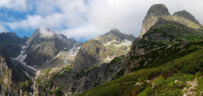
English: Jastrabia veža (on the right) as seen from dolina Zeleného plesa valley, High Tatras, Slovakia. Shrubs are Pinus mugo.
Polski: Jastrzębia Turnia (Jastrabia veža, po prawej) widziana ze szlaku na Jagnięcy Szczyt (Jahňaci štít) z Doliny Zielonego Stawu (dolina Zeleného plesa) w Tatrach słowackich. Widoczne na zdjęciu dolinki (od prawej) Jastrzębia, Dzika i Miedziana Kotlina wchodzą w skład Doliny Zielonego Stawu. |
| Date | |
| Source | Own work |
| Author | Marcin Białek |
| Camera location | | View this and other nearby images on: OpenStreetMap |
|---|
| This is a retouched picture, which means that it has been digitally altered from its original version. Modifications: panorama made of 6 images merged with autostich; levels corrected.
|
Licensing
I, the copyright holder of this work, hereby publish it under the following licenses:

|
Permission is granted to copy, distribute and/or modify this document under the terms of the GNU Free Documentation License, Version 1.2 or any later version published by the Free Software Foundation; with no Invariant Sections, no Front-Cover Texts, and no Back-Cover Texts. A copy of the license is included in the section entitled GNU Free Documentation License. |
This file is licensed under the Creative Commons Attribution-Share Alike 4.0 International, 3.0 Unported, 2.5 Generic, 2.0 Generic and 1.0 Generic license.
- You are free:
- to share – to copy, distribute and transmit the work
- to remix – to adapt the work
- Under the following conditions:
- attribution – You must give appropriate credit, provide a link to the license, and indicate if changes were made. You may do so in any reasonable manner, but not in any way that suggests the licensor endorses you or your use.
- share alike – If you remix, transform, or build upon the material, you must distribute your contributions under the same or compatible license as the original.
You may select the license of your choice.
| Annotations | This image is annotated: View the annotations at Commons |
File history
Click on a date/time to view the file as it appeared at that time.
| Date/Time | Thumbnail | Dimensions | User | Comment | |
|---|---|---|---|---|---|
| current | 20:09, 1 August 2008 | | 6,720 × 3,183 (6.25 MB) | Sfu | {{Information |Description={{en|1=Jastrabia veža (on the left) as seen from dolina Zeleného plesa valley, High Tatras, Slovakia.}} {{pl|1=Jastrzębia Turnia (Jastrabia veža) widziana ze szlaku na [[:pl:Jagnięcy Szczyt|Jagni� |
File usage
The following page uses this file:
Global file usage
The following other wikis use this file:
- Usage on ca.wikipedia.org
- Usage on ceb.wikipedia.org
- Usage on cs.wikipedia.org
- Usage on fr.wikipedia.org
- Usage on incubator.wikimedia.org
- Usage on lld.wikipedia.org
- Usage on pl.wikipedia.org
- Jastrzębia Turnia (Tatry)
- Dolina Zielona Kieżmarska
- Dolina Dzika
- Miedziana Kotlina
- Wikipedia:Ilustracje na Medal/geografia fizyczna
- Wikipedia:Propozycje do Ilustracji na Medal/Jastrabia veža from dolina Zeleného plesa.jpg
- Dyskusja pliku:Jastrabia veža from dolina Zeleného plesa.jpg
- Szablon:Ilustracja na medal/2010-10-17
- Szablon:Ilustracja na medal/2011-07-18
- Szablon:Ilustracja na medal/2012-08-26
- Szablon:Ilustracja na medal/2013-09-28
- Wikipedysta:The Polish/Nieużywane szablony/Ilustracja na medal/1-500
- Wikipedysta:The Polish/Nieużywane szablony/Ilustracja na medal/501-1000
- Wikipedysta:The Polish/Nieużywane szablony/Ilustracja na medal/1001-1500
- Usage on sk.wikipedia.org
- Usage on sl.wikipedia.org
- Usage on uk.wikivoyage.org
- Usage on ur.wikipedia.org
- Usage on www.wikidata.org