File:Karte vom Lausitzer Seenland.png
Size of this preview: 684 × 600 pixels. Other resolutions: 274 × 240 pixels | 547 × 480 pixels | 876 × 768 pixels | 1,168 × 1,024 pixels | 1,968 × 1,726 pixels.
Original file (1,968 × 1,726 pixels, file size: 1.33 MB, MIME type: image/png)
This is a file from the Wikimedia Commons and may be used by other projects. Information from its description page there is shown below.
Commons is a freely licensed media file repository. |
| Description |
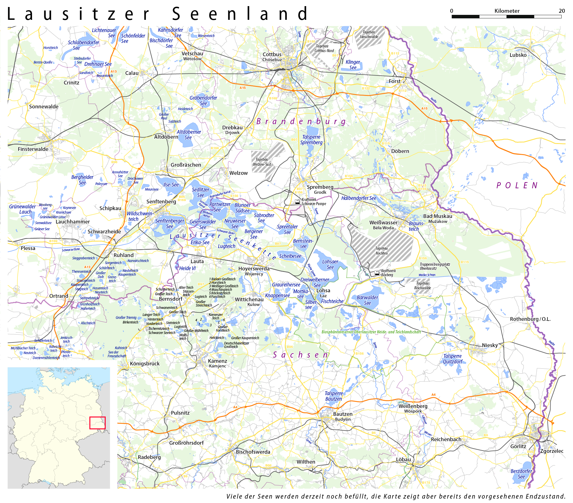
Deutsch: Karte vom Lausitzer Seenland |
| Date | see file history |
| Source |
own work, using
|
| Author | Maximilian Dörrbecker (Chumwa) |
| Permission (Reusing this file) |
All OpenStreetMap data and maps are Creative Commons "CC-BY-SA 2.0" licensed This file is licensed under the Creative Commons Attribution-Share Alike 2.0 Generic license.
|
File history
Click on a date/time to view the file as it appeared at that time.
| Date/Time | Thumbnail | Dimensions | User | Comment | |
|---|---|---|---|---|---|
| current | 14:00, 4 May 2016 | | 1,968 × 1,726 (1.33 MB) | Kopiersperre | optipng |
| 07:27, 1 May 2016 |  | 1,968 × 1,726 (1.99 MB) | Chumwa | Signaturfarben der Straßen geändert | |
| 13:34, 26 August 2014 |  | 1,967 × 1,725 (1.18 MB) | Kopiersperre | optipng | |
| 21:38, 13 August 2009 |  | 1,967 × 1,725 (1.86 MB) | Chumwa | Schlabendorfer See, Drehnaer See und Kahnsdorfer See nachgetragen | |
| 20:52, 30 July 2009 |  | 1,967 × 1,725 (1.86 MB) | Chumwa | Braunsteiche weg, dafür Braunsteich und Halbendorfer See beschriftet, Kraftwerk Boxberg, Kraftwerk Schwarze Pumpe, Biosphärenreservat Oberlausitzer Heide- und Teichlandschaft und Truppenübungsplatz Oberlausitz eingefügt, Rothenburg O.L. in Rothenburg/ | |
| 14:00, 24 July 2009 |  | 1,967 × 1,725 (1.84 MB) | Chumwa | hatte die falsch Auflösung gewählt... | |
| 13:53, 24 July 2009 |  | 5,464 × 4,791 (4.1 MB) | Chumwa | zu Lohsa den sorbischen Namen hinzugefügt, Braunsteiche beschriftet, Hinweis hinzugefügt, dass die Seen noch befüllt werden | |
| 15:33, 23 July 2009 |  | 1,966 × 1,695 (1.83 MB) | Chumwa | Seennamen angepasst | |
| 20:22, 22 July 2009 |  | 1,966 × 1,695 (1.83 MB) | Chumwa | Heide VI und Erika-See nachdigitalisiert, Tagebau Klettwitz herausgenommen, Schwarzheide hinzugefügt, Kanäle nachgetragen | |
| 05:43, 22 July 2009 |  | 1,966 × 1,695 (1.82 MB) | Chumwa | Flüsse mit aufgenommen, Tagebau Nochten erweitert, kleinere Anpassungn |
File usage
The following page uses this file:
Global file usage
The following other wikis use this file:
- Usage on cs.wikipedia.org
- Usage on de.wikipedia.org
- Usage on dsb.wikipedia.org
- Usage on en.wikipedia.org
- Usage on hsb.wikipedia.org
- Usage on ru.wikipedia.org