File:Louisbourg Lighthouse.jpg
Original file (4,288 × 2,848 pixels, file size: 11.81 MB, MIME type: image/jpeg)
This is a file from the Wikimedia Commons and may be used by other projects. Information from its description page there is shown below.
Commons is a freely licensed media file repository. |
Summary
| Description |
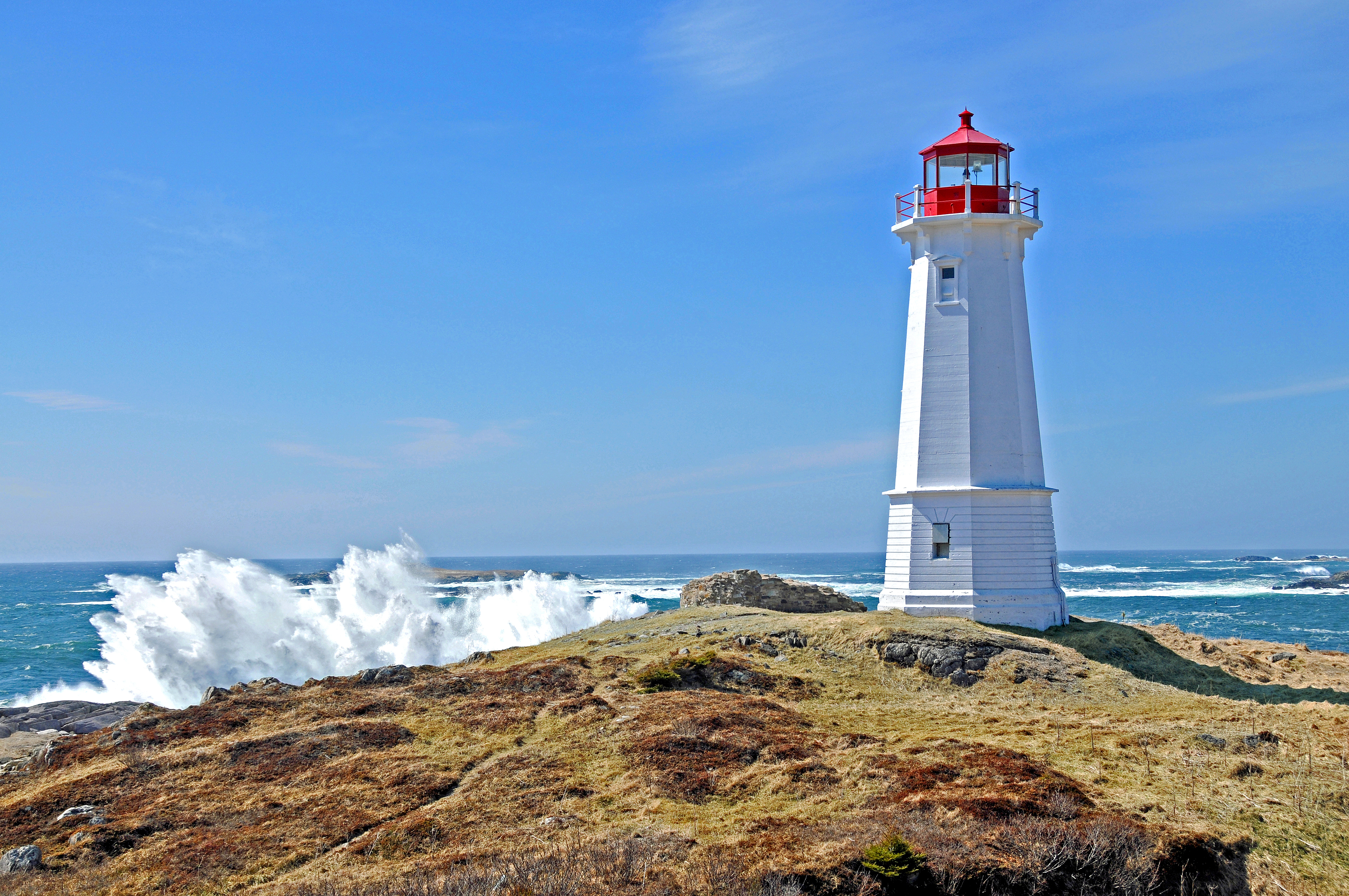
Louisbourg Lighthouse, 2008. This is the third light and was completed in 1923, a year after the second light burned. It is a white concrete octagonal tower, 55 feet high. Several modifications have been made to the characteristic of the light over time. Louisbourg, Nova Scotia, Canada The lighthouse constructed by the French at Louisbourg was the first established in Canada, and the second on the North American continent. (The first North American light was lit on September 14, 1716 on Little Brewster Island in Boston Harbour.) Louisbourg, built near the northeast corner of Cape Breton Island, was the base from which the French planned to hold New France against the English. The Fortress was dependant upon ships from France to supply most of its needs. Safe entrance to the harbour at the end of the long voyage became a concern. The initial plan to build a tower and light was made in late 1727, though the formal decision to build was not made until spring of 1729, after one of the King's ships, Le Profond nearly met its end in the harbour which was marked only by a navigational cross, and periodically by a bonfire. |
This photo is of a cultural heritage site in Canada, number 9654
|
|
| Date | |
| Source |
DSC_4266 - Louisbourg Lighthouse
|
| Author | Dennis Jarvis from Halifax, Canada |
| Camera location | | View this and other nearby images on: OpenStreetMap |
|---|
Licensing
- You are free:
- to share – to copy, distribute and transmit the work
- to remix – to adapt the work
- Under the following conditions:
- attribution – You must give appropriate credit, provide a link to the license, and indicate if changes were made. You may do so in any reasonable manner, but not in any way that suggests the licensor endorses you or your use.
- share alike – If you remix, transform, or build upon the material, you must distribute your contributions under the same or compatible license as the original.
| This image, originally posted to Flickr, was reviewed on July 29, 2011 by the administrator or reviewer File Upload Bot (Magnus Manske), who confirmed that it was available on Flickr under the stated license on that date. |
File history
Click on a date/time to view the file as it appeared at that time.
| Date/Time | Thumbnail | Dimensions | User | Comment | |
|---|---|---|---|---|---|
| current | 23:00, 29 July 2011 | | 4,288 × 2,848 (11.81 MB) | File Upload Bot (Magnus Manske) | {{Information |Description=This is the third light and was completed in 1923, a year after the second light burned. It is a white concrete octagonal tower, 55 feet high. Several modifications have been made to the characteristic of the light over time. Lo |
File usage
The following page uses this file:
Global file usage
The following other wikis use this file:
- Usage on de.wikipedia.org
- Usage on en.wikipedia.org
- Usage on fr.wikipedia.org
- Usage on it.wikipedia.org
- Usage on ja.wikipedia.org
- Usage on ru.wikipedia.org
- Usage on www.wikidata.org