File:Map of the tunnels of the Faroe Islands.png

Size of this preview: 568 × 600 pixels. Other resolutions: 227 × 240 pixels | 455 × 480 pixels | 728 × 768 pixels | 970 × 1,024 pixels | 1,940 × 2,048 pixels | 3,027 × 3,195 pixels.
Original file (3,027 × 3,195 pixels, file size: 3.21 MB, MIME type: image/png)
This is a file from the Wikimedia Commons and may be used by other projects. Information from its description page there is shown below.
Commons is a freely licensed media file repository. |

|
This map image could be re-created using vector graphics as an SVG file. This has several advantages; see Commons:Media for cleanup for more information. If an SVG form of this image is available, please upload it and afterwards replace this template with
{{vector version available|new image name}}.
It is recommended to name the SVG file “Map of the tunnels of the Faroe Islands.svg”—then the template Vector version available (or Vva) does not need the new image name parameter. |
| Description |
Català: Mapa dels túnels de les Illes Fèroe
Deutsch: Karte der Tunnel auf den Färöern
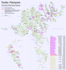
English: Map of the tunnels of the Faroe Islands |
| Date | see file history |
| Source | Own work, using Openstreetmap data for the background |
| Author | Maximilian Dörrbecker (Chumwa) |
| Permission (Reusing this file) |
All OpenStreetMap data and maps are Creative Commons "CC-BY-SA 2.0" licensed This file is licensed under the Creative Commons Attribution-Share Alike 2.0 Generic license.
|
File history
Click on a date/time to view the file as it appeared at that time.
| Date/Time | Thumbnail | Dimensions | User | Comment | |
|---|---|---|---|---|---|
| current | 18:19, 19 December 2020 | | 3,027 × 3,195 (3.21 MB) | Karl432 | Eysturoyatunnilin opened on 2020-12-19 |
| 07:51, 23 December 2016 |  | 3,027 × 3,195 (3.21 MB) | Chumwa | ||
| 16:31, 21 December 2016 |  | 3,027 × 3,195 (3.02 MB) | Chumwa | ||
| 23:09, 20 December 2016 |  | 3,011 × 3,195 (946 KB) | Chumwa | ||
| 22:34, 20 December 2016 |  | 3,011 × 3,195 (942 KB) | Chumwa | ||
| 21:15, 19 December 2016 |  | 3,011 × 3,195 (929 KB) | Chumwa | ||
| 06:36, 19 December 2016 |  | 3,011 × 3,195 (904 KB) | Chumwa | ||
| 23:05, 18 December 2016 |  | 3,011 × 3,195 (886 KB) | Chumwa | ||
| 18:53, 18 December 2016 |  | 3,011 × 3,195 (902 KB) | Chumwa | {{Information |Description= {{de|Karte der Tunnel auf den Färöern}} {{en|Map of the tunnels of the Faroe Islands}} |Author=Maximilian Dörrbecker (Chumwa) |Source={{own}}, using Openstreetmap data for the back... |
File usage
The following page uses this file:
Global file usage
The following other wikis use this file:
- Usage on ca.wikipedia.org
- Usage on cs.wikipedia.org
- Usage on da.wikipedia.org
- Usage on de.wikipedia.org
- Usage on en.wikipedia.org
- Usage on fo.wikipedia.org
- Usage on fr.wikipedia.org
- Usage on hu.wikipedia.org
- Usage on is.wikipedia.org
- Usage on it.wikipedia.org
- Usage on nl.wikipedia.org
- Usage on no.wikipedia.org
- Usage on sv.wikipedia.org