File:Miami districts map proposed.png
No higher resolution available.
Miami_districts_map_proposed.png (637 × 568 pixels, file size: 447 KB, MIME type: image/png)
This is a file from the Wikimedia Commons and may be used by other projects. Information from its description page there is shown below.
Commons is a freely licensed media file repository. |
Summary
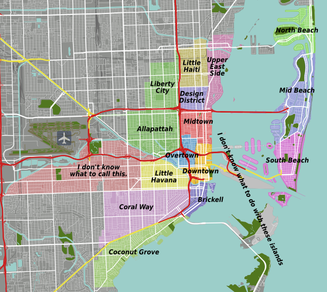
| Description |
English: Miami travel districts map. Map of proposed districts on 9 Sep 2012. |
| Date | |
| Source | Miami Districts map.svg, OpenStreetMap [1] |
| Author | Peter Fitzgerald, OpenStreetMap [2] |
Licensing
This file is licensed under the Creative Commons Attribution-Share Alike 2.0 Generic license.
- You are free:
- to share – to copy, distribute and transmit the work
- to remix – to adapt the work
- Under the following conditions:
- attribution – You must give appropriate credit, provide a link to the license, and indicate if changes were made. You may do so in any reasonable manner, but not in any way that suggests the licensor endorses you or your use.
- share alike – If you remix, transform, or build upon the material, you must distribute your contributions under the same or compatible license as the original.
Original upload log
| This file was imported from Wikivoyage WTS. |
The original description page was here. All following user names refer to wts.wikivoyage-old.
- 2012-09-09 18:39 Peterfitzgerald archive copy at the Wayback Machine 637×568 (457800 bytes) {{Imagecredit|credit=Peter Fitzgerald, OpenStreetMap [http://openstreetmap.org]|captureDate=9 September 2012|location=Miami|source=[[:File:Miami Districts map.svg]], OpenStreetMap [http://openstreetmap.org]|caption=Districts map|description=Map of prop...
File history
Click on a date/time to view the file as it appeared at that time.
| Date/Time | Thumbnail | Dimensions | User | Comment | |
|---|---|---|---|---|---|
| current | 01:21, 18 November 2012 | | 637 × 568 (447 KB) | MGA73bot2 | {{BotMoveToCommons|wts.oldwikivoyage|year={{subst:CURRENTYEAR}}|month={{subst:CURRENTMONTHNAME}}|day={{subst:CURRENTDAY}}}} == {{int:filedesc}} == {{Information |description=Districts map. Map of proposed districts on 9 Sep 2012, Miami * Map of: Miami... |
File usage
The following page uses this file: