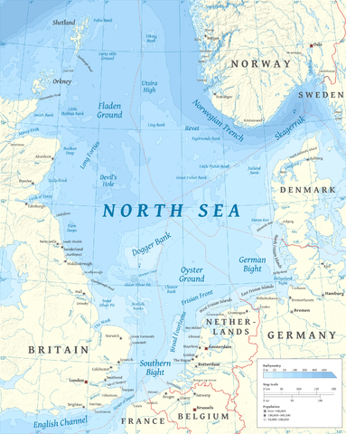
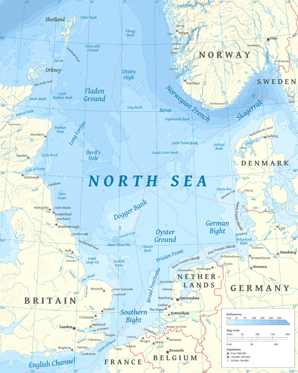
File:North Sea map-en.png

Size of this preview: 479 × 600 pixels. Other resolutions: 192 × 240 pixels | 383 × 480 pixels | 613 × 768 pixels | 817 × 1,024 pixels | 2,475 × 3,100 pixels.
Original file (2,475 × 3,100 pixels, file size: 3.8 MB, MIME type: image/png)
This is a file from the Wikimedia Commons and may be used by other projects. Information from its description page there is shown below.
Commons is a freely licensed media file repository. |
P
Summary
| Description | |
| Date | |
| Source |
Own work using en:GRASS GIS, en:Inkscape and en:GIMP. Data sources:
Map Projection: Universal Transverse Mercator Typeface: Gentium Book Basic from SIL International |
| Author | Halava |
| Other versions |
  |
Licensing
I, the copyright holder of this work, hereby publish it under the following licenses:
This file is licensed under the Creative Commons Attribution-Share Alike 3.0 Unported license.
- You are free:
- to share – to copy, distribute and transmit the work
- to remix – to adapt the work
- Under the following conditions:
- attribution – You must give appropriate credit, provide a link to the license, and indicate if changes were made. You may do so in any reasonable manner, but not in any way that suggests the licensor endorses you or your use.
- share alike – If you remix, transform, or build upon the material, you must distribute your contributions under the same or compatible license as the original.

|
Permission is granted to copy, distribute and/or modify this document under the terms of the GNU Free Documentation License, Version 1.2 or any later version published by the Free Software Foundation; with no Invariant Sections, no Front-Cover Texts, and no Back-Cover Texts. A copy of the license is included in the section entitled GNU Free Documentation License. |
You may select the license of your choice.
| Annotations | This image is annotated: View the annotations at Commons |
File history
Click on a date/time to view the file as it appeared at that time.
| Date/Time | Thumbnail | Dimensions | User | Comment | |
|---|---|---|---|---|---|
| current | 17:23, 5 March 2015 | | 2,475 × 3,100 (3.8 MB) | Tandru7 | {{Information |Description=Map of the North Sea |Source=Wiki Commons |Date=3/5/15 |Author= |Permission= |other_versions= }} |
| 14:48, 15 October 2010 |  | 2,475 × 3,100 (3.8 MB) | Halava | New place names | |
| 17:34, 12 October 2010 |  | 2,475 × 3,100 (3.79 MB) | Halava | Some corrections; several new place names | |
| 11:02, 12 October 2010 |  | 2,475 × 3,100 (3.78 MB) | Halava | Minor corrections; improved legibility; Horns Rev | |
| 08:09, 10 October 2010 |  | 2,475 × 3,100 (3.72 MB) | Halava | Exclusive economic zones; Heligoland | |
| 09:26, 9 October 2010 |  | 2,475 × 3,100 (3.64 MB) | Halava | Lindisfarne; Norfolk Banks instead of Wells Bank | |
| 20:27, 8 October 2010 |  | 2,475 × 3,100 (3.63 MB) | Halava | Outlined Dogger Bank, fixed a typo | |
| 17:04, 8 October 2010 |  | 2,475 × 3,100 (3.61 MB) | Halava | Several improvements | |
| 10:52, 6 October 2010 |  | 2,475 × 3,100 (3.37 MB) | Halava | Fixed two typos, switched color model to RGB | |
| 10:09, 6 October 2010 |  | 2,475 × 3,100 (2.57 MB) | Halava | {{Information |Description={{en|1=Map of the North Sea.}} |Source={{own}} using GRASS GIS, Inkscape and GIMP. Data sources: * Elevation and bathymetry data from NGDC ETOPO1 * Coastlines, rivers and borders from NGDC World Data Bank II * Cities from OpenS |
File usage
The following page uses this file:
Global file usage
The following other wikis use this file:
- Usage on af.wikipedia.org
- Usage on ar.wikipedia.org
- Usage on arz.wikipedia.org
- Usage on ast.wikipedia.org
- Usage on ba.wikipedia.org
- Usage on be-tarask.wikipedia.org
- Usage on bg.wikipedia.org
- Usage on br.wikipedia.org
- Usage on ca.wikipedia.org
- Usage on cs.wikipedia.org
- Usage on cy.wikipedia.org
- Usage on de.wikipedia.org
- Usage on de.wikivoyage.org
- Usage on el.wikipedia.org
- Usage on en.wikipedia.org
- North Sea
- Skagerrak
- SMS Lützow
- HMS King Edward VII
- HMS Marlborough (1912)
- HMS Emperor of India
- HMS Africa (1905)
- Horns Rev
- HMS Britannia (1904)
- Silverpit crater
- Broad Fourteens
- Dogger Bank
- Long Forties
- HMS Hibernia (1905)
- Fisher Bank
- Norwegian trench
- Silver Pit
- Wikipedia:Userboxes/Location
- Operation Wikinger
- HMS Commonwealth
- Northern Patrol
- Raid on Scarborough, Hartlepool and Whitby
- HMS Hindustan (1903)
- User:Buaidh
- Southern Bight
- History of the North Sea
- First Ostend Raid
- Bombardment of Yarmouth and Lowestoft
View more global usage of this file.