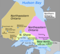
File:Northern Ontario Static Map.png

Size of this preview: 657 × 599 pixels. Other resolutions: 263 × 240 pixels | 526 × 480 pixels | 842 × 768 pixels | 1,123 × 1,024 pixels | 2,245 × 2,048 pixels | 5,000 × 4,561 pixels.
Original file (5,000 × 4,561 pixels, file size: 1.23 MB, MIME type: image/png)
File history
Click on a date/time to view the file as it appeared at that time.
| Date/Time | Thumbnail | Dimensions | User | Comment | |
|---|---|---|---|---|---|
| current | 22:13, 18 September 2021 |  | 5,000 × 4,561 (1.23 MB) | SelfieCity | title format |
| 16:24, 18 September 2021 |  | 5,000 × 4,561 (1.19 MB) | SelfieCity | color tweak | |
| 16:22, 18 September 2021 |  | 5,000 × 4,561 (1.19 MB) | SelfieCity | bodies of water label and color adjustment | |
| 16:01, 18 September 2021 |  | 5,000 × 4,561 (1.05 MB) | SelfieCity | tweak region boundary per voy:Talk:Northern Ontario | |
| 19:34, 15 September 2021 |  | 4,910 × 4,477 (1.04 MB) | SelfieCity | Cropped 2 % horizontally, 2 % vertically using CropTool with precise mode. | |
| 18:25, 15 September 2021 |  | 5,000 × 4,561 (1.06 MB) | SelfieCity | adjust text of St. Joseph Island | |
| 18:22, 15 September 2021 |  | 11,668 × 10,546 (2.91 MB) | SelfieCity | Cropped 6 % horizontally, 40 % vertically using CropTool with precise mode. | |
| 18:20, 15 September 2021 |  | 12,417 × 17,561 (3.29 MB) | SelfieCity | fix stretched image preview issue | |
| 18:12, 15 September 2021 |  | 4,676 × 4,266 (1,009 KB) | SelfieCity | add cities, parks, etc. | |
| 16:46, 15 September 2021 |  | 4,674 × 5,163 (835 KB) | SelfieCity | rm eastern part of Ontario |
File usage
The following 2 pages use this file: