File:Oil City Armory.jpg

Size of this preview: 800 × 450 pixels. Other resolutions: 320 × 180 pixels | 640 × 360 pixels | 1,024 × 576 pixels | 1,280 × 720 pixels | 2,816 × 1,584 pixels.
Original file (2,816 × 1,584 pixels, file size: 1.16 MB, MIME type: image/jpeg)
This is a file from the Wikimedia Commons and may be used by other projects. Information from its description page there is shown below.
Commons is a freely licensed media file repository. |
|
This is an image of a place or building that is listed on the National Register of Historic Places in the United States of America. Its reference number is 91000517. |
| Camera location | | View this and other nearby images on: OpenStreetMap |
|---|
| Description |
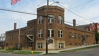
English: Northern and western sides of the Oil City Armory, located on the southeastern corner of the junction of Second and State Streets in Oil City, Pennsylvania, United States. Built in 1914, it is listed on the National Register of Historic Places, and it is part of a Register-listed historic district, the Oil City South Side Historic District. |
||
| Date | Taken on 22 June 2013 | ||
| Source | Own work | ||
| Author | Nyttend | ||
| Permission (Reusing this file) |
|
File history
Click on a date/time to view the file as it appeared at that time.
| Date/Time | Thumbnail | Dimensions | User | Comment | |
|---|---|---|---|---|---|
| current | 21:59, 1 July 2013 | | 2,816 × 1,584 (1.16 MB) | Nyttend | {{NRHP|91000517}} {{Location|41|25|38|N|79|42|32|W}} {{Information |Description={{en|Northern and western sides of the {{w|Oil City Armory}}, located on the southeastern corner of the junction of Second and State Streets in {{w|Oil City, Pennsylvania|O... |
File usage
The following page uses this file:
Global file usage
The following other wikis use this file:
- Usage on en.wikipedia.org
- Usage on www.wikidata.org