File:Pier Blankenberge R02.jpg

Size of this preview: 490 × 600 pixels. Other resolutions: 196 × 240 pixels | 392 × 480 pixels | 627 × 768 pixels | 837 × 1,024 pixels | 1,876 × 2,296 pixels.
Original file (1,876 × 2,296 pixels, file size: 2.35 MB, MIME type: image/jpeg)
This is a file from the Wikimedia Commons and may be used by other projects. Information from its description page there is shown below.
Commons is a freely licensed media file repository. |
Summary
| Description |
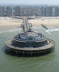
English: Blankenberge (Belgium): the Pier
Français : Blankenberge (Belgique): le Pier
Nederlands: Blankenberge (België): de Pier
Deutsch: Blankenberge (Belgien): der Pier
|
||
| Date | 13 June 2007 (according to Exif data) | ||
| Source | Own work | ||
| Author | Marc Ryckaert (MJJR) |
| Camera location | | View this and other nearby images on: OpenStreetMap |
|---|

|
This image was uploaded as part of Wiki Loves Monuments 2011.
|
 |
Licensing
I, the copyright holder of this work, hereby publish it under the following license:
This file is licensed under the Creative Commons Attribution-Share Alike 3.0 Unported license.
- You are free:
- to share – to copy, distribute and transmit the work
- to remix – to adapt the work
- Under the following conditions:
- attribution – You must give appropriate credit, provide a link to the license, and indicate if changes were made. You may do so in any reasonable manner, but not in any way that suggests the licensor endorses you or your use.
- share alike – If you remix, transform, or build upon the material, you must distribute your contributions under the same or compatible license as the original.
This image has been assessed using the Quality image guidelines and is considered a Quality image.
|
File history
Click on a date/time to view the file as it appeared at that time.
| Date/Time | Thumbnail | Dimensions | User | Comment | |
|---|---|---|---|---|---|
| current | 21:37, 20 September 2011 | | 1,876 × 2,296 (2.35 MB) | MJJR | {{Information |Description = {{en|1=Blankenberge (Belgium): the Pier}} {{fr|1=Blankenberge (Belgique): le Pier}} {{nl|1=Blankenberge (België): de Pier}} {{de|1=Blankenberge (Belgien): der Pier}} {{Onroerend_erfgoed|1=45057}} |Source = {{own}} |Author = [ |
File usage
The following page uses this file:
Global file usage
The following other wikis use this file:
- Usage on cs.wikipedia.org
- Usage on en.wikipedia.org
- Usage on eo.wikipedia.org
- Usage on nds-nl.wikipedia.org
- Usage on nl.wikipedia.org
- Usage on no.wikipedia.org
- Usage on uk.wikipedia.org
- Usage on vls.wikipedia.org
- Usage on www.wikidata.org