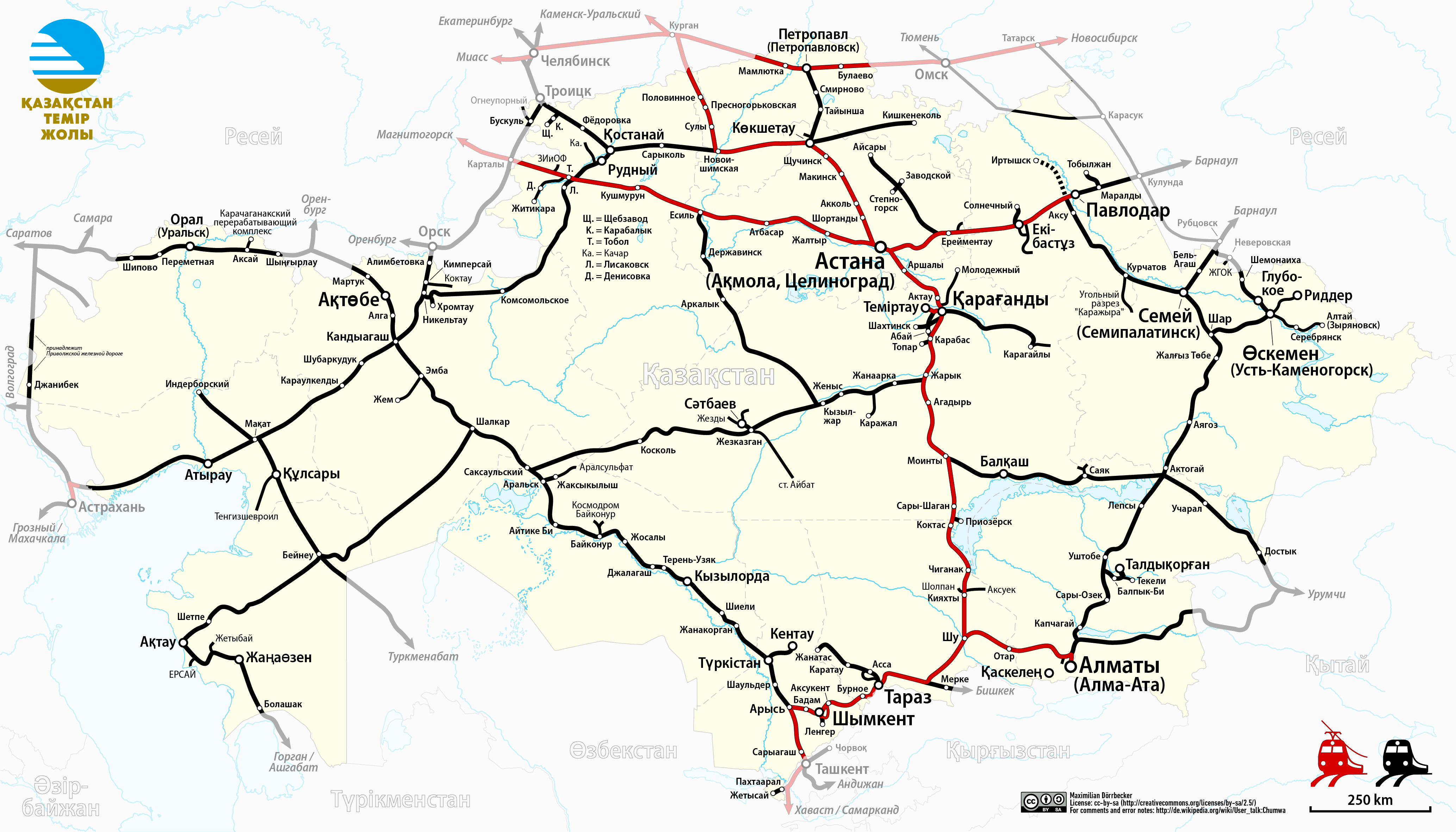
File:Railway Map of Kazakhstan (kk).png
Size of this preview: 800 × 457 pixels. Other resolutions: 320 × 183 pixels | 640 × 366 pixels | 1,024 × 585 pixels | 1,280 × 731 pixels | 2,560 × 1,463 pixels | 4,134 × 2,362 pixels.
Original file (4,134 × 2,362 pixels, file size: 1.49 MB, MIME type: image/png)
This is a file from the Wikimedia Commons and may be used by other projects. Information from its description page there is shown below.
Commons is a freely licensed media file repository. |
.png)
| Description |
|
| Date | see file history |
| Source |
Own work, using
|
| Author | Maximilian Dörrbecker (Chumwa) |
| Permission (Reusing this file) |
I, the copyright holder of this work, hereby publish it under the following license: This file is licensed under the Creative Commons Attribution-Share Alike 2.5 Generic license.
Sie dürfen das Bild zu den folgenden Bedingungen nutzen:
|
File history
Click on a date/time to view the file as it appeared at that time.
| Date/Time | Thumbnail | Dimensions | User | Comment | |
|---|---|---|---|---|---|
| current | 21:47, 25 March 2019 | | 4,134 × 2,362 (1.49 MB) | Chumwa | update |
| 18:39, 25 March 2019 |  | 4,134 × 2,362 (1.49 MB) | Chumwa | corr | |
| 21:59, 19 March 2019 |  | 4,134 × 2,362 (1.49 MB) | Chumwa | Zyryanovsk now is Altai | |
| 22:45, 27 February 2019 |  | 4,134 × 2,362 (1.49 MB) | Chumwa | The western line (two segments near Dzhanibek) belongs to the Volga railway | |
| 06:16, 15 August 2017 |  | 4,134 × 2,362 (1.48 MB) | Chumwa | ||
| 04:28, 14 August 2017 |  | 4,134 × 2,362 (1.5 MB) | Chumwa | ||
| 20:05, 13 August 2017 |  | 4,134 × 2,362 (1.49 MB) | Chumwa | ||
| 19:38, 13 August 2017 |  | 4,134 × 2,362 (1.49 MB) | Chumwa | {{Information |Description= *{{de|Eisenbahnkarte von Kasachstan}} *{{en|Railway map of Kazakhstan}} |Source={{Own}}, using * this file by {{U|NordNordWest}} as background * [[:File:Kazakhstan Temir Zholy Logo.svg|L... |
File usage
The following page uses this file:
Global file usage
The following other wikis use this file:
- Usage on ar.wikipedia.org
- Usage on az.wikipedia.org
- Usage on ba.wikipedia.org
- Usage on be.wikipedia.org
- Usage on de.wikipedia.org
- Usage on de.wikivoyage.org
- Usage on en.wikipedia.org
- Usage on eo.wikipedia.org
- Usage on es.wikipedia.org
- Usage on et.wikipedia.org
- Usage on fr.wikipedia.org
- Usage on fr.wikivoyage.org
- Usage on he.wikipedia.org
- Usage on hu.wikipedia.org
- Usage on it.wikipedia.org
- Usage on it.wikivoyage.org
- Usage on ja.wikipedia.org
- Usage on kk.wikipedia.org
- Usage on ko.wikipedia.org
- Usage on mk.wikipedia.org
- Usage on no.wikipedia.org
- Usage on pl.wikipedia.org
- Usage on ro.wikipedia.org
- Usage on ru.wikipedia.org
- Usage on sr.wikipedia.org
- Usage on sv.wikipedia.org
- Usage on tr.wikipedia.org
- Usage on tt.wikipedia.org
- Usage on uk.wikipedia.org
- Usage on www.wikidata.org
- Usage on zh.wikipedia.org
.png)