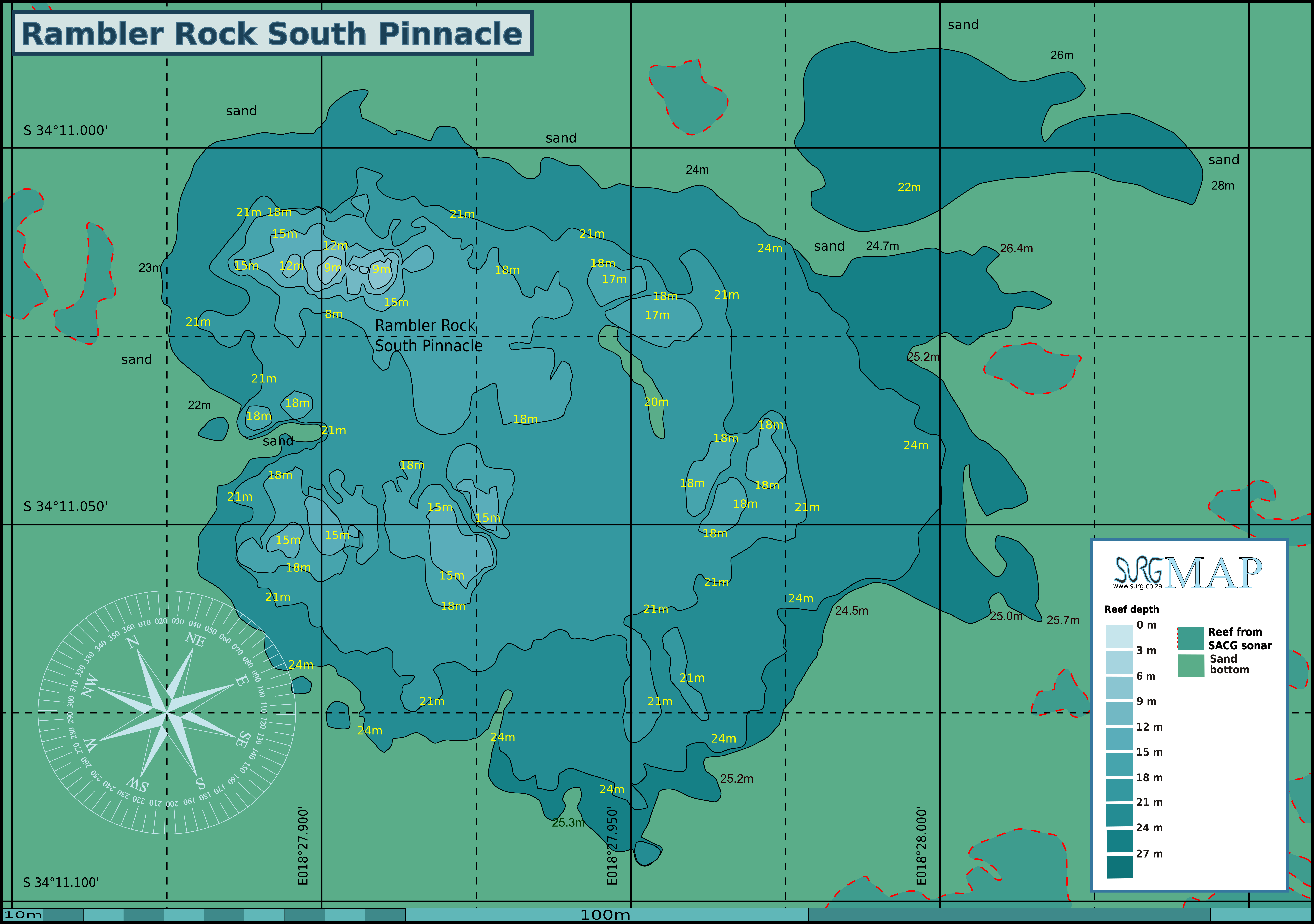
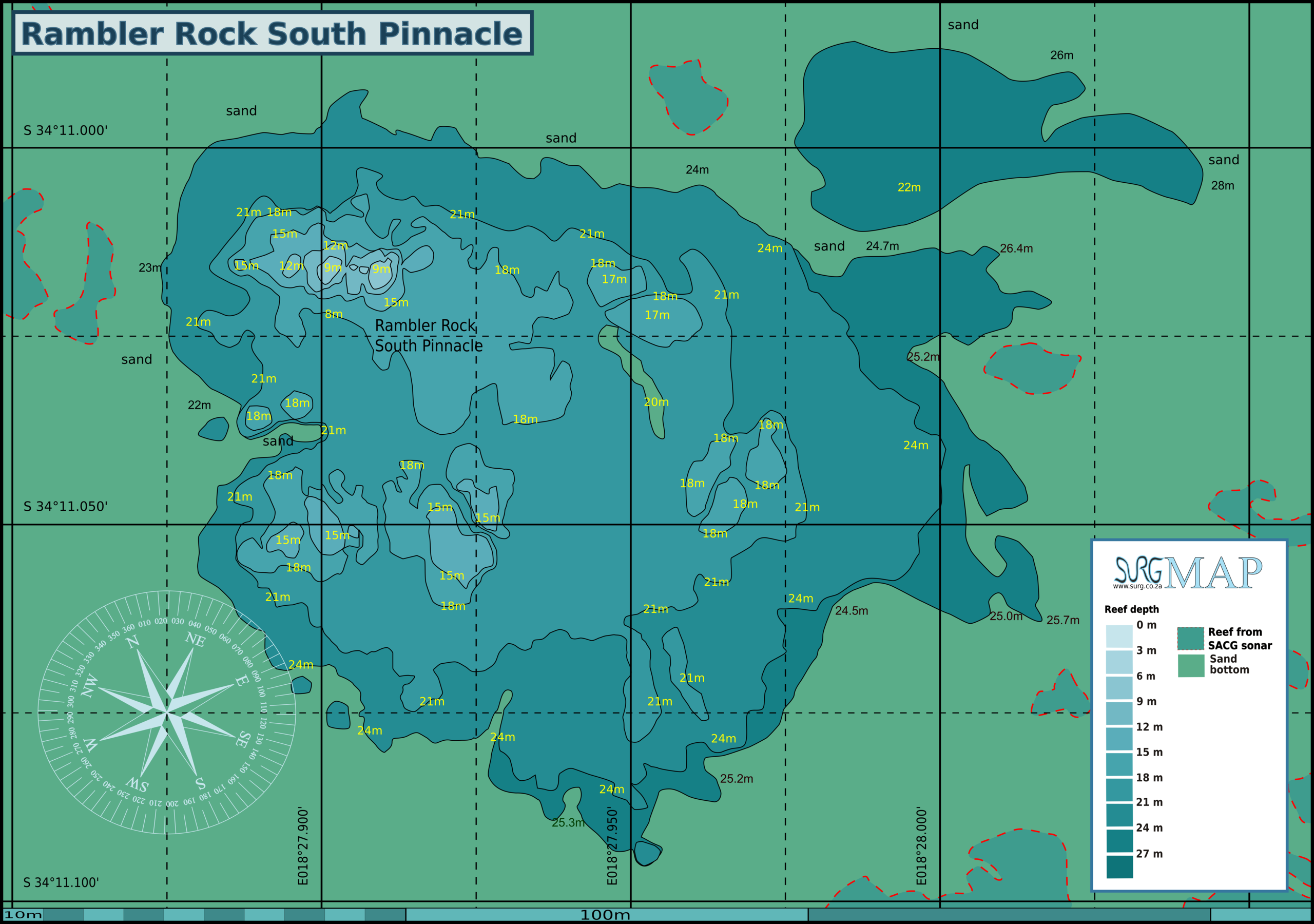
File:Rambler Rock South Pinnacle map.png
Size of this preview: 800 × 562 pixels. Other resolutions: 320 × 225 pixels | 640 × 450 pixels | 1,024 × 720 pixels | 1,280 × 900 pixels | 2,560 × 1,800 pixels | 7,800 × 5,484 pixels.
Original file (7,800 × 5,484 pixels, file size: 2.78 MB, MIME type: image/png)
This is a file from the Wikimedia Commons and may be used by other projects. Information from its description page there is shown below.
Commons is a freely licensed media file repository. |
Summary
| Description |
English: Map of the dive site at Rambler Rock South Pinnacle near Simon's Town in False Bay |
| Date | |
| Source | Own work |
| Author | Peter Southwood |
Licensing
I, the copyright holder of this work, hereby publish it under the following license:
This file is licensed under the Creative Commons Attribution-Share Alike 3.0 Unported license.
- You are free:
- to share – to copy, distribute and transmit the work
- to remix – to adapt the work
- Under the following conditions:
- attribution – You must give appropriate credit, provide a link to the license, and indicate if changes were made. You may do so in any reasonable manner, but not in any way that suggests the licensor endorses you or your use.
- share alike – If you remix, transform, or build upon the material, you must distribute your contributions under the same or compatible license as the original.
File history
Click on a date/time to view the file as it appeared at that time.
| Date/Time | Thumbnail | Dimensions | User | Comment | |
|---|---|---|---|---|---|
| current | 12:15, 21 June 2020 | | 7,800 × 5,484 (2.78 MB) | Pbsouthwood | completed perimeter |
| 12:39, 17 September 2018 |  | 7,800 × 5,484 (2.98 MB) | Pbsouthwood | added perimeter at east side with spot depths | |
| 11:23, 8 April 2018 |  | 7,963 × 5,878 (3 MB) | Pbsouthwood | 27m contour/perimeter added | |
| 16:16, 21 August 2017 |  | 7,302 × 5,583 (2.89 MB) | Pbsouthwood | updated with more 24m contour | |
| 21:28, 16 June 2014 |  | 2,999 × 2,293 (1,022 KB) | Pbsouthwood | complete 21m contour, add partial 24m contour and a few 15m contours | |
| 14:49, 11 June 2014 |  | 2,999 × 2,293 (940 KB) | Pbsouthwood | Complete 18m contour and extend 21m contour | |
| 15:52, 3 March 2014 |  | 2,999 × 2,293 (887 KB) | Pbsouthwood | additional 15 and 18m contours and partial perimeter at NW of reef | |
| 02:27, 1 March 2014 |  | 3,000 × 2,294 (809 KB) | Pbsouthwood | User created page with UploadWizard |
File usage
There are no pages that use this file.
Global file usage
The following other wikis use this file:
- Usage on www.wikidata.org