File:Santorini Oia (cropped).jpg
Size of this preview: 800 × 114 pixels. Other resolution: 1,459 × 208 pixels.
Original file (1,459 × 208 pixels, file size: 106 KB, MIME type: image/jpeg)
This is a file from the Wikimedia Commons and may be used by other projects. Information from its description page there is shown below.
Commons is a freely licensed media file repository. |
Summary
| Description |
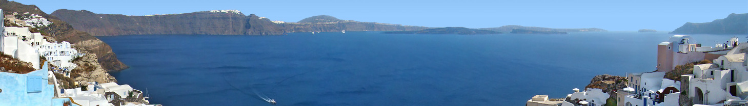
Ελληνικά: Οία, Θήρα, Ελλάδα.
English: Oia, Santorini, Greece. The circle of land collapsed following the ancient volcanic eruption is evident here. From left to beyond the centre at the horizon lies the southern part of the Santorini island, with the caldera plunging into the sea. On the right are the neighbouring islets of Nea Kameni, Palaia Kameni, Aspronisi and Thirasia, all part of the bigger island before the collapse.
Français : Oia, Santorin, Grèce. Le cercle de terre qui s'était affaissé après l'éruption volcanique de l'antiquité est évident ici. De gauche à passé le centre à l'horizon s'étend la partie sud de l'île de Santorin, avec la caldera plongeant dans la mer. Vers la droite sont visibles les îlots de Nea Kameni, Palaia Kameni, Aspronisi et Thirasia, toutes faisant partie de la plus grande île qui existait avant l'affaissement. |
| Date | |
| Source | Own work |
| Author | Tango7174 |
| Camera location | | View this and other nearby images on: OpenStreetMap |
|---|
Licensing
I, the copyright holder of this work, hereby publish it under the following licenses:

|
Permission is granted to copy, distribute and/or modify this document under the terms of the GNU Free Documentation License, Version 1.2 or any later version published by the Free Software Foundation; with no Invariant Sections, no Front-Cover Texts, and no Back-Cover Texts. A copy of the license is included in the section entitled GNU Free Documentation License. |
This file is licensed under the Creative Commons Attribution-Share Alike 4.0 International, 3.0 Unported, 2.5 Generic, 2.0 Generic and 1.0 Generic license.
- You are free:
- to share – to copy, distribute and transmit the work
- to remix – to adapt the work
- Under the following conditions:
- attribution – You must give appropriate credit, provide a link to the license, and indicate if changes were made. You may do so in any reasonable manner, but not in any way that suggests the licensor endorses you or your use.
- share alike – If you remix, transform, or build upon the material, you must distribute your contributions under the same or compatible license as the original.
You may select the license of your choice.
| Annotations | This image is annotated: View the annotations at Commons |


.jpg)
.jpg¶ms=036.461900_N_0025.378000_E_globe:Earth_type:camera__&language=en)
File history
Click on a date/time to view the file as it appeared at that time.
| Date/Time | Thumbnail | Dimensions | User | Comment | |
|---|---|---|---|---|---|
| current | 17:06, 8 June 2019 | 1,459 × 208 (106 KB) | ויקיג'אנקי | File:Santorini Oia2 tango7174.jpg cropped 12 % horizontally, 65 % vertically using CropTool with precise mode. |
File usage
The following page uses this file:
Global file usage
The following other wikis use this file:
- Usage on el.wikivoyage.org
- Usage on eo.wikipedia.org
- Usage on fr.wikivoyage.org
- Usage on he.wikivoyage.org
- Usage on it.wikivoyage.org
- Usage on nl.wikivoyage.org
- Usage on pl.wikivoyage.org
- Usage on ru.wikivoyage.org
- Usage on www.wikidata.org
.jpg)