File:Shanghai1907.jpg

Original file (1,104 × 742 pixels, file size: 151 KB, MIME type: image/jpeg)
This is a file from the Wikimedia Commons and may be used by other projects. Information from its description page there is shown below.
Commons is a freely licensed media file repository. |
Summary
| Description |
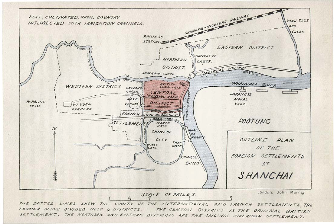
English: "Outline of the Plan of the Foreign Settlements at Shanghai", from Col. A. M. Murray's Imperial Outposts, from a Strategical and Commercial Aspect, with Special Reference to the Japanese Alliance. Published by John Murray (London), 1907. |
| Date | 27 March 2011 (original upload date) |
| Source |
http://www.lib.utexas.edu/maps/historical/shanghai_1907.jpg " I would like to use one of your historical maps http://www.lib.utexas.edu/maps/historical/shanghai_1907.jpg in the Wikivoyage (Wikivoyage.org) article on Shanghai. They require that anything uploaded be released under their Creative Commons 3.0 license. I have read your usage statement and it appears to me that this map is in the public domain so I can do that. However, I thought I'd better check. Their reply: " Thank you for your interest in the University of Texas Libraries' Map Collection. Unless marked otherwise, the maps scanned by the University Libraries are in the public domain. The map images are not copyrighted and no permission is needed to copy them. You may download them and use them as you wish. We do appreciate hearing from you about your use of these materials and we also appreciate you giving this site credit. Appropriate credit for public domain materials would be: "Courtesy of the University Libraries, The University of Texas at Austin."
|
| Author | John Murray |
Licensing
| This work has been released into the public domain by its author, www.lib.utexas.edu. This applies worldwide. In some countries this may not be legally possible; if so: www.lib.utexas.edu grants anyone the right to use this work for any purpose, without any conditions, unless such conditions are required by law.
|
Original upload log
| This file was imported from Wikivoyage WTS. |
- 2011-03-27 02:37 (WT-shared) Pashley 1104×742 (154734 bytes) Map is from the collection at U of Texas. I emailed them to ask about this: " I would like to use one of your historical maps http://www.li (Import from wikitravel.org/shared)
File history
Click on a date/time to view the file as it appeared at that time.
| Date/Time | Thumbnail | Dimensions | User | Comment | |
|---|---|---|---|---|---|
| current | 18:15, 3 May 2013 | | 1,104 × 742 (151 KB) | MGA73bot2 | {{BotMoveToCommons|wts.oldwikivoyage|year={{subst:CURRENTYEAR}}|month={{subst:CURRENTMONTHNAME}}|day={{subst:CURRENTDAY}}}} == {{int:filedesc}} == {{Information |description=Map is from the collection at U of Texas. I emailed them to ask about this: "... |
File usage
The following 3 pages use this file:
Global file usage
The following other wikis use this file:
- Usage on pl.wikivoyage.org