File:Somaliland regions map.png
Size of this preview: 800 × 513 pixels. Other resolutions: 320 × 205 pixels | 640 × 410 pixels | 1,024 × 657 pixels | 1,280 × 821 pixels | 1,600 × 1,026 pixels.
Original file (1,600 × 1,026 pixels, file size: 556 KB, MIME type: image/png)
This is a file from the Wikimedia Commons and may be used by other projects. Information from its description page there is shown below.
Commons is a freely licensed media file repository. |

|
This file was moved to Wikimedia Commons from wts.oldwikivoyage using a bot script. All source information is still present. It requires review. Additionally, there may be errors in any or all of the information fields; information on this file should not be considered reliable and the file should not be used until it has been reviewed and any needed corrections have been made. Once the review has been completed, this template should be removed. For details about this file, see below. Check now! |
Summary
| Description |
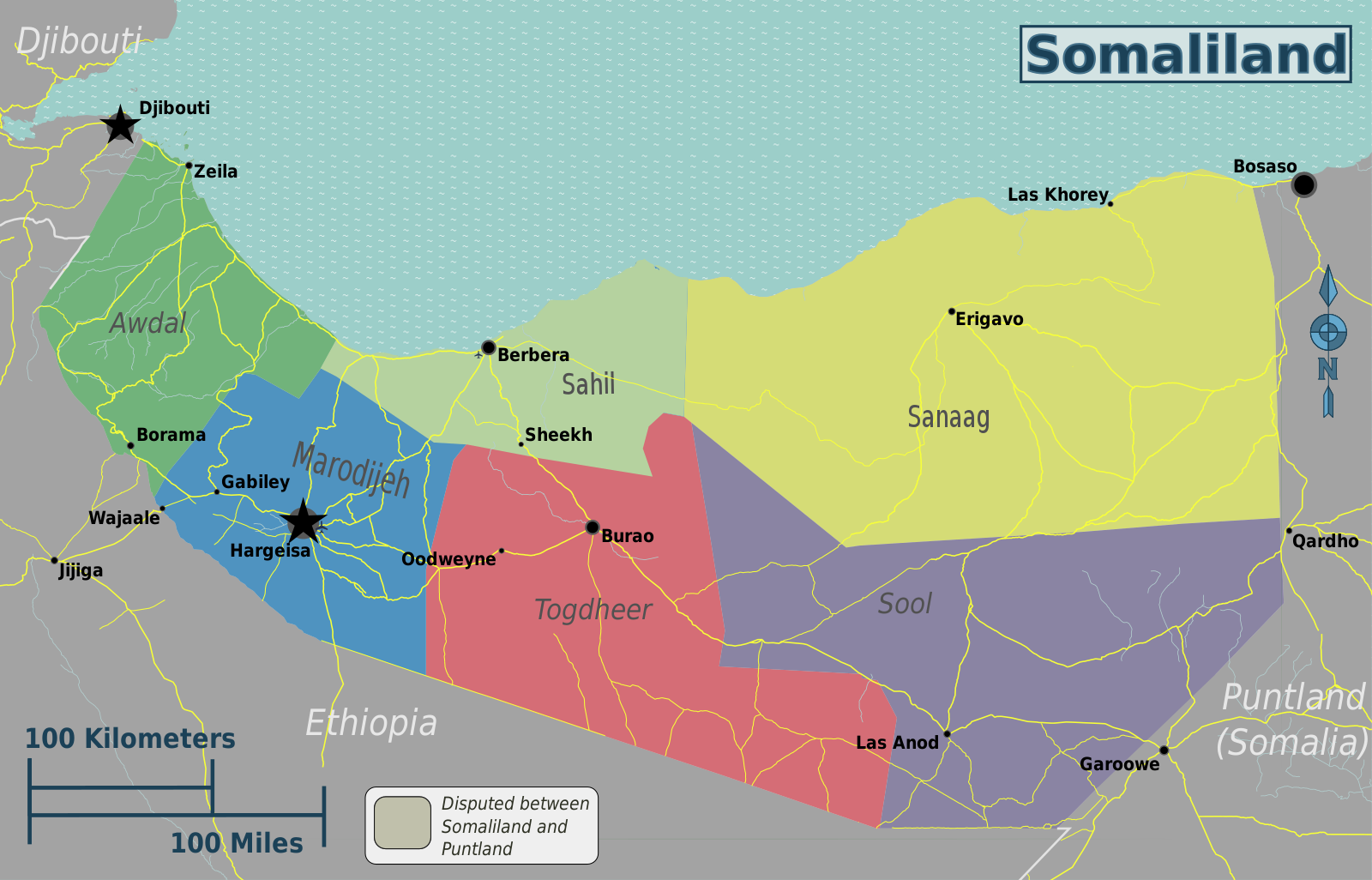
English: Somaliland regions map. English version, Somaliland
|
| Date | |
| Source | File:Somaliland regions map.svg |
| Author | Peter Fitzgerald, OpenStreetMap [1] |
Licensing
This file is licensed under the Creative Commons Attribution-Share Alike 2.0 Generic license.
- You are free:
- to share – to copy, distribute and transmit the work
- to remix – to adapt the work
- Under the following conditions:
- attribution – You must give appropriate credit, provide a link to the license, and indicate if changes were made. You may do so in any reasonable manner, but not in any way that suggests the licensor endorses you or your use.
- share alike – If you remix, transform, or build upon the material, you must distribute your contributions under the same or compatible license as the original.
Original upload log
| This file was imported from Wikivoyage WTS. |
The original description page was here. All following user names refer to wts.wikivoyage-old.
- 2012-10-30 01:51 Peterfitzgerald archive copy at the Wayback Machine 3008×1928 (1130785 bytes) {{Imagecredit|credit=Peter Fitzgerald, OpenStreetMap [http://openstreetmap.org]|captureDate=29 October 2012|location=Somaliland|source=[[:File:Somaliland regions map.svg]]|caption=Somaliland regions map|description=English version}}{{Map|Somaliland}}
File history
Click on a date/time to view the file as it appeared at that time.
| Date/Time | Thumbnail | Dimensions | User | Comment | |
|---|---|---|---|---|---|
| current | 22:40, 2 May 2021 | | 1,600 × 1,026 (556 KB) | Siirski | update borders to show Sahil region and corrected eastern border |
| 18:03, 20 June 2020 |  | 3,008 × 1,928 (1.08 MB) | Kzl55 | Reverted to version as of 02:45, 18 November 2012 (UTC) Restored long-standing stable version, the map is of regions within Somaliland | |
| 16:07, 16 June 2020 |  | 800 × 513 (296 KB) | Meelpringthusss | highlighted disputed area | |
| 02:45, 18 November 2012 |  | 3,008 × 1,928 (1.08 MB) | MGA73bot2 | {{BotMoveToCommons|wts.oldwikivoyage|year={{subst:CURRENTYEAR}}|month={{subst:CURRENTMONTHNAME}}|day={{subst:CURRENTDAY}}}} == {{int:filedesc}} == {{Information |description=Somaliland regions map. English version, Somaliland * Map of: Somaliland¤ |da... |
File usage
There are no pages that use this file.
Global file usage
The following other wikis use this file:
- Usage on en.wikipedia.org
- Usage on fr.wikivoyage.org
- Usage on incubator.wikimedia.org
- Usage on it.wikivoyage.org
- Usage on vi.wikivoyage.org