File:Sri Lanka Regions Map.png

Size of this preview: 499 × 599 pixels. Other resolutions: 200 × 240 pixels | 400 × 480 pixels | 639 × 768 pixels | 853 × 1,024 pixels | 2,000 × 2,402 pixels.
Original file (2,000 × 2,402 pixels, file size: 1.04 MB, MIME type: image/png)
This is a file from the Wikimedia Commons and may be used by other projects. Information from its description page there is shown below.
Commons is a freely licensed media file repository. |
Summary
| Description |
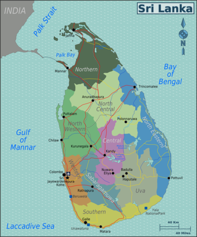
English: Map of Sri Lanka with provincial regions colour coded. SVG, Sri Lanka. |
| Date | |
| Source | :Image:Sri_Lanka_Regions_Map.svg |
| Author | User:(WT-shared) Burmesedays, Perry-Castañeda Library Map Collection Sri Lanka Maps, OpenStreetMap [1] |
| Other versions |
[]
|


![[1]](https://en.wikipedia.org/wiki/File:Sri_Lankan_Provinces_and_districts.PNG)
Licensing
This file is licensed under the Creative Commons Attribution-Share Alike 3.0 Unported license.
- You are free:
- to share – to copy, distribute and transmit the work
- to remix – to adapt the work
- Under the following conditions:
- attribution – You must give appropriate credit, provide a link to the license, and indicate if changes were made. You may do so in any reasonable manner, but not in any way that suggests the licensor endorses you or your use.
- share alike – If you remix, transform, or build upon the material, you must distribute your contributions under the same or compatible license as the original.
Original upload log
| This file was imported from Wikivoyage WTS. |
The original description page was here. All following user names refer to wts.wikivoyage-old.
- 2009-12-18 07:43 (WT-shared) Burmesedays[dead link] 2110×2534 (1072712 bytes) {{Imagecredit|credit=[[User:Burmesedays]], [http://lib.utexas.edu/maps/sri_lanka.html Perry-Castañeda Library Map Collection Sri Lanka Maps (Import from wikitravel.org/shared)
- 2009-12-18 07:58 (WT-shared) Burmesedays[dead link] 2110×2534 (1090377 bytes) (Import from wikitravel.org/shared)
- 2009-12-18 09:07 (WT-shared) Burmesedays[dead link] 2110×2534 (1103565 bytes) a few additions after refining the main article (Import from wikitravel.org/shared)
- 2010-02-15 11:59 (WT-shared) Burmesedays[dead link] 2194×2635 (1158175 bytes) changed colour scheme, much less nursery school now (Import from wikitravel.org/shared)
- 2011-08-01 08:55 (WT-shared) Burmesedays[dead link] 2000×2402 (1093709 bytes) some aesthetic improvements (Import from wikitravel.org/shared)
File history
Click on a date/time to view the file as it appeared at that time.
| Date/Time | Thumbnail | Dimensions | User | Comment | |
|---|---|---|---|---|---|
| current | 01:03, 19 December 2012 | | 2,000 × 2,402 (1.04 MB) | OgreBot | (BOT): Reverting to most recent version before archival |
| 01:02, 19 December 2012 |  | 2,194 × 2,635 (1.1 MB) | OgreBot | (BOT): Uploading old version of file from wts.wikivoyage; originally uploaded on 2010-02-15 11:59:01 by (WT-shared) Burmesedays | |
| 01:02, 19 December 2012 |  | 2,110 × 2,534 (1.05 MB) | OgreBot | (BOT): Uploading old version of file from wts.wikivoyage; originally uploaded on 2009-12-18 09:07:57 by (WT-shared) Burmesedays | |
| 01:02, 19 December 2012 |  | 2,110 × 2,534 (1.04 MB) | OgreBot | (BOT): Uploading old version of file from wts.wikivoyage; originally uploaded on 2009-12-18 07:58:32 by (WT-shared) Burmesedays | |
| 01:02, 19 December 2012 |  | 2,110 × 2,534 (1.02 MB) | OgreBot | (BOT): Uploading old version of file from wts.wikivoyage; originally uploaded on 2009-12-18 07:43:00 by (WT-shared) Burmesedays | |
| 02:53, 18 November 2012 |  | 2,000 × 2,402 (1.04 MB) | MGA73bot2 | {{BotMoveToCommons|wts.oldwikivoyage|year={{subst:CURRENTYEAR}}|month={{subst:CURRENTMONTHNAME}}|day={{subst:CURRENTDAY}}}} == {{int:filedesc}} == {{Information |description=Map of Sri Lanka with provincial regions colour coded. SVG, Sri Lanka * Map of... |
File usage
The following 2 pages use this file:
Global file usage
The following other wikis use this file:
- Usage on bn.wikivoyage.org
- Usage on el.wikivoyage.org
- Usage on eo.wikivoyage.org
- Usage on fr.wikivoyage.org
- Usage on he.wikivoyage.org
- Usage on hi.wikivoyage.org
- Usage on incubator.wikimedia.org
- Usage on it.wikivoyage.org
- Usage on ja.wikivoyage.org
- Usage on ru.wikivoyage.org
- Usage on uk.wikivoyage.org
- Usage on vi.wikivoyage.org
- Usage on zh.wikivoyage.org