File:TRTS Route Map after 2017.svg

Size of this PNG preview of this SVG file: 580 × 580 pixels. Other resolutions: 240 × 240 pixels | 480 × 480 pixels | 768 × 768 pixels | 1,024 × 1,024 pixels | 2,048 × 2,048 pixels.
Original file (SVG file, nominally 580 × 580 pixels, file size: 3.1 MB)
This is a file from the Wikimedia Commons and may be used by other projects. Information from its description page there is shown below.
Commons is a freely licensed media file repository. |
Summary
| Description |
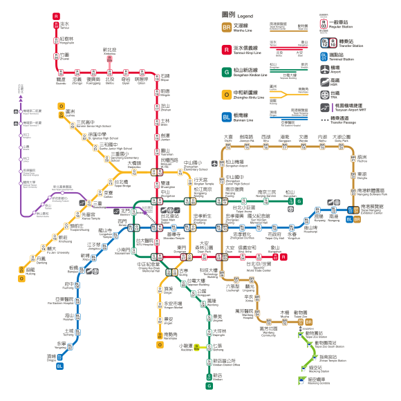
English: The route map of Taipei Metro after 2017.
中文:2017年新版臺北捷運路網圖 |
| Date | |
| Source | 臺北大眾捷運股份有限公司, Taipei Rapid Transit Corporation |
| Author |
臺北大眾捷運股份有限公司, Taipei Rapid Transit Corporation 再製及優化:Jack.T This vector image was created with Adobe Illustrator. |
Licensing

|
The copyright holder of this file allows anyone to use it for any purpose, provided that the copyright holder is properly attributed. Redistribution, derivative work, commercial use, and all other use is permitted. |
|
|
| “ | 為利各界廣為利用網站資料,臺北捷運公司(以下簡稱本公司)網站上刊載之所有資料與素材,其得受著作權保護之範圍,以無償、非專屬、得再授權之方式提供公眾使用,使用者得不限時間及地域,重製、改作、編輯、公開傳輸或為其他方式之利用,開發各種產品或服務(簡稱加值衍生物),此一授權行為不會嗣後撤回,使用者亦無須取得本公司之書面或其他方式授權。然使用時,應註明出處。 | ” |
File history
Click on a date/time to view the file as it appeared at that time.
| Date/Time | Thumbnail | Dimensions | User | Comment | |
|---|---|---|---|---|---|
| current | 05:59, 10 May 2018 | | 580 × 580 (3.1 MB) | Happy60907 | fix up. |
| 13:53, 21 April 2018 |  | 580 × 580 (3.2 MB) | Happy60907 | svg optimization & fix details. | |
| 03:58, 21 April 2018 |  | 580 × 580 (3.85 MB) | Happy60907 | fix color. | |
| 14:21, 3 April 2018 |  | 580 × 580 (3.07 MB) | Happy60907 | fix up. | |
| 14:56, 15 January 2017 |  | 580 × 580 (2.9 MB) | Happy60907 | Add white backgroung. | |
| 14:42, 15 January 2017 |  | 540 × 555 (2.89 MB) | Happy60907 | {{Information |Description ={{en|1=The route map of Metro Taipei after 2017.}} {{zh|1=2017年新版臺北捷運路網圖}} |Source =[[:zh:臺北市政府捷運工程局|中華民國臺北市政府捷運工程局, Department of Rapid Transit... |
File usage
There are no pages that use this file.