File:Taal Volcano satellite image.gif
No higher resolution available.
Taal_Volcano_satellite_image.gif (450 × 472 pixels, file size: 214 KB, MIME type: image/gif)
This is a file from the Wikimedia Commons and may be used by other projects. Information from its description page there is shown below.
Commons is a freely licensed media file repository. |
Summary
| Description |
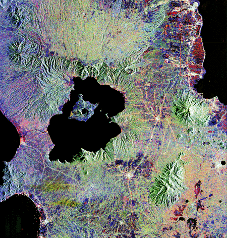
English: Lake Taal and Taal Volcano radar satellite image. From [1]. |
| Source | http://www.jpl.nasa.gov/radar/sircxsar/taal.html |
| Author | NASA |
| Other versions |

Licensing
| This file is in the public domain in the United States because it was solely created by NASA. NASA copyright policy states that "NASA material is not protected by copyright unless noted". (See Template:PD-USGov, NASA copyright policy page or JPL Image Use Policy.) | ||
 |
Warnings:
|
Original upload log
The original description page was here. All following user names refer to en.wikipedia.
- 2005-03-22 20:37 Worldtraveller 450×472×8 (218708 bytes) cropped version
- 2005-03-08 16:32 Worldtraveller 450×900×8 (367977 bytes) Lake Taal and Taal Volcano radar satellite image. From [http://www.jpl.nasa.gov/radar/sircxsar/taal.html]. {{PD-USGov-NASA}}
File history
Click on a date/time to view the file as it appeared at that time.
| Date/Time | Thumbnail | Dimensions | User | Comment | |
|---|---|---|---|---|---|
| current | 19:07, 10 January 2008 | | 450 × 472 (214 KB) | Rémih | {{Information |Description={{en|Lake Taal and Taal Volcano radar satellite image. From [http://www.jpl.nasa.gov/radar/sircxsar/taal.html].}} |Source=Transferred from [http://en.wikipedia.org en.wikipedia] |Date=2005-03-08 (first version); 2005-03-22 (las |
File usage
The following page uses this file:
Global file usage
The following other wikis use this file:
- Usage on az.wikipedia.org
- Usage on cs.wikipedia.org
- Usage on de.wikipedia.org
- Usage on en.wikipedia.org
- Usage on eo.wikipedia.org
- Usage on es.wikipedia.org
- Usage on fr.wikipedia.org
- Usage on he.wikipedia.org
- Usage on hr.wikipedia.org
- Usage on id.wikipedia.org
- Usage on ilo.wikipedia.org
- Usage on ja.wikipedia.org
- Usage on kk.wikipedia.org
- Usage on ko.wikipedia.org
- Usage on lv.wikipedia.org
- Usage on mk.wikipedia.org
- Usage on ms.wikipedia.org
- Usage on no.wikipedia.org
- Usage on pl.wikipedia.org
- Usage on pt.wikipedia.org
- Usage on ru.wikipedia.org
- Usage on tl.wikipedia.org
- Usage on tr.wikipedia.org
- Usage on uk.wikipedia.org
- Usage on zh.wikipedia.org