File:Tram map of Zwickau.xcf

Original file (990 × 971 pixels, file size: 1.49 MB, MIME type: image/x-xcf)
This is a file from the Wikimedia Commons and may be used by other projects. Information from its description page there is shown below.
Commons is a freely licensed media file repository. |
|
|
Summary
| Description |
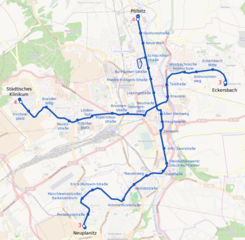
English: Tramway network of Zwickau, Germany Deutsch: Topographischer Netzplan der Straßenbahn Zwickau |
|||
| Date | ||||
| Source | openstreetmap.org | |||
| Creator |
OpenStreetMap contributors |
|||
| Permission (Reusing this file) |
OpenStreetMap data is available under the Open Database License (details). Map tiles are licensed under the Creative Commons Attribution-ShareAlike 2.0 license (CC-BY-SA 2.0).
This file is licensed under the Creative Commons Attribution-Share Alike 2.0 Generic license.
|
|||
| Georeferencing | If inappropriate please set warp_status = skip to hide. |
File history
Click on a date/time to view the file as it appeared at that time.
| Date/Time | Thumbnail | Dimensions | User | Comment | |
|---|---|---|---|---|---|
| current | 21:43, 21 December 2019 |  | 990 × 971 (1.49 MB) | Bürgerentscheid | updated to 2019-12-14 |
| 08:47, 18 April 2013 |  | 990 × 971 (1.63 MB) | Bürgerentscheid | {{XCF}} == {{int:filedesc}} == {{Information |Description=Tramway network of Zwickau |Date=2013-04-18 |Author= ~~~ |Source= Openstreetmap |Permission= |other_versions=thumb|left|Correctly rendered PNG-versioin }} [[Cat... |
File usage
The following page uses this file:
Global file usage
The following other wikis use this file:
- Usage on de.wikipedia.org
- Usage on de.wikivoyage.org
- Usage on en.wikipedia.org
- Usage on eo.wikipedia.org
- Usage on fa.wikipedia.org
- Usage on fr.wikipedia.org
- Usage on it.wikipedia.org
- Usage on ja.wikipedia.org
- Usage on nl.wikipedia.org
- Usage on pl.wikivoyage.org