File:Tripoint Basel (ws).jpg
Original file (1,672 × 2,689 pixels, file size: 673 KB, MIME type: image/jpeg)
This is a file from the Wikimedia Commons and may be used by other projects. Information from its description page there is shown below.
Commons is a freely licensed media file repository. |
Summary
Information, Source
| Description |
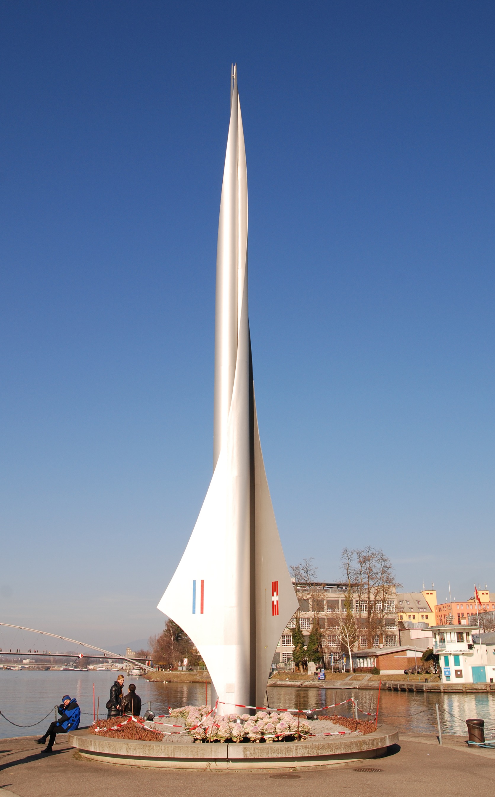
Deutsch: Dreiländereck Deutschland, Frankreich, Schweiz in Basel, links im Hintergrund die Dreiländerbrücke. Der Pylon wurde 1957 von Wilhelm Münger entworfen und steht auf Schweizer Boden - der Dreiländergrenzpunkt befindet sich im Rhein.
English: Tripoint Germany, France, Switzerland in Basel, in the background the Dreiländerbrücke. Pylon by Wilhelm Münger, 1957, placed on swiss territory; the point where the three borders join is in the middle of the river Rhine.
Français : Le tripoint Allemagne, France, Suisse à Bâle, en arrière-plan la passerelle des Trois Pays. Le Pylône créé 1957 par Wilhelm Münger est situé entièrement sur territoire suisse; le point des trois frontières se trouve dans le Rhin à mi chemin entre les rives. |
|
| Date | ||
| Source | Own work | |
| Author | Wladyslaw Sojka | |
| Permission (Reusing this file) |
|

.jpg)
Licensing

|
Permission is granted to copy, distribute and/or modify this document under the terms of the GNU Free Documentation License, Version 1.2 or any later version published by the Free Software Foundation; with no Invariant Sections, no Front-Cover Texts, and no Back-Cover Texts. A copy of the license is included in the section entitled GNU Free Documentation License. |
| This file is licensed under the Creative Commons Attribution-Share Alike 3.0 Unported license. | ||
| Attribution: Taxiarchos228 | ||
| ||
| This licensing tag was added to this file as part of the GFDL licensing update. |
| Object location | | View this and other nearby images on: OpenStreetMap |
|---|
.jpg¶ms=047.588525_N_0007.589761_E_globe:Earth_class:object_scale:781_type:landmark_region:CH_&language=en)
This image has been assessed using the Quality image guidelines and is considered a Quality image.
|
File history
Click on a date/time to view the file as it appeared at that time.
| Date/Time | Thumbnail | Dimensions | User | Comment | |
|---|---|---|---|---|---|
| current | 13:07, 12 December 2008 | | 1,672 × 2,689 (673 KB) | ALE! | == Information, Source == {{Information |Description=Tripoint Germany, France, Switzerland near Basel, in the background the Dreiländerbrücke |Source=German Wikipedia de:Datei:Dreiländereck Basel (ws).jpg |Date=17.02.2008 |Author=[[:de:Benutz |
.jpg)
File usage
The following page uses this file:
Global file usage
The following other wikis use this file:
- Usage on als.wikipedia.org
- Usage on ar.wikipedia.org
- Usage on be-tarask.wikipedia.org
- Usage on be.wikipedia.org
- Usage on ca.wikipedia.org
- Usage on de.wikipedia.org
- Schengener Abkommen
- Basel-Kleinhüningen
- Dreiländereck
- Diskussion:Dreiländereck
- Wikipedia:Lörrach/Basel 28. März 2009
- Benutzer:Bergfex2011/Französisch-Schweizerische Grenze
- Benutzer:DGWZ/Bilder
- Grenze zwischen Frankreich und der Schweiz
- Grenze zwischen Deutschland und Frankreich
- Dreiländerecke Europas
- Benutzer:Kpfiwa/Dreiländerecke Europas
- Pylon (Plastik)
- Wikipedia:WikiProjekt Schweiz/Kulturgüterschutzinventar/BS/Basel-Stadt
- Usage on el.wikipedia.org
- Usage on en.wikipedia.org
- Usage on es.wikipedia.org
- Usage on eu.wikipedia.org
- Usage on fa.wikipedia.org
- Usage on fr.wikipedia.org
- Usage on it.wikipedia.org
- Usage on ja.wikipedia.org
- Usage on lt.wikipedia.org
- Usage on pl.wikipedia.org
- Usage on pl.wiktionary.org
- Usage on ru.wikipedia.org
- Usage on sh.wikipedia.org
- Usage on sr.wikipedia.org
- Usage on sv.wikipedia.org
View more global usage of this file.
.jpg)
.jpg)