File:West Wales lines Map.png
Size of this preview: 800 × 480 pixels. Other resolutions: 320 × 192 pixels | 1,024 × 614 pixels | 1,280 × 768 pixels | 2,560 × 1,536 pixels | 3,750 × 2,250 pixels.
Original file (3,750 × 2,250 pixels, file size: 3.72 MB, MIME type: image/png)
This is a file from the Wikimedia Commons and may be used by other projects. Information from its description page there is shown below.
Commons is a freely licensed media file repository. |
Summary
| Description |
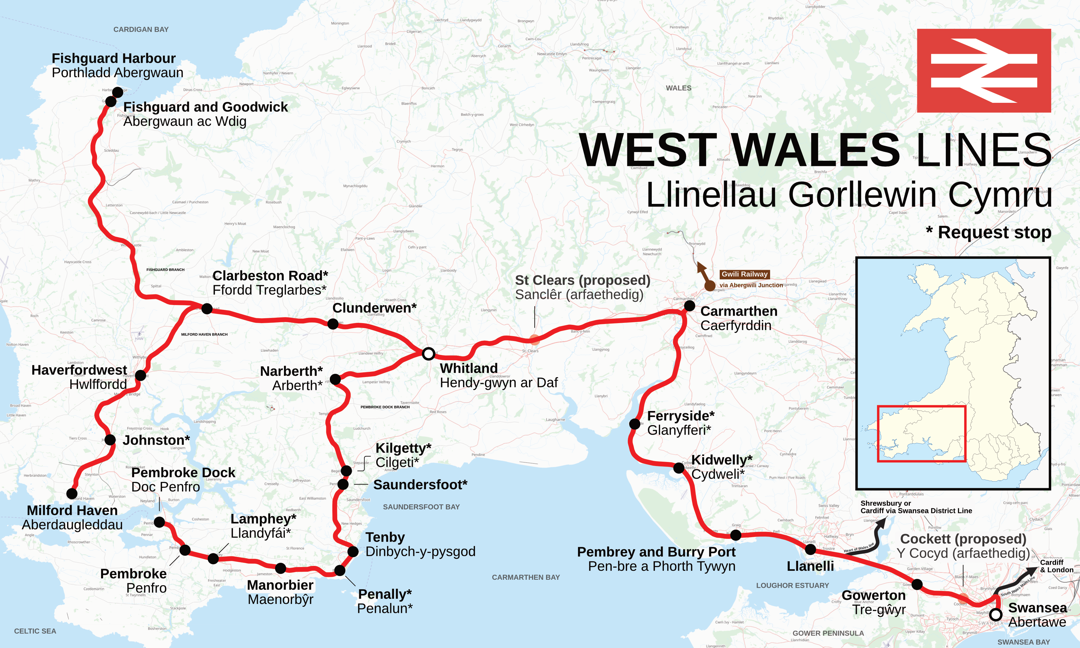
English: Map of the West Wales lines, a collection of railway line branches of the Wales and Borders franchise, west of Swansea, Wales to either Pembroke Dock, Milford Haven or Fishguard Harbour. Translations of stations in Welsh are labelled on the map underneath the English name, a lack of translation means the only name present is used in both Welsh and English. Request stops are marked with an asterisk (*). Heritage railway lines are coloured brown. Nearby heritage stations are also labelled. National Rail stations connecting to other lines are marked with a black and white roundel. Proposed stations have faded icons and labels. Map made to style produced by Rcsprinter123. This map may not be complete, and should not be used solely for navigation. |
|||
| Date | ||||
| Source |
Own work This image includes elements that have been taken or adapted from this file: This image includes elements that have been taken or adapted from this file: |
|||
| Author | DankJae; OpenStreetMap contributors | |||
| Permission (Reusing this file) |
Contains imagery from OSM Transport Map Style, produced by Thunderforest, released under CC-BY-SA 2.0. Maps © Thunderforest, Data © OpenStreetMap contributors. |
Licensing
I, the copyright holder of this work, hereby publish it under the following license:
This file is licensed under the Creative Commons Attribution-Share Alike 4.0 International license.
- You are free:
- to share – to copy, distribute and transmit the work
- to remix – to adapt the work
- Under the following conditions:
- attribution – You must give appropriate credit, provide a link to the license, and indicate if changes were made. You may do so in any reasonable manner, but not in any way that suggests the licensor endorses you or your use.
- share alike – If you remix, transform, or build upon the material, you must distribute your contributions under the same or compatible license as the original.
File history
Click on a date/time to view the file as it appeared at that time.
| Date/Time | Thumbnail | Dimensions | User | Comment | |
|---|---|---|---|---|---|
| current | 19:21, 4 May 2023 | | 3,750 × 2,250 (3.72 MB) | DankJae | Uploaded own work with UploadWizard |
File usage
The following 2 pages use this file:
Global file usage
The following other wikis use this file:
- Usage on en.wikipedia.org