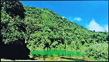
Juan Castro Blanco National Park (also known as Parque de Aguas) is a Costa Rica national park in North Costa Rica.
Understand
editThe park covers an area of 14,285 hectares of pristine jungle. There are limited man-made park improvements beyond the ranger station at the park entrance, so you must carry anything you need (and pack out any trash). It is a very large park and reaching the interior will require several days of backpacking. Hiring a local guide is recommended.
History
editThe park was created in 1992.
Landscape
editThe park is very mountainous with dense green foliage blanketing several mountains that are fully within the park boundaries, including three volcanoes: Volcan Porvenir (2,267 meters), Volcan Platanar (2,183 meters), and Volcan Viejo (2,060 meters). Platanar is an active volcano, Porvenir is dormant, and El Viejo is inactive. Mountain springs are the source of several small rivers whose rapids and waterfalls are popular scenic stops for backcountry hikers. The number of rivers and their headwaters are the reason many Ticos refer to the park as Parque de Aguas. Rivers born on the park's mountain slopes include Aguas Zarcas, Rio Platanar, Rio Tora, Rio Tres Amigos, and Rio La Vieja.
The park contains a natural lake, called Lago Pozo Verde.

Flora and fauna
editThe park contains a mind-boggling diversity of plant and animal life. Naturalists come for the variety of orchids and birds. At least 57 species of mammal have been spotted in the park including predators like the jaguar and ocelot, as well as gentler species like the tapir, coatimundi, sloth, howler monkeys (and other species of monkeys), red brocket deer and at least 22 species of bats. The Red brocket deer is an endangered species and will shy away from humans, so spotting one may be difficult.
Birdwatchers will spot some of the 233 species of birds, though some of those are migratory and only seen at certain times of the year. Endangered species found on the park include the Resplendent quetzal, and Great curassow.
Climate
editGet in
editThe nearest airport with commercial flights is in San Jose (SJO IATA), about 100 km south of the park. If you don't want to drive to the park, you can take a bus to Grecia and then use a taxi for the last 30 km of the trip. Taxis are likely to charge about US$100 since the roads are bad, take time to navigate, and might well result in a broken axle (or worse).
By car
editDriving to the park is the most convenient way to get there. In normal (dry) conditions, it is a 2-hour Drive from the San Jose area. To get there, drive west of San Jose on the Inter-american highway (CA-1). West of Alajuela, turn north on tertiary highway 141. Continue about 80 km to the village of San Carlos where you will turn east (right) onto the park access road. The road is in very poor condition, even for Costa Rica, where bad roads are a given. A 4WD truck is recommended.
Fees and permits
editCosta Rican citizens can enter the park for US$1. Foreign visitors pay US$10 to enter the park.
The park entrance is open daily from 8am to 4pm.
Get around
editHike. Good boots, dry socks and long pants are recommended.
See
edit- flower farms - near the park are large farms with enormous greenhouses growing roses, tulips, orchids and other flowers for foreign florists. Flowers are harvested daily and shipped immediately by air freight
Do
editHiking
editAn extensive trail system is available with different distances and degrees of difficulty, depending on your ability. A paved, wheel-chair accessible trail is available for handicapped naturalists. Popular trails in the park are:
- Sendero Piedra Ventana (Window Stone Trail): Easy, short hike leading to a natural stone window with amazing views of the surrounding valleys and mountains. Great place for some Instagram worthy travel pics.
- Sendero El Mirador (Lookout Trail): Leads to a natural overlook where you can see the point where of the Cordillera Central and the Cordillera de Tilarán mountain ranges come together.
- Sendero Laguna Hule (Hule Lagoon Trail): Scenic trail leading to the spectacular Hule Lagoon, a quiet natural spot for picnicking and birdwatching.
- Sendero El Chompipe (El Chompipe Trail): A more challenging hike, this trail climbs to higher levels of the mountain, offering views of high-altitude ecosystems and stunning vistas of the forests and valleys below.
Buy
editEat
editA small cafe at the park entrance sells light meals and drinks. Backpackers should bring what they need.
Drink
editBring an adequate supply of drinking water. Natural water sources are abundant and backpackers may be able to rely on filtering devices or chemical treatment.
Sleep
editA camping area is available near the park entrance and ranger station. Additional designated camping areas are in other parts of the park. Camping permits can be obtained at the ranger station at the main park entrance. Backcountry camping is permitted in the interior of the park.
Towns around the periphery of the park offer different types of lodging, from hotel rooms to rustic cabins. A range of rooms can be found in the towns of Ciudad Quesada and Zarcero.
