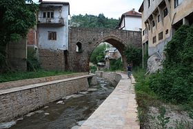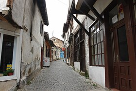

Kratovo (Macedonian: Кратово) is a town of just under 7,000 residents in northeastern North Macedonia. It is on the western slopes of Mount Osogovo inside the crater of an extinguished volcano. In addition to its scenic location, it is best known for its medieval bridges and towers.
Understand
editBy Macedonian standards, Kratovo is not a major destination for tourists. By European standards, Kratovo is as far off the beaten path as you can get. But rest assured, if you venture out to this corner of the Balkans, you will find more history and character packed into Kratovo than other towns many times its size.
History
editSome archaeological excavations suggest the Kratovo area was settled in Roman times or earlier, but it did not achieve great importance until it fell under the Kingdom of Serbia in the late 13th century when gold, copper, lead, silver, and iron were mined in and around Kratovo. Coins were also minted in the town during Serbian rule.
In 1390, Kratovo was taken over by the Ottomans. It would remain within the Ottoman Empire for the following five centuries. By the 16th century, it was among the most important mining centers of the Ottoman Europe. It was home to many wealthy and educated men. The mint of Kratovo, opened in the end of the 15th century, became the second-largest producer of coins in the empire. Some of these coins are on display at the Museum of Archaeology in Skopje.
The mint of Kratovo ceased operations around 1660. Seven mines, however, were still active in the town and its vicinity until the Hapsburg forces, after temporarily taking the town, retreated and burned it down. Mining activity in the region then shifted to Probištip and Zletovo. It only recovered within Kratovo around the early 1800s, though on a smaller scale. Its population was around 5,000 to 6,000. After the mines finally shut down for good in 1882, the population fell to 4,500, half of which were Turks. After Kratovo was taken by the Serbian army in 1912, much of the Turkish population left, leaving the town with under 2,000 inhabitants.
Now part of North Macedonia, Kratovo has about 6,900 residents and is the seat of the municipality of the same name which includes 30 surrounding villages. Virtually all of the residents of the municipality are ethnic Macedonians and Macedonian Orthodox Christians.
Get in
editGet around
editEverything in the town of Kratovo is walkable and it happens to be the best way to see the town. Be prepared for some uphill and downhill walking on Kratovo's interesting terrain. If driving, parking can be a bit of a struggle in Kratovo's narrow streets.
See
edit
- 1 Kratovo City Museum, ☏ +389 031 482 015. M-F 8:30-16:30. Founded in 1993 within a historic Ottoman-era home.
- 2 Church of Saint John the Baptist (Црква „Св. Јован Крстител“). The current church exists on the place of an older one that was burned down in 1689 during an uprising. Much of the valuable religious items were saved prior to the church's destruction. The church was rebuilt in 1836 under the design of Andrej Damjanov and its iconostasis was made of walnut and golden leaf. The church is made of stone, has a portico and a pitched roof with a cupola.
- 3 Church of Saint George of Kratovo (Црква „Св. Ѓорѓи Кратовски“). Built in 1925, this church is dedicated to Saint George of Kratovo who was burned at the stake in 1514 for not accepting Islam as his religion. It has one cupola over the entrance.
Bridges
editBridges have connected the town across the Kratovo River and its tributaries for centuries. Five of the medieval stone bridges remain.
- 4 Argulički Bridge (Аргулички мост). Crossing a tributary of the Kratovo River in southern Kratovo, this stone bridge consists of a single rounded arch.
- 5 Čaršiski Bridge (Чаршиски мост). Located between the Grofčanski and Jokširski bridges, the Čaršiski Bridge has a rounded arch unlike the two neighbouring it which have pointed arches.
- 6 Gornoamamski Bridge (Горноамамски мост). The easternmost of the bridges.
- 7 Grofčanski Bridge (Грофчански мост). The westernmost of the medieval bridges, the Grofčanski Bridge has two arches, under one of which the river runs. The bridge was built in the early 1700s.
- 8 Jokširski Bridge (Јокширски мост). The stone single-arch bridge connects the tannery neighborhood to the Sultan Murat neighborhood.
- 9 Radin Bridge (Радин мост). This bridge is newer than the other five, having been built in 1833 by Skopje nobleman Havzi Pasha. It crosses one of the Kratovo River's tributaries in the southern end of town.

Towers
editKratovo once had 12 towers, five on the right side of the river and seven on the left. Today, six remain including Hadži Kostov Tower and the five below. Of these, the Clock Tower is the easiest to access as it houses exhibits of the Kratovo City Museum.
- 10 Clock Tower (Саат кула). One of the six remaining towers of the Middle Ages and Ottoman period. Built in 1372, it is divided into three floors. The uppermost was used as a home for the local Turkish beys (lords). The tower, now held by the Kratovo City Museum, is open to the public and contains exhibits. The terrace at the top is also open to visitors, providing views of the town and its surroundings.
- 11 Krste's Tower (Крстева кула). This square tower is in very good condition. On the entrance side, it has four windows and two balconies.
- 12 Simikj's Tower (Симиќева кула). This tower is located north of the Kratovo River and stands 13 m (42 ft) high and 6 m (20 ft) wide.
- 13 Srez Tower (Срезка кула). Located just west of Krste's Tower, the Srez Tower is in rougher shape than its neighbour and could use a new roof.
- 14 Zlatko's Tower (Златкова кула). Built in 1365, the tower is named after its last owner Georgi Zlatkov. The rectangular tower with three floors stands 6 m (20 ft) tall.
Neighboring villages
edit
Kratovo Municipality contains several historic villages. Important sites within Kratovo Municipality:
- 15 Stone Dolls of Kuklica (Камени Кукли) (village of Kuklica, 11 km west of Kratovo). This natural wonder, consisting of 15 larger (10 m / 32 ft tall) and 120 smaller stone pillars, was probably created by erosion and other climate influence. However, the legend connected to this phenomenon says that the figures are in fact wedding guests who were turned into rocks.

- 16 Cocev Kamen (Цоцев камен), village of Šopsko Rudare. Cocev Kamen is within Kratovo Municipality but, because of some mountains, is a shorter drive from Kumanovo than from Kratovo. The hilltop cave site of volcanic origin may have been inhabited as early as Paleolithic times. Some of the walls are painted, similar to such caves found in Bulgaria and Italy. It may have also been used as an astronomical observatory.
- 17 Golemo Gradište (Големо Градиште), village of Konjuh. This archaeological complex contains remains of sites dating from Late Antiquity and the medieval era. It is thought to be the location of the late Roman fortified town Tranupara. Situated on a hill near the Kriva River, the more prominent ruins include an early Christian church from around the 4th century and a medieval church from the 14th century. The former mostly consists of short walls and foundations; a church dedicated to St John the Baptist was built next to it in 1955. The latter is largely still standing and has had a new roof installed atop it. Traces of the original frescoes as well as some decorative ceramics are found inside. While the original dedication is unknown, it has been named after St George.
- 18 Church of the Holy Mother of God (Црква „Св. Воведение на Пресвета Богородица“), village of Šlegovo. In the centre of the historic village of Šlegovo is this 1861-built church. Several old icons are within the church, including a couple that predate its construction. Made entirely of stone, the church features a long porch with several arches and a very nice bell tower.
- 19 Church of Saint Nicholas (Црква „Св. Никола“), village of Šopsko Rudare. This site has two churches, an older one dating from the 16th century and a newer one built in 1939. The older church is simple on the outside with a pitched roof but contains significant frescoes on the inside. The newer St Nicholas is a prominent structure with a large dome, though it is in surprisingly rough shape.
Do
edit- 1 Kratovo City Stadium (Градски стадион Кратово). With a capacity of 1,800, it is home to FK Sileks of the First Football League.
- 2 Walk the quay. A stretch of the riverside walkways in central Kratovo has been renovated, creating a lovely promenade from Hotel Kratis to the Jokširski Bridge. It provides a different vantage point to see the town's old homes and bridges, as well as the greenery along the river.
- 3 City Park (Градски Парк). Kratovo's main park, on the south side of St George of Kratovo Street.

- Two hours walking Tour around old Kratovo., ☏ +389 78208117, donevskijakim@yahoo.com. Two hours walking Tour around old Kratovo.
Eat
edit- 1 Gostilnica Kaj Spiro, Saint George of Kratovo 3, Kratovo 1360, ☏ +389 77 706 108. This restaurant, which means "the guesthouse at Spiro's", sometimes has live music. Located in the City Park.
- 2 Kanu, ☏ +389 31 482 954. Noon to 1am daily. Traditional cuisine.
- 3 Persydo Cafe, ☏ +389 70 470 172.
- 4 Restaurant Etno Kuklica, s.Kuklica, ☏ +389 70 579 810, kuklicaetno1@gmail.com.
Drink
edit- 1 Persydo Bar & Lounge, Strahil Dosev 13, Kratovo 1320, ☏ +389 70 470 172. (Not the same place as Persydo Cafe)
Sleep
edit- 1 Hotel Kratis, St George of Kratovo 8, Kratovo 1360, ☏ +389 31 481 201. The only hotel in Kratovo. It is located at the confluence of two tributaries into the Kratovo River. It has a restaurant and bar.
- Kuklica Etno, s.Kuklica, ☏ +389 70 579 810.
- Etno House Shancheva (Shancheva House), Str.Skopska No.9 (Old central Kratovo), ☏ +389 70975684, kratovskakuka@yahoo.com. It has 3 rooms and 7 beds. €10.
Go next
edit- Probištip is just south of Kratovo, home to Lesnovo Monastery in a neighboring village
- Kumanovo is North Macedonia's third-largest city, home to some important churches in its surroundings as well as the prehistoric megalithic observatory Kokino.
- Kriva Palanka is a small town in the country's northeast corner, near the Bulgarian border.

