Machu Picchu


Machu Picchu is the site of an ancient Inca city, high in the Andes of Peru. At 2,430 metres (8,000 ft) above sea level, this ![]() UNESCO World Heritage Site is often referred to as “The Lost City of the Incas”, is one of the most familiar symbols of the Incan Empire, and is one of the most famous and spectacular sets of ruins in the world.
UNESCO World Heritage Site is often referred to as “The Lost City of the Incas”, is one of the most familiar symbols of the Incan Empire, and is one of the most famous and spectacular sets of ruins in the world.
Understand
editHistory
editThese remarkable ruins were rediscovered by the scientific world in 1911 by the American archaeologist Hiram Bingham, who was led to the site by locals. Perched dramatically 1000ft above the Urubamba river, Machu Picchu is a ![]() UNESCO World Heritage Site. It is also the end point of the most popular hike in South America, the Inca Trail.
UNESCO World Heritage Site. It is also the end point of the most popular hike in South America, the Inca Trail.
The story of Machu Picchu is quite a remarkable one; it is still unknown exactly what the site was in terms of its place in Inca life. Current researchers tend to believe that Machu Picchu was a country resort for elite Incas. At any given time, there were not more than 750 people living at Machu Picchu, with far fewer than that during the rainy season. The Incas started building it around AD 1430 but it was abandoned as an official site for the Inca rulers a hundred years later at the time of the Spanish conquest of the Inca Empire.
One thing that is clear is that it was a remarkably well hidden place, and well protected. Located far up in the mountains of Peru, visitors had to travel up long valleys littered with Inca check points and watch towers. Remarkably, the Spanish conquistadors missed the site. However, many people are said to have knowledge of the ancient city as it was referred to in some text found in the 20th century. However, it was not until Bingham that Machu Picchu was scientifically discovered. He was on a trip sponsored by the Yale University, actually looking for the last Inca capital, which was at Vilcabamba, which Bingham also rediscovered but overlooked in favor of the more impressive Machu Picchu.
Machu Picchu was declared a Peruvian Historical Sanctuary in 1981 and a UNESCO World Heritage Site in 1983. In September 2007, Peru and Yale University reached an agreement regarding the return of artifacts which Hiram Bingham had removed from Machu Picchu in the early twentieth century. Since it was not plundered by the Spanish when they conquered the Incas, it is especially important as a cultural site and is considered a sacred place.
Machu Picchu was built in the classical Inca style, with polished dry-stone walls. Its primary buildings are the Intihuatana, the Temple of the Sun, and the Room of the Three Windows. These are in what is known by archaeologists as the Sacred District of Machu Picchu.
Climate
edit| Machu Picchu | ||||||||||||||||||||||||||||||||||||||||||||||||||||||||||||
|---|---|---|---|---|---|---|---|---|---|---|---|---|---|---|---|---|---|---|---|---|---|---|---|---|---|---|---|---|---|---|---|---|---|---|---|---|---|---|---|---|---|---|---|---|---|---|---|---|---|---|---|---|---|---|---|---|---|---|---|---|
| Climate chart (explanation) | ||||||||||||||||||||||||||||||||||||||||||||||||||||||||||||
| ||||||||||||||||||||||||||||||||||||||||||||||||||||||||||||
| ||||||||||||||||||||||||||||||||||||||||||||||||||||||||||||
Daytime highs are quite constant around the year, but the nighttime lows are much more pronounced during the Southern Hemisphere winter. As is common in the tropics, most of the yearly rain falls during the rainy season which in Machu Picchu is October to April. Due to the altitude, extremely hot temperatures that one may expect this close to the Equator are absent. However these two factors contribute to very high levels of UV-radiation (nearby Cuzco actually has the highest average level of UV-radiation in the world for any major city) so do take precautions. its mostly between 12 and 27 °C.
Landscape
editFlora and fauna
editBoth are abundant and varied. Typical plant life in the historic reserve of Machupicchu includes pisonayes, q'eofias, alisos, puya palm trees, ferns and more than 90 species of orchids.
The fauna in the reserve includes the spectacled bear, cock-of-the-rocks or "tunqui", tankas, wildcats and an impressive variety of butterflies and insects unique in the region.
The lay of the land, the natural surroundings and the strategic location of Machu Picchu lend this monument a fusion of beauty, harmony and balance between the work of the ancient Peruvians and the whims of nature.
Get in
edit
Visitors to Machu Picchu typically either hike the Inca Trail or leave by rail from Cuzco or Ollantaytambo, either on a day trip, or overnighting in Aguas Calientes. The only ways to get to Aguas Calientes are by train or on foot — no roads go there.
Overnighting allows you to visit the park early or late in the day and avoid the worst of the crowds, and on sunny days, gives you a nice window of reprieve from the beating sun. The wet season in Peru is from November (often only really taking off in December) until the end of March, so then it is best to include a few extra days for flexibly dealing with delays.
.jpg)
From Aguas Calientes, there are two ways to reach the ruins: by bus or walking (free steep hike), as described below.
Depending on when you arrive, the site may be quite crowded or nearly deserted. The busiest periods are in the dry season (June–August), with the slowest being in February, the height of the rainy season, when the Inca Trail is closed. Most visitors arrive on package tours and are in the park between 10:00 and 14:00.
To access the site, you must have both a bus ticket (unless you plan on hiking) and ticket for Machu Picchu - which are available on in advance from the official website or from the ticket office in Aguas Calientes. Machu Picchu tickets are not sold at the entrance gate and are limited to 1000 a day when buying in person.
It is obligatory to bring your passport to enter Machu Picchu. Even if your ticket is on your national id card, the officer will still ask for your passport.
By bus from Aguas Calientes
editIf arriving by train into Aguas Calientes, walk out of the 1 train station and keep going roughly straight through the warren of handicraft stalls and over a foot bridge to the 2 bus departure area. Frequent busses leave to the ruins (US$12 each way (Jan 2024), US$24 round-trip for adult foreigners) starting at 05:30. Bus tickets can be bought in two 3 Consettur ticket booths along Avenida Hermanos Ayar, payment in cash or MasterCard, Visa, AMEX, UnionPay. You will need to show an ID/passport when buying a bus ticket.
There's often a queue to the buses, so if you're intent on being on the first one up, you should arrive at least 90 minutes early. The journey takes around 30 minutes to slowly wind around the switchbacks and up to the park. Buses depart when full, which typically means they run quite regularly. At popular times, there may be a lengthy queue for the busses, so plan the return trip accordingly in order not to miss train departures.
By foot from Aguas Calientes
editFrom Aguas Calientes to get to the ruins themselves it is also possible to walk along a route similar to the one that the buses run, which will take about 1½–2 hours up, and around an hour back down. This route is mainly stairs, connecting the switchbacks that the buses take. It is a strenuous and long hike but is very rewarding, recommended to start around 05:00 when the gate at the foot opens, to make it to the top before sunrise. The descent is fairly easy, just take care when the steps are wet. Keep alert for the bus drivers that rarely brake for pedestrians.
By foot via the Inca Trail
edit
Hiking the 4 Inca Trail is a great way to arrive as you first see the city through the Sun Gate (instead of arriving from below as you do from Aguas Calientes). The four-day and two-day hikes are controlled by the government. Travelers should be fit enough to walk for days and sleep in tents. Every traveler must travel with a tour agency because of the rules and regulations of entering the park. The Peruvian government has imposed a 500-person pass limit per day on Inca Trail traffic. Passes sell out far in advance, particularly for the high season.
There are also other options available for hiking to Machu Picchu. Both of these alternatives can be booked a couple days in advance when you arrive in Cuzco and can be much cheaper options and good ways to stay away from the crowds before getting to Machu Picchu.
The Salkantay Trek is a 5-day trek through the Salkantay Mountain Pass. It is possible to do this trek without an organized tour. The scenery is amazing and if you go in the rainy season you will be rewarded with dozens of waterfalls. Though, at the same time, you will be wet for the most part anyways.
Accommodation and transport until reaching Machu Picchu costs about US$150 (Jan 2024) when going it alone. Expect organized tours to charge a premium. Do your research in Cuzco and pick the tour company you feel most comfortable with. Some groups will offer slightly more (sleeping bag included, etc.) than others.
The Inca Jungle Trek is an agency tour. The three day trek that begins with a drive to the top of a mountain and then a bike ride down to the bottom. A full day of hiking follows the next day to Aguas Calientes.
The "backdoor" route used is also an option for independent travelers wishing to go it alone. Minivans and busses are cheap (S/15-30) from "Terminal Santiago" in Cusco and take you to either Santa Maria or Santa Teresa. Santa Maria is further away from Aguas Calientes than Santa Teresa but is a nice option for those wishing to hike an alternative Inca trail used locally. The walk takes you through the mountains and tiny villages, even people's farms and offers impressive views of the valley. You can end up in Santa Teresa the same day and there are villages, such as Huacayupana and Quellomayo en route which offer an alternative view of local life and accommodation if you don't make it to Santa Teresa that day. Walking on from here to Santa Teresa is along the river (May - November) and by road during rainy season, although it is advisable to get advice before taking this route between December and April due to severe weather. From Santa Teresa to Hidroelectrica is a 25-minute taxi or minibus ride and from here you can walk the 2- to 3-hour flattish trek to Aguas Calientes which is one of the nicest parts of the journey.
Additionally, many local tour operators have since opened up alternate trekking options that allow for similar trekking opportunities in the area. Most visit other Inca ruins, not as well excavated, and finish with the train trip up to see Machu Picchu at the end. One such option is the Choquequirao Trek, which starts in Cacharo and ends in Los Loros or the Cachiccata Trek which starts in Racca and ends in Cachiccata.
Fees and permits
edit.jpg)
Tickets are available for purchase online at the government website and in person from the ticket office in 5 Aguas Calientes. A government-maintained real-time availability tracker is available to see how many tickets are still available for purchase in Aguas Calientes for a given day. Keep in mind though that tickets bought in person may only be used the day after they are purchased.
Online tickets can be purchased several months in advance and require a credit card. If an error is shown at the payment process, most probably you try to purchase the tickets (1) not during Peru office hours or (2) from outside of Peru. Try using a VPN service with a server located in Peru. Tickets may also be reserved online for payment in person at the ticket office in 6 Cusco, which must be paid within five hours of the transaction being made. Tickets are no longer available for purchase in person at the ticket office in Cusco.
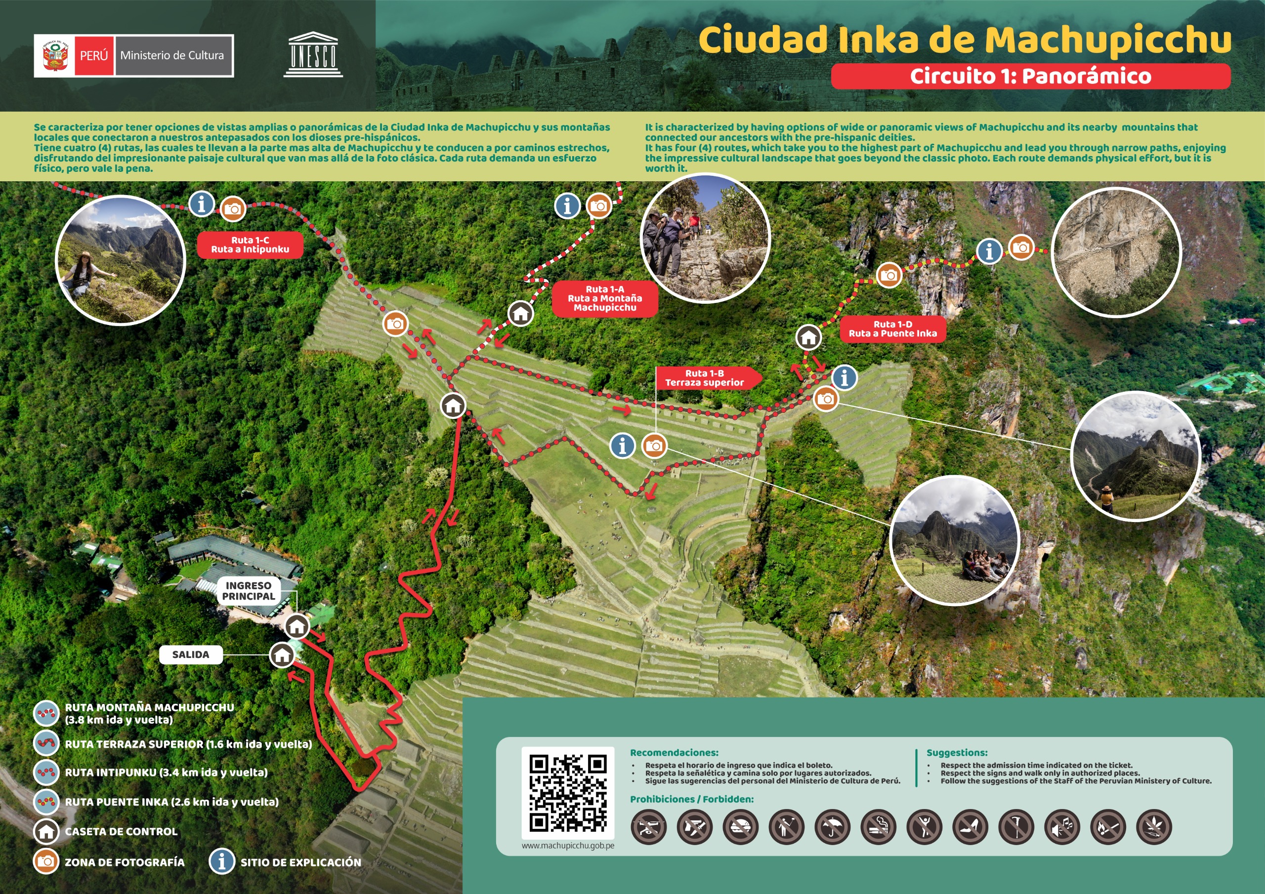
Tickets are divided into ten routes grouped into three circuits, reduced from 5 on 1 June 2024. The ticket you buy will be for only one route within one of these circuits. To see all of Machu Picchu, you will need to buy multiple tickets at a price of S/152 (Nov 2024) each. A reduced price of S/77 (Nov 2024) is available for students with an ISIC card or minors. Citizens of Peru, Ecuador, Bolivia or Colombia pay S/112 (Nov 2024). When preparing your budget, do not forget to include train tickets and bus tickets, and perhaps food at the site.
- Circuit 1 is the panoramic route. Unlike the other circuits, it does not give access to the rest of the site.
- Route 1-A visits the upper and lower viewing platforms, and includes an add-on for Machu Picchu Mountain.
- Route 1-B visits the upper and lower viewing platforms only. Ideal if you have very little time.
- Route 1-C visits the upper and lower viewing platforms, and includes an add-on for the Sun Gate. Available only during the high season.
- Route 1-D visits the upper and lower viewing platforms, and includes an add-on for the Inca Bridge. Available only during the high season.
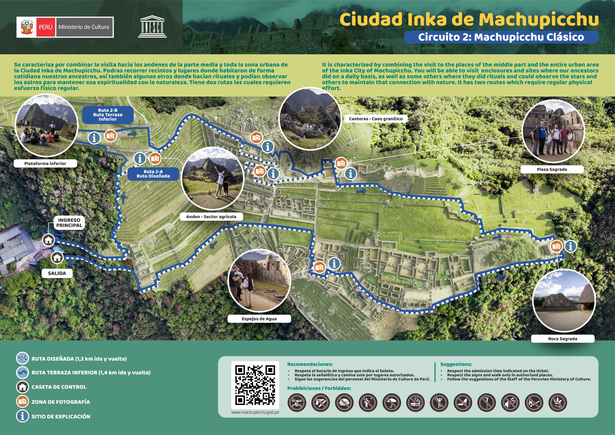
- Circuit 2 is the classic route, which passes through the entire urban area of Machu Picchu.
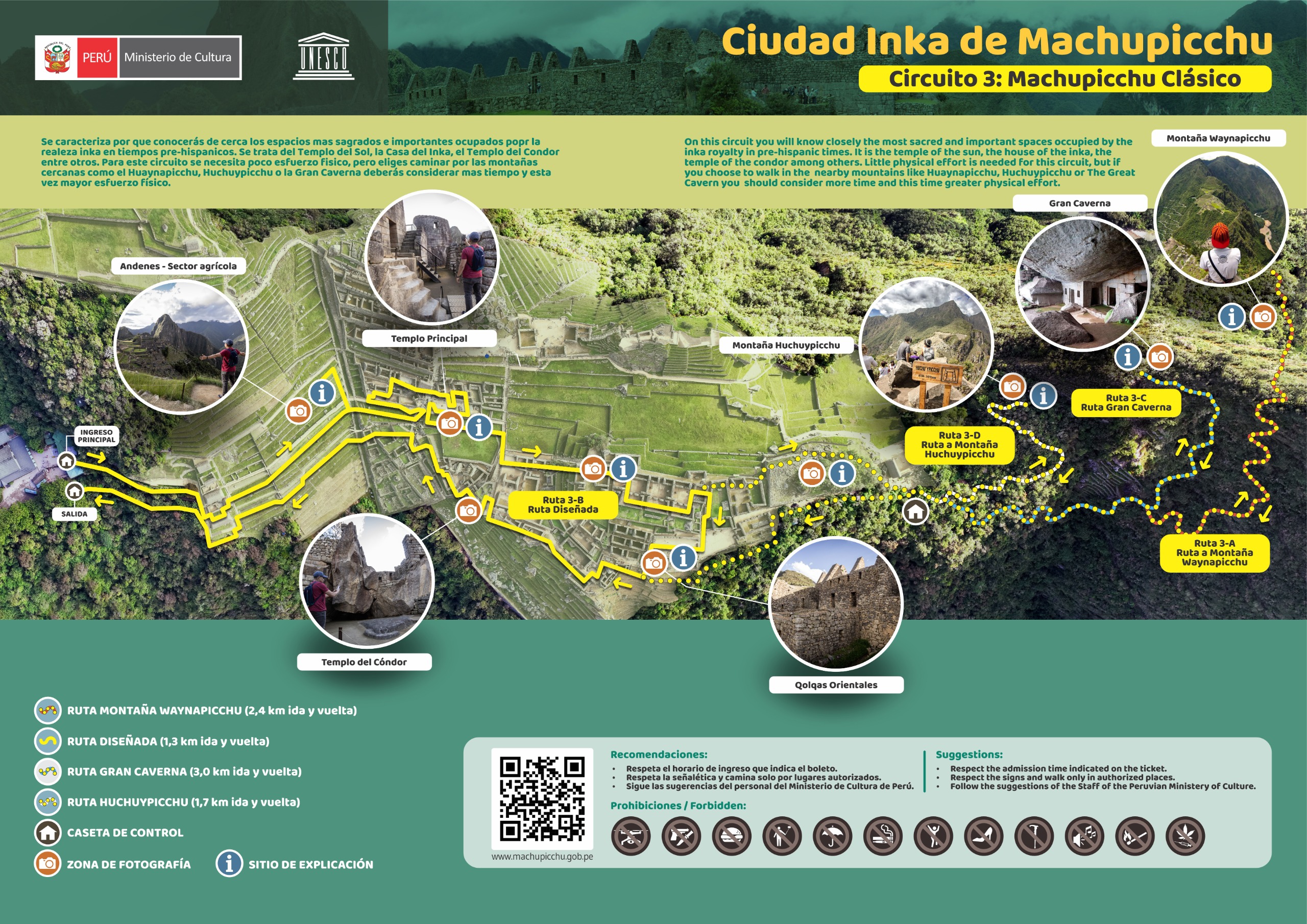
- Circuit 3 is the "royal" route (Machupicchu realeza), which includes the most important sites used by the Inca royalty.
- Route 3-A loops around the lower city and includes an add-on for Huayna Picchu Mountain.
- Route 3-B loops around the lower city only.
- Route 3-C loops around the lower city and includes an add-on for the Great Cave and the Moon Temple. Available only during the high season.
- Route 3-D loops around the lower city and includes an add-on for Huchuy Picchu Mountain. Available only during the high season.
Be sure to bring your passport, as it is requested upon entry. Some travelers have been able to enter with other forms of ID. There is a popular stamp booth as you exit where you can prove to your friends you've been there, but you are advised not to stamp your own passport as this could invalidate it. Instead, bring an expired passport or a small booklet.
Only small packs are allowed in the park (20x35x40cm), but there is a luggage storage at the entrance for S/5 (Nov 2024). Note that it is not allowed to bring food into Machu Picchu. If your pack is checked, any food you carry may be confiscated.
There are no toilets within the site, but they are available right outside the entrance and are clean and well maintained. They cost S/2 (Nov 2024).
You can book guides through travel agencies or find guides at the entrance. The price depends on the circuits. While you can easily get a shared guide for the classic Circuit 2 for 10 USD per person, you will probably need a private guide for Circuit 3, as it is more special. Private guides cost around 50 USD. The guides are trained and officially registered. You can recognize them as they have an ID-Card like permit on a keylace.
Get around
edit
There are no vehicles of any kind in the park, so bring some comfortable walking shoes, especially if you plan to do any of the hikes such as Huayna Picchu. No walking sticks are allowed in the main area, except for visitors who have difficulty walking; however, they are allowed on Huayna Picchu, where they help significantly with the climb, especially down. The main ruins are fairly compact and easily walk-able.
Many of the paths are one-way, so be careful – you can easily find yourself missing a spot you wanted to see or forced into the exit accidentally.
Mobility-disabled visitors can arrange wheelchair/accessible tours via private tour groups, and see a substantial portion of the site.
See
editAll the views from above, but be sure before you do it that there are no clouds (early in the morning is always cloudy, it is recommended to do it at noon).

Take your time walking around the site, there are many places to see and explore. Although it is not required, taking a guided tour does provide a deeper insight into the ancient city, its uses, and information on the geography of it. As of Mar 2018, a 2-hr guided tour is S/200, but can be negotiated down depending on how busy the site is. If you wish to save money, you can team up with other tourists who would like to have a guided tour. As a cheaper alternative to a guide, there are several apps providing virtual audio tours of the site.
Relatively little is known about the history and uses of the ruins, and some of the stories told by the guides are based on little more than imaginative hearsay.
- 1 Sun Gate (Intipunku) – if you've just arrived via the Inca Trail, this will be your first experience of the ruins. Others can backtrack from the ruins along the trail and up the hill. From here you can see back down each valley offering excellent views, if it is cloudy you cannot appreciate the view (avoid doing it or just wait for a clearance). It's a fairly strenuous hike (probably 1-1½ hours each way) but well worth it.
- 2 Temple of the Sun – Near the summit of the main city, the stonework on the temple is incredible. Look closely and you will see that there are a variety of stone walls throughout the city. Most are rough stones held together with mud, the common stone walls found throughout the world. But many buildings or parts of buildings are done with the more distinctive and impressive closely-fit stonework. The temple is the absolute pinnacle of this technology. Observe it from the side, descending the stone staircase in the main plaza.
- 3 Intihuatana – A stone carved so that on certain days, at dawn, the sun makes a certain shadow, thus working as a sun dial. From Quechua: Inti = sun, huatana = to take, grab: thus grabbing (measuring) the sun. (pronounce 'intiwatana'). While most early risers view the sunrise from the watchtower, the Intihuatana offers the best vistas, and you'll have it all to yourself.
- 4 Temple of the Three Windows
- 5 Main Temple
- 6 Temple of the Condor – A temple, including some stones arranged in a way that kind of looks like a condor with wings outstretched, with a prison complex behind it – look closely: between the wings of the condor is a chamber with grooves cut in the stone to secure manacles, a walkway behind where a torturer may walk to whip the prisoner's backs, and a scary looking pit to let the blood of prisoners drain. Clearly the condor was a symbol of cruel justice, but a sanitized version is told for the benefit of tourists.
- 7 Fountains – As a testament to Inca workmanship, these 500-year-old spring-fed fountains still function to this day. It is speculated that these provided drinking water to the city or were for ritual bath purposes.
Do
edit
If you got some energy in you, there are a few great hikes involving a bit of legwork. Do make sure that you've taken the time to acclimate to the elevation either in Cuzco or Aguas Calientes for a couple days before exerting yourself too much, especially on Huayna Picchu.

- 1 Huayna Picchu (Wayna Picchu). Towering above the north end of Machu Picchu is this steep mountain, often the backdrop to many photos of the ruins. It looks a bit daunting from below, and it is a steep and difficult ascent, but most reasonably fit persons should be able to make it in about 45 minutes. There are rough stone steps and in some places steel cables for holding. That said, expect to be out of breath, and take care in the steeper portions, especially when wet, as it can become dangerous quickly. There's a tiny cave near the top that must be passed through, it is quite low and a rather tight squeeze. Take care at the peak, it can be somewhat precarious, and those afraid of heights may want to hang out just below. The entire walk is through beautiful landscape, and the views from the top are stunning, including birds eye views over the whole site. The angle gives you a good sense of the layout of Machu Picchu. There's also a few ruins near the top. 400 tickets are available per day and must be reserved via the Machu Picchu website or via your tour company (at least a month beforehand). Tickets are purchased in one of two groups: 07:00-08:00 and 10:00-11:00. The later option sometimes has better views as it leaves time for the fog to clear. You must check in and out at the second ticket booth, and people start lining up about a half hour or even more before their start time. S/48, added to the price of your ticket.


- Note: trail is closed as of Jan 2024 with no set re-opening date. For serious hikers who have the time and energy and long for a sparkle of solitude, from Huayna Picchu you can continue on an extra hike to the 8 Moon Temple (Templo de la Luna), which is built into the side of a cave, and the nearby 9 Great Cave (Gran Caverna), where women would come to pray to Pachamama (Mother Earth). This hike is one of your best bets for getting away from Machu Picchu and Huayna Picchu crowds: both sites are much quieter than Machu Picchu and allow you to see Inca architecture at its finest without feeling like you're drowning in other tourists. This longer hike, which goes in a loop and is much more tiring but no more challenging than the regular hike to the peak and back, takes about twice as long: a total of about four hours (three if you're a fast hiker), versus about two hours just to the peak and back. It's a long walk and adventurous hike involving two ladders. Some may find that the sites aren't really rewarding, but unexpected wildlife can be seen (wild spectacled bears have been reported). This hike is also quite interesting because partway through you leave behind the mountain terrain and enter a more conventional forest. The caves can be reached by hiking down the trail from the peak of Huayna Picchu (which includes some semi-harrowing but fun near-vertical descents). Your hike back up from the temples will then be exhausting. Be sure to bring plenty of water and snacks for this long hike.
.jpg)
- 2 Machu Picchu Mountain – This is the mountain on which Machu Picchu is located and you can walk to the summit south of the ruins (3040m - Machu Picchu is at around 2,400-2,600m, Macchu Picchu Pueblo (Aguas Calientes) is at around 2,000m). Like Wayna Picchu you will have spectacular views, and it will cost you less. It used to have no entrance fee, but as of November 2017, tickets have to be purchased up front, just like for the site itself. Tickets can be purchased in advance, for one of two groups: 07:00-08:00 or 09:00-10:00. The path to Machu Picchu Mountain can be found along the path to the Sun Gate. Machu Picchu Mountain is among the least visited sites at Machu Picchu, which will give you the opportunity to get away from the tourist crowds. For the round trip you should plan on 2½-3 hours. Bring lots of water, as the hike is strenuous. You are not officially allowed to bring food, but may regret not having some snacks. Expect a hike similar to the one from Macchu Picchu Pueblo to the site in style, but longer, and with steeper steps. The trail is spectacular, even if you don't reach the summit.
- 3 Inca Bridge. Historically there were two paths into Machu Picchu. The Inca Trail is one of the paths, the other is through the Inca Bridge. This bridge (logs/drawbridge) is built across a sheer cliff which would control access to the city. The walk to the Inca Bridge is short and can be found to the south west of Machu Picchu.
Eat and drink
edit

You are not allowed to bring any food into the park, and must check it in at the luggage storage at the entrance. In practice, however, bags are rarely searched, and most people have no problem getting a bottle of water and some snacks in with them, which you'll definitely want, especially if you're planning to stray from the central set of ruins. Buy these beforehand, as they're much more expensive at the site itself. Don't even think of leaving a shred of trash behind you. If you are thinking of walking from 06:00 to 17:00, you will need at least 1.5 litres of water.
Once in the site, there are no food or drinks for sale, though it is possible to leave and return.
- 1 Concession stand (Above the luggage storage). Near the entrance of the site, it is appropriately overpriced given their captive audience, a meal is US$40 (Jan 2024).
- 2 Tinkuy Buffet Restaurant (At Belmond Sanctuary Lodge), ☏ +51 84 211038. 11AM–3:30PM. A casual lunch buffet. The food is decent and the restaurant quite busy at peak times. A discounted train and buffet ticket is available on certain trains from Peru Rail. After lunch, do a circuit of the restaurant's poster-size photographs from Hiram Bingham's 1911 "discovery" of Machu Picchu. US$40.
- 3 Tampu Restaurant Bar (At Belmond Sanctuary Lodge). 5:30AM-9AM, noon-3PM, 6:30PM-9:30PM. Open to hotel guests only, also high prices.
Sleep
editBecause this is a protected park, further construction in the area is nearly impossible. Thus, there is only one very expensive hotel at the site itself. Almost everyone who wants to overnight near Machu Picchu books a hotel in nearby Aguas Calientes.
- 1 Machu Picchu Sanctuary Lodge, KM 7.5, Carretera Hiram Bingham, ☏ +51 84 211038, perures.fits@belmond.com. This superbly over-priced hotel is the only option for sleeping at the park. There are two equally expensive restaurants on site, and 2 suites that have partial views of the ruins. If money is not a concern, consider staying here as it gives you more time to spend on the site, but otherwise you can find less expensive accommodation elsewhere. $655+ (February 2017).
Go next
editBack to town (in order of size and distance):
- Aguas Calientes – if spending the night or want a bath or another hike
- Ollantaytambo
- Cusco
In the area:
Further afield:
- Kuelap, Amazonas, Northeast Peru – largest pre-Inca ruins in South America
- Tiwanaku, Bolivia – similar stonework, from a different civilization