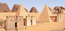
Northern Sudan consists of the three states of Sudan known as Northern, Red Sea and River Nile.
Cities
edit- 1 Atbara — a main city best known as a train junction and cross roads connecting the eastern and central states of Sudan with the North.
- 2 Dongola — the capital of the Northern (Al-Shemaliah) state, the major economic activity there is agriculture, different kinds of vegetables and fruits are grown on both banks of the Nile.
- 3 Ad-Damir (Ed Damer)
- 4 Merowe
- 5 Port Sudan
- 6 Shendi — a historical city, home of the Al Jaleen tribe
- 7 Suakin — port in north-eastern Sudan on the west coast of the Red Sea
- 8 Wadi Halfa
Other destinations
edit- 1 Kerma — capital of the Kerma culture, which dates back at least 5500 years. Kerma is one of the largest archaeological sites in ancient Nubia and houses a large museum.
- 2 Meroë — home to over 200 Nubian pyramids, a UNSECO World Heritage site.
- 3 Musawwarat es-Sufra — large Meroitic temple complex dating back to the early Meroitic period of the 3rd century BC.
- 4 Naqa — ruined ancient city of the Kushitic Kingdom of Meroë, UNSECO World Heritage site.
- 5 Old Dongola — deserted medieval city with numerous ruins.
- 6 Sedeinga pyramids — group of at least 80 small pyramids built around 1 BCE.
- 7 Sabu-Jaddi — cluster of more than 1600 rock drawings from different historical periods expanding for more than 6000 years through different eras of Nubian civilization.
- 8 Halayib Triangle is a northern region disputed between Sudan and Egypt. As most of it is de facto controlled by Egypt it is described as a continuation of their Red Sea coastal strip. This is simply to assist travellers and does not imply endorsement or refutation of either country's claims.

- 9 Tombos — archaeological site along the Nile with several well preserved tombs and rock carvings, set in an ancient quarry.
Understand
editMainly Arab Muslim district.
Get in
editBy plane
editThe only major airport within Northern Sudan is in Port Sudan. Apart from that the only nearby international airport is in the capital Khartoum.
By road
editIn Shemaliah State, one of the longest is the highway that connects the capital city Khartoum with Shandi, Atbara and Port Sudan (the third biggest city in the country).
By train
editThere's a reliable railway connection from the capital Khartoum as far north as Atbara. The route is served by the daily Nile Express train. Other routes, including the connecting train from and to the ferry in Wadi Halfa, run on an irregular schedule.
By ferry
editThe most reliable way to enter Sudan from Egypt is via the weekly ferry from Aswan in Egypt to Wadi Halfa. It runs on Mondays to Sudan and back on Wednesdays, and costs US$33 per person. The boat is old and crowded with people and goods but it takes in some magnificent views (including that of Abu Simbel). Food and drink are available on board. There are frequent ferries from Saudi Arabia to Port Sudan.
Get around
editSee
edit
This region is home to many important historical sites of Nuba and Meroe civilizations, new discoveries are happening all the time. The areas of Meroe, Musawwarat-Es-Sofra, and Wad Ben Naqa are home to impressive collections of Meroitic temples, pyramids, and palaces.
The Red Sea coast of North Sudan includes two national parks, Sanganeb Marine National Park and Dungonab Bay – Mukkawar Island Marine National Park which together form a world heritage site.

