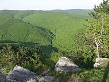
Papuk Nature Park is a 33,600-hectare nature park in Slavonia Eastern Croatia, about 80 km west of Đakovo.
Understand
editPapuk is a nature preserve in the region of Slavonia, Eastern Croatia. It is one of Croatia's least well known natural wonders, and thus does not have much tourism most of the time. Nevertheless, Papuk is a beautiful park of nature, featuring Slavonia's highest peak, stunning forestry, and beautiful waterfalls.
History
editIn 2007, the Papuk Geopark became the first Croatian geopark (an area with an expressed geological heritage and a strategy for a sustainable economical development), the 30th member of the European Geoparks Network, and a member of the UNESCO-assisted Global Geoparks Network.
Landscape
editThe Papuk Geopark spans two counties, Požega-Slavonia and Virovitica-Podravina, and includes upland forests of the Papuk and Krndija mountains, and edges of agricultural fields.
The Papuk mountains belong to the Slavonia highlands which are in Pannonia, a low-lying area of Slavonia. Although the Slavonia highlands are not higher than 1,000 meters, their presence is very noticeable in the landscape. This is because the surrounding alluvial fields are at around 100 m height above sea level, while the hillsides are only 100 m above the fields. The highlands are mostly covered with forests, which differentiates them from the surrounding landscape.
Within the Slavonia highlands, the Papuk Mountain stretches from west to east and is the most spacious and most interesting mountain. From the main mountain-ridge well intended are two spurs and a tract watered by a drainage basin in the direction north south. As a remarkable point, emphasis lies on peaks Točak (887 m), Papuk (953 m), Ivačka glava (913 m), Češljakovački vis (820 m), and Kapovac (792 m), which are spread out continuously, and act as a drainage divide between the numerous tributary streams flowing to the river Drava to the north, and the river Sava to the south.
Flora and fauna
editClimate
editThe climate of Papuk is variable between the seasons. Summer is mild to warm, spring and autumn are mild/cool, and winter is cold and snowy.
Get in
editVisitors will most likely start from Zagreb. From Hungary it is possible to come across several border crossings to Koprivnica, Virovitica, Donji Miholjac or Osijek.
By car from Zagreb, take the Ivanja Reka-Lipovac highway, and exit at Nova Gradiska. Follow road 51 north to Požega, and turn left on road 4253 to Velika - the entrance to the center of the Nature Park.
By train from Zagreb, it is also possible to reach the park from the station in Nova Hoca.
On the north side of the park there are two most entrances: Voćin and Orahovica.
If you come from Osijek by car or train, the first entrance to Park is Orahovica or Slatinski Drenovac.
Fees and permits
editGet around
editSee
editThe Visitors' Center is in Velika, 14 km from Požega. Velika is the main gate to Papuk Geopark.
The center has permanent and occasional exhibitions, and us close to thermal pools, the Lapjak educational path, mountaineering paths, runway for paragliding and the Sokoline rocks for free climbing.
The permanent exhibition in the centre has biologic, geologic and historical exhibits from the area of geopark. Visitors have an opportunity to discover the geologic inheritance through posters, geologic samples, crystals, and a very rich collection of fossils.
Biologic exhibits among others include nests of different birds and collection of insects. Archaeological exhibits include the objects from the late Stone Age, early Iron Age, and also many glass products from glass manufactures from the 18th century.
The center is open on working days.
Do
edit- Trekking
- Mountain biking
- Hiking
- Geocaching
- Paragliding: the Pliš paraglide runaway sits on the southern slopes of Papuk mountain.
- Sport climbing: At Sokolina near Velika there are 10 sports climbing routes with heights up to 12 m.
