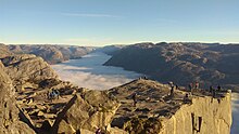
Ryfylke is a district in Rogaland county, Norway. Ryfylke includes the islands, fjords, valleys and uplands around the inner part of the great Boknafjorden.
Regions
edit
Ryfylke is a rural region in Rogaland county, southern Fjord Norway. Approaching from the south, you encounter the famous fjords from Ryfylke. in the south you will first meet Lysefjorden, known for Preikestolen (Pulpit Rock) and mount Kjerag in the inner part of the fjord. The Ryfylke National Tourist Route is one of 18 tourist routes established by the National Road Authorities in Norway, running from Oanes (road 13), Lysefjorden in the south up to Røldal in Hardanger in the north (road 520). This route offers a beautiful and lush landscape, with fjords, green isles and skerries, colourful heathlands and tranquil cultural landscapes, screes and boulder fields, towering mountains and sheer cliffs.
Already in the 19th century the wild and pristine landscape of Ryfylke attracted its first tourists, English salmon fishermen went to Suldalslågen river and exploring travellers went along the so-called Discovery Route.
Today it continues to tempt travellers to great outdoor adventures. The highlights and attractions are many. You can fish in the rovers and streams and sheltered fjords, savour fruit orchards in full flower, go on mountain walks or enjoy more extreme sports. Here are many charming villages and small friendly towns that merit a visit, and ferries crossing the fjords invite to a break in the driving.
At Haukalivatnet lake (near Lysefjorden) there is a distinct end moraine presumably created by a prehistoric glacier. This moraine led professor Jens Esmark (in 1824) to formulate the theory of an ice age over Scandinavia and other parts of the world. Esmark believed that climate changes due to the changes of the earths orbit caused ice ages.
Cities
editOther destinations
editUnderstand
editGet in
editIn the summer, tourist boats offer day trips from Stavanger through Lysefjorden and the surrounding waters.
Norled run ferries from Stavanger to Tau[dead link], roughly ever 40 minutes in the summer, which take cars, bikes and foot passengers. Most ferries are met by the local 100 bus into Jørpeland [dead link].
General information on public transport in the region is available on the Ryfylke tourist information site[dead link]
Get around
editSee
edit


Itineraries
editLysefjorden the first fjord when you arrive from the south, is one of the most famous fjord in Norway. The 40 km long fjord surrounded by impressive mountains and cliffs carved out during successive Ice Ages is the dominant feature of Forsand municipality.
For a magnificent view of the fjord, walk to the top of Preikestolen (Pulpit Rock), 600 m above sea level. The walk takes about two hours from the parking lot (paid parking) near the Preikestolen Mountain lodge, the return is 1.5-2 hours. More than 130 000 people made this walk in the summer season of 2010. Season. April - October. You can buy a through ticket for the ferry from Stavanger and then private coach to the mountain lodge from Tide Resier [dead link], costs about kr 250, tickets available online, or from a stand at the ferry terminal, or buy on the ferry. Alternately, buy a return ferry ticket to Tau, then take the local Kolumbus bus to the lodge, about kr 100 for the ferry then kr 160 for the return bus ticket. Tickets for the Boreal bus aren't valid on the Tide Resier one, not vice versa, so check timetables before deciding which to book on!
Kjerag mountain plateau rise up to 1084 m above the innermost part and southern shore of the Lysefjord. One dramatic attraction is Kjeragbolten, a boulder wedged into a crack in the mountain. Kjerag also attracts base jumpers and rock climbers. The trail starts from Øygardstølen by Lysevegen Road (closed in Winter, often until June). 10 km hike, climbs 570 m, Good shoes and physical health are advised. Season June - September.
Lysevegen from Lysebotn in the bottom of lysefjorden in east up to Øygardstøl count 27 exciting hairpin bends, open in summer.
The National Tourist Road Ryfylke starts as Road 13 from Oanes by the northern mouth of the Lysefjord and goes 183 km through Ryfylke up to Håra, Røldal in Hardanger, the last part crossing Røldalsfjellet mountains as Road 520 (closed in winter)
Along Svandalsfossen waterfall by road 520 (National Tourist Road Ryfylke) you can follow the waterfall up close while climbing the striking stairs.
Allmannajuvet gorge near Sauda will get a visitor center in 2012. here you can walk on the old mine road and get a guided tour into the dark zink mines.
Do
editSleep
edit- 1 Energihotellet, Nesflaten at Suldal lake (Road 13). Hotel within a major hydro power station (hence the name "Energy hoel"). On road 13 through Ryfylke between Stavanger and Odda.
Eat
editDrink
editStay safe
editGo next
edit- Hardanger is Ryfylke's neighbour in the north. Road 13 through Ryfylke and Hardanger is one of the great scenic roads in Norway.
- Sunnhordland is Ryfylke's and Hardanger's neighbour on the other side of Folgefonna glacier in the outer areas of Hardangerfjord.
- Stavanger and the Jæren flatlands with endless sandy beaches.

