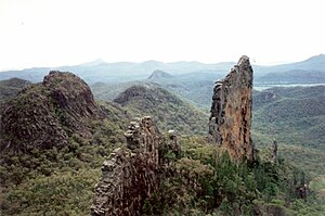
Warrumbungle National Park is in Warrumbungle Shire, Gilgandra Shire and Coonamble Shire of New South Wales, Australia and the park was the first within Australia to be certified as a Dark Sky Park by the International Dark Sky Association.
Understand
edit
History
editThe park was founded as a reserve in 1953, and in 2006, it was added to the list of National Heritage. Much of the park was destroyed by fire in early 2013 but it has much recovered since then.
Landscape
editThe national park is based on the geographical Warrumbungle Mountain Range, often shortened to "the Warrumbungles", and thus the park name is often heard in the plural.
Flora and fauna
editThe park lies within the Pilliga Important Bird Area, so identified by BirdLife International because of its importance for a range of woodland bird species, many of which are threatened. Other types of fauna include the typical Eastern Australian fauna.
Climate
editVisitor information
edit- Park website
- Warrumbungle Visitor Centre, 4261 John Renshaw Parkway, Warrumbungle, ☏ +61 2 6825 4364, warrumbungle.np@environment.nsw.gov.au. 9AM-4PM (closed noon-1PM).
Get in
editThe nearest towns to the park are Baradine, Coonabarabran, Coonamble, Gilgandra, Gulargambone, and Tooraweenah. Access via Coonabarabran to the east is by 27 kilometres via the John Renshaw Parkway, which is paved or via Coonamble to the west, access is by a 57km road with some gravel sections.
Fees and permits
editThere is a fee of $8 per vehicle per day. Country NSW Parks passes are also valid here.
Get around
editSee
editObservatories
edit- 1 Siding Spring Observatory, Observatory Rd, Coonabarabran (27km west of Coona town centre, perched at the edge of the Warrambungles.), ☏ +61 2 6842 6363. With an elevation of about 1160m, not just with the numerous telescopes, there is also a visitors' gallery and exhibition area open to the public which also incorporates a café and souvenir shop. During NSW school holidays, guided tours of the site are offered. Groups of over 15 adults may apply for Behind the Scenes walking or bus tours. An Open Day is held annually in October, offering talks about astronomy and tours inside many of the telescope domes which are open to the public on this one day of the year. These tours include the AAT 3.9M, UK Schmidt, iTelescope.Net, 2.3M ANU and the LCGTN 2M telescope facilities. Siding Spring also has multiple telescopes ranging in size from 0.45m to about 4m, all which has to show something unique.
Lookouts
edit- 2 Grand High Tops lookout, Grand High Tops Track, Tonderburine. From this lookout, you'll see the remains of the once Warrumbungle volcano. It does take a trek to come here, but it's worth the view.
- 3 Whitegum lookout, Whitegum Track, Warrumbungle. Has some spectacular views of the volcanic landscape, although from a different perspective.
- 4 Bluff Mountain lookout, Bluff Mountain Track, Warrumbungle. More views of volcanic peaks and domes.
- 5 Fans Horizon lookout, Fans Horizon track, Warrumbungle. Gives you some views of the Warrumbungles spires and domes.
- 6 Febar Tor, Goulds Circuit Track, Tonderburine. Another lookout viewing a different rock.
Do
editBuy
editEat
editThere aren't any places to eat. Bring your own food.
Drink
editSleep
editThere are four main campsites. All camping in the park is only permitted after obtaining a permit. There is a visitors centre for bookings and keys to a number of huts. There are free electric barbecues available however firewood is not supplied or to be collected within park grounds.
Lodging
editCamping
editOnce you obtain a permit to do so, you may camp in one of the park's four main campsites.
- Balor Hut campground, ☏ +61 2 6825 4364. Bookings required via park website. This campground features a historic walkers' hut.
Backcountry
editStay safe
editGo next
edit- Dubbo is the closest city.

