Northern Chile

Northern Chile is among the driest parts of the world. It includes the regions of Arica-Parinacota, Tarapacá, Antofagasta, Atacama and Coquimbo.
Cities
edit

- 1 Antofagasta — a relaxed mining city with lots of leisure activities and a large car industry
- 2 Arica — the "city of the eternal spring" offers beautiful beaches, and a very dry, mild climate
- 3 Calama — "copper capital" of the country with the giant mine of Chuquicamata nearby
- 4 Caldera — gateway to Bahía Inglesa, a picturesque and lovely beach to just enjoy the sun
- 5 Copiapó — gateway to Bahía Inglesa and Desierto Florido
- 6 Coquimbo — includes the Union Flag of the UK in its coat of arms
- 7 Iquique — a seaside city with long beaches and a picturesque city centre
- 8 La Serena — gateway to the Pisco Valley
- 9 Pisco Elqui — famous for the national schnapps produced here, Pisco
- 10 Punta de Choros — gateway to the National Humboldt Penguin Reserve to see Humboldt penguins, bottlenose dolphins, sea lions, sea otters, and many types of seabirds
- 11 Putre — gateway to Lauca National Park
- 12 San Pedro de Atacama — gateway to popular attractions such as Salar de Atacama, El Tatio Geysers and Valle de la Luna
- 13 Vicuña — supposed to be best stargazing in the world, but nowadays just a regular town on the way to Pisco Eqlui
Other destinations
edit- 1 Lauca National Park – in the Andes with large volcanic mountains, and its neighbour Las Vicuñas National Reserve just south.
- 2 Llullaillaco National Park – home to Llullaillaco Volcano.
- 3 Valle de la Luna – an impressive dry desert landscape.
Understand
editNorthern Chile has been thriving on the mining industry since the middle of the 19th century. It started with saltpetre which came to an abrupt end at the beginning of the 20th century when the synthetic production of nitrates was invented. The remains of the old production sites are still impressive and provide an insight into the hard life of the workers. Nowadays copper has taken over the role of Chile's main export good and is mined in giant open pits. Furthermore some minerals like lithium are produced in the salt lakes.
Many visitors come to see the spectacular landscape of the Andean Highlands. Snow-covered mountains more than 6,000 m high contrasting with blue lakes, mountains showing all shades of red and brown due to their volcanic origin, and a number of geothermal areas with hot springs and geysers are among the natural attractions of the region.
On the more relaxing side, Arica and Iquique offer long sandy beaches at the Pacific coast.
Get in
editBy plane
editAirports in this area with several flights daily from Santiago:
- Andrés Sabella Gálvez International Airport (ANF IATA) in Antofagasta – also connections to/from Peru
- Chacalluta International Airport (ARI IATA) in Arica – also connections to/from Bolivia
- El Loa Airport (CJC IATA) in Calama
- Diego Aracena International Airport (IQQ IATA) in Iquique – also connections to/from Bolivia
- La Florida Airport (LSC IATA) in La Serena
By car
editThe national highway #5 (Panamericana) is the main artery of the region connecting central Chile with Antofagasta, Iquique, Arica and Peru. Access from Bolivia (La Paz and Oruro) is via highway #11 passing Lauca National Park and Putre towards Arica. The alternate route from Oruro via Colchane and highway #15 towards Iquique is less used and thus in better condition (at least on the Chilean side). Access from northwestern Argentina (Salta) goes along Chilean highways #23 or #27 to San Pedro de Atacama and Calama.
Get around
editBy car
editThe highways outside of the highlands are generally in good condition as are the main highways through the highlands to the neighbouring countries. Other roads in the highlands can be very rough. Before moving along such roads individually it is best to enquire locally about road and weather conditions.
Renting a truck or 4WD in Antofagasta or Calama is a great idea if you are 3-5 people and want to explore the region around on your own. This will save you a lot of money on expensive tours in San Pedro de Atacama, and rental cars are much cheaper in Antofagasta or Calama. But due to the rough terrain, it is strongly recommended to get a 4WD or truck, instead of a regular, unless you plan to stay on proper roads.
By bus
editBuses connect all cities and also provide connections to neighbouring countries. There are no longer any passenger trains in Northern Chile.
See
edit- 1 Atacama Desert. The driest place in the world.


- 2 Bahía Inglesa (about 20 minutes away by collectivo (1,000 pesos) or hitchhiking away from Caldera). A picturesque and lovely yet windy beach if you just want to enjoy the view, sun and maybe a beer at one of the bars facing the sea.
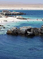
Bahía Inglesa

- 3 Rocas Negras (3 km south from Bahía Inglesa along the beach). A set of pitch black rocks in between sand of shells along the beach, where you can find many pecten shells of up to 10 cm in diameter.
- 4 Desierto Florido (Flowering desert). A desert area and nature reserve that becomes a beautiful and impressive field of flowers once a year when the rain has fallen.
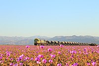
Desierto Florido - 5 Gigante de Atacama (The Tarapacá Giant) (15 km east of national highway #5 (Panamericana) along national highway #15 towards Colchane; the intersection of the dirt road is signposted). The largest geoglyph in the region. A remarkable planning effort considering that it is hundreds of years old. You get the best overall picture when looking on Google Earth though; therefore you could stop there if you are driving along these roads any way but it's doubtful whether it really pays to come here from a long distance. Free.
- 6 La Portada (15 km north of Antofagasta, use your bus when coming into Antofagasta to get off at the junction towards the sight, after or before Antofagasta depending on where you come from; otherwise, local bus 103 goes closest to the sight from Antofagasta center. Or any bus heading for Mejillones will let you off at the road cross nearby, from where it is a 3-km walk to see the natural stone arch in the sea.). The yellowish rock gate stands in the sea at along a picturesque and wild cliff coast. If you bring a mattress and sleeping bag, there are many dry places to camp and stay over night.

La Portada - 7 Mano del Desierto (75 km south of the city). A sculpture of giant hand rising from the sand.
- 8 Oficina Humberstone (Humberstone and Santa Laura Saltpeter Works) (50 km east of Iquique in the Atacama Desert along highway A-16 at the intersection with national highway 5 (Panamericana)). 09:00-19:00. This UNESCO site is an old residential and production site from the days of the saltpetre era. Few residential houses are furnished, but most of the site is still in remarkable condition due to the dry atmosphere. Allow 1-2 hr to stroll around the huge area. 3,000 pesos.
- 9 Parque Paleontológico Los Dedos (beyond Rocas Negras), ☏ +56 976160891. Tu-Su 11:00-19:00. In the hot middle of nowhere about 1 km from the beach, an outdoor museum for fossils of penquins, sharks, crocodiles, whales and much more.
.jpg)

Do
edit- 1 Isla Damas (120 km north at a coastal village called Choros). There you can swim, walk along trails and to lookout points or go scuba diving and snorkeling. It is worth seeing the penguins and sea lions. Also, dolphins also frequent the area. Once back on the mainland, stay the night at Punta de Choros, where cabins and campsites will allow you to enjoy warm seaside evenings.
- 2 Parque Nacional Fray Jorge (Bosque de Fray Jorge National Park) (You can enter the Fray Jorge National Park from the south by taking the North Pan-American highway to mile 241.7, and then taking a long side road to the west for 13.6 miles up to the main park’s gate. This is a dirt road, but in good conditions year round.). Jan–Feb: daily 09:00-17:00; Otherwise: 09:00-16:00. Fray Jorge National Park Nacional comprises acres at altitudes of up to 2,188 m in the coastal area located miles east from most beautiful places to visit are Hydrophilic trail is very mouth river. The best time to visit is on weekends from late October to November, during the entire flowering period. It will take you at least 4 hours to visit. There are picnic area and campsites for 8,000 pesos per night, and a lodge for 5 persons is 25,000 pesos. Domestic animals are not allowed. Bring a coat since the forest is cold. The admission ticket is 1,600 pesos, children 600 pesos.
- 3 Nevado Ojos del Salado. A dormant volcano with an altitude of 6,893 m, it is the highest point in Chile, second highest mountain outside Asia, and the world's tallest volcano. Sitting at the Argentinian border, the mountain has a second, almost exactly as high summit on the Argentinian side. Some 500 m below the summit you can see a lake, which is believed to be the highest lake in the world. Ojos del Salado has remarkably gradual slopes and the surrounding dry Atcama desert means that there's usually very little snow and ice. This has made the mountain a popular place for setting world altitude records for cars, indeed cars and even a truck have been driven up to altitudes above 6,000 m. Maybe more importantly, it's possibly the highest place in the world you can reach by just hiking (30 km from the nearby road, plus 2,400 m ascend; only the very last part to the summit is a somewhat challenging scramble). This high, altitude sickness is most certainly a risk — don't ascend too fast! Because of the general extremeness of the high-altitude-low-humidity environment, it's quite problematic to undertake the 8-15 days long adventure solo. Various travel agencies offer support services (such as the catering and transportation), prices per person seem to start at around 2000-2500 pesos.
Eat
editDrink
editStay safe
editBe aware that you can easily get up to more than 4,000 m (13,000 ft) of altitude on normal roads. Get accustomed to this by getting higher in reasonable steps. If you join one of those one-day excursions from Arica to Lauca National Park then you are very likely to suffer from altitude sickness which must be taken seriously.
In the mountainous areas, mobile phone coverage is usually limited to the vicinity of towns. If you set out on a track road other than one which connects towns or popular tourist attractions then it might be a good idea to take a satellite phone with you. Filling stations are rare so make sure you know your options.