Diving at 13th Apostle

The dive site 13th Apostle is an offshore rocky reef in the Llandudno area on the Atlantic seaboard of the Cape Peninsula, near Cape Town in the Western Cape Province of South Africa.
Understand
edit
This granite reef and pinnacle has been known to exist for many years, as there is a break over it in a large swell, but no details were reported until an exploratory party visited it on 3rd October 2010, to investigate what had shown up on a side-scan sonar image from a reef survey by the Council for Geoscience as a massive mound of rock. What they found is a huge granite corestone tor with a variety of interesting topographical features, on a low profile rocky bottom with sand patches.
Position
editName
editThe name "13th Apostle" is a reference to the position at the end of the mountain range called the Twelve Apostles, south of Table Mountain.
Depth
editMaximum depth is about 24 m and the top of the pinnacle is about 6 m. Average depth on a dive is likely to be about 15 to 18 m
Visibility
editVisibility is variable, and can be in excess of 15 m on a good day.
Topography
edit
At 18 m the reef extends about 200 m from north west to south east. The top of the reef is a ridge running roughly true east-west, and approximately 10m deep on the crest, which is broken, but quite long. Towards the east side of the ridge is a peak which is about 6 m deep on top. There are several small sand patches in the immediate vicinity, visible in good conditions from the ridge, and a few larger ones further away to the north east, south and west. The bottom is at roughly 23 m on the sand patches near the main reef. The north side is fairly sheer, dropping almost vertically from near the top to about 20 m, possibly lower in places, and is undercut at the east end by an overhang close to the bottom. At the west end of the reef there is a large swimthrough with a high, narrow entrance at S33°59.490' E18°19.902' at roughly 18 m depth at the top and about 3 or 4 m high and only about 600 mm wide at the widest point near the top. The entry to the east is about 2 m square, and is somewhat deeper and at the bottom of a wide crack. The cavern inside is over 3 m wide and high, and is about 10 m long and is formed by a huge boulder covering the top of a big crack with a sand bottom. To the north of the widest part there is a skylight crack, a couple of metres long and possibly wide enough for a thin diver to get through. Both entries are not obvious. You need to look for them to find them.
A short way (10 to 15 m) to the south-east, a large overhang called the "bus shelter" at S33°59.494' E18°19.907', faces south at about 15 m depth at the ceiling. The top of this overhang is concave and will probably trap air, and the edge of the roof is approximately horizontal over part of its length and slopes down to the south east side. The outlook from this position to the south west is over low reef or sand at a depth of probably about 24 m. Divers following the lower edge of the main reef may not notice the overhang which will be several metres above them
Further around to the south-east the reef is flatter, with isolated high boulders, and there is another much smaller swimthrough at S33°59.507', E18°19.935'.
The 18 m contour turns north about 200 m south east of the west end.
Geology: Pre-Cambrian granite of the Peninsula pluton.
Conditions
editGet in
editAccess to the site is only by boat, as it is too far to swim from shore.
The site is about 13.3 km from Hout Bay harbour slipway, or 14.4 km from Oceana Power Boat Club slipway
See
editMarine life
editThe top of the reef at about 10 m has a fairly dense forest of split-fan kelp, which is quite usual for this area, however thickets of this kelp are frequent down to 15 to 18 m, which indicate that there is often good lighting at this reef, and that implies frequent good visibility. There is also a moderate amount of other brown seaweeds at this depth range, and rather surprisingly, some filamentous green algae.
The deeper, more horizontal surfaces appear to be largely colonised by Cape urchins, with olive and purple soft corals, spiny starfish, encrusting coralline algae and brown ball sponges. The steeper, vertical and overhanging surfaces, as is to be expected, carry a dense encrustation of a wide variety of invertebrates, notable among which are sponges, Noble corals, multicolour sea fans, Red bait and other ascidians, bushy and fan hydroids, and dark sea cucumbers. Knobbly anemones, strawberry anemones, granular sea stars, and a range of bryozoans can also be found.
Other animals reported from this site include: Cuttlefish, basket stars, Lots of different nudibranchs including Flabellina capensis , gas flame and silver tipped, and white ones with brown spots, furry sponge crab, kelp klipfish, big shoals of large hottentot seabream, and some massive rock lobster deep inside holes.
 The top of the pinnacle has a fairly dense forest of Split-fan kelp
 A large shoal of Hottentot seabream
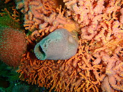 A small vase sponge
 sponges, bushy hydroids and sea fans under an overhang


Features
editThere are several swim-throughs, overhangs and deep gullies, some are described in the Topography section.
 Looking out from under the bus shelter overhang
 Inside of the long swim-through at the west end, looking towards the east entry


Photography
editIf the visibility is good, wide angle lenses with ambient lighting will provide some spectacular views, otherwise macro equipment with flash will almost always produce good results. The use of flash for intermediate distances should be reserved for external strobes to minimize backscatter. Even on a good day there will be some suspended material.
Suggested Routes
editAt this stage only one route is suggested, not because of lack of things to see, but because very few of the features have been mapped.
- Enter at the top of the pinnacle, swim north over the wall and descend to the bottom of the wall. Swim west along or near the base of the wall at a depth of 18 m until you can turn south. Look out for the opening to the big swimthrough at about 18 m - it is not very wide but is quite high - if you turn southwest and find the bus shelter you have gone about 15 m too far. Explore the swimthrough and then continue at between 15 and 18 m with the reef to your left in a roughly southwesterly direction to the "Bus shelter" overhang, Enjoy the view if the visibility allows, and then if you want to look for the smaller swimthrough, continue along the 18 m contour. The smaller swimthrough is in a small indentation in the reef, and the tunnel appears to be several metres long and moderately high, but rather narrow. After this you are on your own. Explore as your time and gas allow, and work your way up the reef to extend dive time. If you find anything interesting, describe it here or on the article's Talk page.
Stay safe
editHazards
editNo known site specific hazards
Skills
editNo special skills required. Certification appropriate to the depth is expected, and the ability to deploy a DSMB is recommended
Equipment
editDry suit recommended, as it will normally be cold if the visibility is good. Nitrox can significantly extend safe dive times. A DSMB and Reel are recommended to indicate your position to the boat while surfacing.
Nearby
edit
- 1 Dreadlocks Reef
- 2 Geldkis Blinder
- 3 Strawberry Rocks
- 4 Geldkis
- 5 Het Huis te Kraaiestein
- 6 Mushroom Pinnacle
- 7 Sandy Cove
- 8 Boardroom pinnacle
- 9 Justin’s Caves
- 10 MV Antipolis
- 11 Klein Pannekoek
- 12 Groot Pannekoek
- 13 Coral Gardens
- 14 Coral Gardens Offshore Pinnacle
- 15 Logies Bay
- 16 MV Romelia
- 17 Steps
Back to the Alphabetical list of sites, or list of dive sites in the Llandudno area
Other regional dive sites:
- Dive sites of Table Bay and approaches
- Dive sites of the Cape Peninsula east coast
- Dive sites of False Bay offshore and approaches
- Dive sites of False Bay east coast
- Fresh water dive sites of the Cape Town Metropolitan Area