Diving at Steps

The dive site Steps is an offshore rocky reef in the Karbonkelberg headland area slightly north of the Oude Schip point on the Atlantic seaboard of the Cape Peninsula, near Cape Town in the Western Cape province of South Africa.
Understand
editPosition
editName
editDerivation of the name "Steps" is not known, but may refer to some topographical feature of the site.
Depth
editMaximum is about 20 m, average depth on a dive is likely to be about 15 m
Visibility
editVisibility will be similar to other reefs in this area. It will usually be best in summer after a few days of south easterly winds cause an upwelling of clear water from the depths. On a good day visibility may exceed 10 m, with 20 m an infrequent possibility.
Topography
editThe reef is separated from the Oude Schip headland by a relatively deep area. The site is a large reef of granite corestones comprising high ridges and deep gullies, some quite narrow. The major jointing is at roughly 200° magnetic, and most of the ridges and gullies are in this direction.
Geology: Late Pre-Cambrian granite of the Peninsula pluton.
Conditions
editOften at its best after a south easterly wind. The site is exposed to the south west swell which will produce a strong surge along the gullies and over the top of the ridges. A south easterly wind will tend to reduce the swell and cause upwelling of clear water from the depths. This water is cold, so good visibility will usually be associated with cold water. Temperatures from 8°C to 14°C are possible, averaging around 11°C in summer. The site is fairly well sheltered from the direct force of the south Easter, and can be dived even in a brisk blow, but the boat ride back to Hout Bay will be into the teeth of the wind.
The site is usually at its best in summer but there may also be occasional opportunities in autumn and early winter.
This is an area which sometimes has upwellings, caused by the south easterly winds, resulting in cold clear water, sometimes followed by a plankton bloom which will then reduce the visibility.
Some of the ridges and gullies are aligned more or less with the direction of the south westerly swell, so the surge can be quite strong both on top of the ridges, and in the gullies, as they provide little protection.
Get in
editThis site is only accessible by boat. It is about 9 km from the Hout Bay harbour.
See
editMarine life
editNot a site where you would expect to see a great number of fish, but quite colorful gully walls with ridge tops either covered in red-bait if fairly shallow, or urchins, if deeper. There are red seaweeds and corallines.
A variety of encrusting, tubular, ball, fan, and wall sponges, anemones and soft corals, sea fans and noble corals, hydroids, colonial ascidians, starfish, sea cucumbers, mussels, whelks and nudibranchs, false corals, fanworms, crabs, rock lobster, amphipods, barnacles and swimming shrimps can be seen
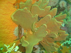 Fan sponge
 Green Moon sponge
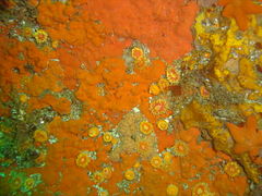 Orange cup corals
 Soft corals
 Sponge and urchins


Photography
editMacro photography will usually produce good results, and if the visibility is good, a wide angle lens may provide some interesting shots. Macro will require flash, but wide angle may be OK with natural light, or external flash to reduce backscatter.
Routes
editNo specific routes recommended.
Stay safe
editNearby
edit
- 1 Logies Bay
- 2 MV Romelia
- 3 MV Harvest Capella
- 4 Rachel's Reef
- 5 Humpback Ridge
- 6 Wilhelm's Wall
- 7 Die Middelmas
- 8 Twin Towers
- 9 MV Keryavor and the Jo May
- 10 SS Maori
- 11 SAS Gelderland
- 12 SS Oakburn / MV Bos 400
- 13 Die Perd
- 14 Kanobi’s Wall
- 15 SURG Pinnacles
- 16 Star Wall
- 17 Sunfish Pinnacle
Back to the Alphabetical list of sites, or list of dive sites in the Oude Schip and Leeugat area
Other regional dive sites:
- Dive sites of Table Bay and approaches
- Dive sites of the Cape Peninsula east coast
- Dive sites of False Bay offshore and approaches
- Dive sites of False Bay east coast
- Fresh water dive sites of the Cape Town Metropolitan Area